
Geelong is a port city in Victoria, Australia, located at the eastern end of Corio Bay and the left bank of Barwon River, about 75 km (47 mi) southwest of Melbourne. With an estimated population of 282,809 in 2023, Geelong is the second largest city in the state of Victoria. It is the administrative centre for the City of Greater Geelong municipality, which is Port Phillip's only regional metropolitan area, and covers all the urban, rural and coastal reserves around the city including the entire Bellarine Peninsula and running from the plains of Lara in the north to the rolling hills of Waurn Ponds to the south, with Corio Bay to the east and the Barrabool Hills to the west.

Sunshine is a suburb in Melbourne, Victoria, Australia, 12 km (7.5 mi) west of Melbourne's Central Business District, located within the City of Brimbank local government area. Sunshine recorded a population of 9,445 at the 2021 census.
Corio is a residential and industrial area, which forms one of the largest suburbs of Geelong, Victoria in Australia. It is located approximately 9 km north of the Geelong central business district. The area was formerly known as Cowie's Creek after James Cowie, an early land owner who was active in the local and state government.
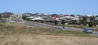
Lovely Banks is a northern suburb of Geelong, Victoria, Australia. Once an agricultural and rural area, the suburb is quickly developing into a residential area adjoining the Geelong suburbs of Bell Park, Corio and Norlane. At the 2016 census Lovely Banks had a population of 2,301.
Waurn Ponds is a mainly residential southern suburb of Geelong, Victoria, Australia.
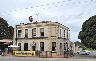
Fyansford is a township on the western edge of Geelong, Victoria, Australia, named after Captain Foster Fyans who came to Geelong as a Police magistrate in October, 1837. It is located at the junction of the Barwon and Moorabool rivers. At the 2016 census, Fyansford had a population of 196.

Norlane is a northern suburb of Geelong, in Victoria, Australia. Norlane is bordered in the south by Cowies Creek, in the north by Cox Road, in the west by Thompson Road and in the east by Station Street. It is about 7 km from the Geelong central business district and approximately 70 km from the state capital, Melbourne. It is about one kilometre from the shore of Corio Bay. At the 2016 census, Norlane had a population of 8,306.
Bell Park is a residential suburb of Geelong, Victoria, Australia. It is located 6 km north-west of the Geelong city centre and is bordered to the north by Cowies Creek, to the east by Thompson Road, to the south by the Midland Highway and to the west by Anakie Road.

North Geelong is a suburb of Geelong in the Australian state of Victoria. The suburb was bypassed by traffic from Melbourne coming from the Princes Freeway by the creation of the Geelong Ring Road, which was complete in 2009. At the 2016 census, North Geelong had a population of 2,966.
Highton is a residential suburb of Geelong, Victoria, Australia. With views across Geelong, Corio Bay and the surrounding region, Highton is located along the banks of the Barwon River and across the rolling Barrabool Hills. The Barwon River straddles Highton to the north and east, while it is bordered by the hilly Ceres and Wandana Heights to the west, the former Kardinia Creek separates the suburb from Belmont to the south-east, and the Princes Highway and Pigdons Road to the south separate the suburb from Waurn Ponds.

Bell Post Hill is a residential suburb of Geelong, Victoria, Australia. At the 2016 census, Bell Post had a population of 4,919.

Rippleside is a suburb of Geelong, Victoria, Australia. The suburb overlooks Corio Bay. At the 2016 census, Rippleside had a population of 875.

The Geelong V/Line rail service is a regional passenger rail service operated by V/Line in Victoria, Australia. It serves 15 stations towards its terminus in Waurn Ponds, a southern suburb of Geelong, via the Regional Rail Link. It is the most used regional rail service in Victoria, carrying 8.15 million people in the 2022-23 financial year.

Geelong railway station is a regional railway station on the Warrnambool line, which is part of the Regional railway network. It serves the city Geelong, in Victoria, Australia. Geelong station is a ground-level unstaffed station, featuring three platforms, an island platform with two faces and one side platform. It opened on 1 November 1856.

North Geelong railway station is a regional railway station on the Warrnambool line, which is part of the Regional railway network. It serves the northern Geelong suburb of North Geelong, in Victoria, Australia. North Geelong station is a ground-level unstaffed station, featuring two side platforms. It opened on 1 August 1883, with the current station provided in 1990.

North Shore railway station is a regional railway station on the Warrnambool line, which is part of the Regional railway network. It serves the northern Geelong suburbs of North Shore and Norlane, in Victoria, Australia. North Shore station is a ground-level unstaffed station, featuring two side platforms. It opened on 15 April 1895, with the current station provided in 1991.

Corio railway station is located on the Warrnambool line in Victoria, Australia. It serves the northern Geelong suburb of Corio, and it opened on 15 September 1890 as Cowie's Creek. It was renamed Cowie on 9 May 1904, and renamed Corio on 1 December 1913.

The Geelong and Melbourne Railway Company was a railway company in Victoria, Australia. Alexander Thomson, a member of the Victorian Legislative Council, introduced and mentored a bill to incorporate the Geelong and Melbourne Railway Company. On 8 February 1853, the operation of Melbourne and Geelong Railway Company and Mount Alexander and Murray River Railway Company was approved by the Victoria Government. Thomson was one of the directors and presided at the first shareholder meeting. Work began at the Geelong end in 1854 but progress was slow due to a labour shortage caused by the Victorian gold rush, so the Victorian government hired out 100 prisoners to the company at a daily rate of five shillings each. They were housed in prison hulks moored in Corio Bay. English engineer and surveyor, Edward Snell, undertook the survey and design of the line, including a station and extensive workshops at Geelong, and a number of bluestone and timber bridges.

The Port of Geelong is located on the shores of Corio Bay at Geelong, Victoria, Australia. The port is the sixth-largest in Australia by tonnage.
Cowies Creek Rail Bridge No. 1 is a bridge in Victoria, Australia, on the Geelong-Ballarat rail line in the outer Geelong suburb of Bell Post Hill. Constructed of bluestone in 1860 to cross both Cowies Creek and a roadway, the structure is listed in the Victorian Heritage Register.


