
Eltham is a suburb of Melbourne, Victoria, Australia, 20 km north-east of the Central Business District, located within the Shire of Nillumbik local government area. Eltham recorded a population of 18,847 at the 2021 census.

Campbellfield is a suburb of Melbourne, Victoria, Australia, 13km north of Melbourne's central business district, located within the City of Hume local government area. Campbellfield recorded a population of 4,977 at the 2021 census.

Sunshine is a suburb of Melbourne, Australia, 12 km west of the CBD, located within the City of Brimbank local government area. Sunshine recorded a population of 9,768 at the 2016 census.
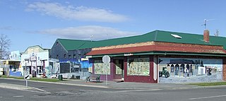
Nar Nar Goon is a town in Gippsland, Victoria, Australia, 61 km south-east of Melbourne's Central Business District, located within the Shire of Cardinia local government area. Nar Nar Goon recorded a population of 1,012 at the 2016 census.

Grovedale is a southern suburb of Geelong, Victoria, Australia. At the 2021 census, Grovedale had a population of 14,869.
Little River is a town in Victoria, Australia, that is located about 49 kilometres (30 mi) south-west of the Melbourne central business district, located within the Cities of Greater Geelong and Wyndham local government areas. Little River recorded a population of 1,322 at the 2016 census.
Waurn Ponds is a mainly residential southern suburb of Geelong, Victoria, Australia.

Norlane is a northern suburb of Geelong, in Victoria, Australia. Norlane is bordered in the south by Cowies Creek, in the north by Cox Road, in the west by Thompson Road and in the east by Station Street. It is about 7 km from the Geelong central business district and approximately 70 km from the state capital, Melbourne. It is about one kilometre from the shore of Corio Bay. At the 2016 census, Norlane had a population of 8,306.
Moolap is a residential and industrial suburb of Geelong, Victoria, Australia. The name Moolap is derived from an Aboriginal word for nearby Point Henry, moo-laa, thought to mean 'men gathering to go fishing'.

North Geelong is a suburb of Geelong in the Australian state of Victoria. The suburb was bypassed by traffic from Melbourne coming from the Princes Freeway by the creation of the Geelong Ring Road, which was complete in 2009. At the 2016 census, North Geelong had a population of 2,966.
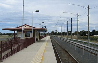
Marshall railway station is located on the Warrnambool line in Victoria, Australia. It serves the southern Geelong suburb of Marshall, and opened on 26 April 2005.
Mount Duneed is a suburb of Geelong, Victoria, Australia. It is divided between the City of Greater Geelong and Surf Coast Shire local government areas. Mount Duneed itself is an extinct volcano and the remains of the crater can be seen in the Mount Duneed Recreation Reserve.

Lang Lang is a town in Victoria, Australia, 73 km south-east of Melbourne's Central Business District, located within the Shires of Bass Coast, Cardinia and South Gippsland local government areas. Lang Lang recorded a population of 1,585 at the 2016 census.

Woodridge is a town and suburb in the City of Logan, Queensland, Australia. In the 2016 census, the suburb of Woodridge had a population of 12,579 people. Woodridge was home to a major timber reserve.

Ilfracombe is a rural town and locality in the Longreach Region, Queensland, Australia. In the 2016 census, the locality of Ilfracombe had a population of 259 people.
Connewarre, is a locality in Victoria, Australia, is located in the City of Greater Geelong and Surf Coast Shire, and is named after Lake Connewarre which is situated immediately to its north-east. Connewarre is a version of "kunuwarra", the name of the black swan in the Wathawurrung language. At the 2016 census, Connewarre and the surrounding area had a population of 788.
The Armstrong Creek Growth Area is a southern extension to the urban growth boundary of the metropolitan area of Geelong, Victoria, Australia. It comprises parts of the localities of Grovedale and Marshall south of the Warrnambool railway line, and parts of the localities of Mount Duneed and Connewarre from some distance to the north of Lower Duneed Road and generally to the west of Barwon Heads Road.
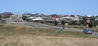
Armstrong Creek is a suburb of Geelong, Victoria, Australia. It was gazetted in February 2012 as part of the Armstrong Creek Growth Area, and was mostly farm land which had been part of Connewarre and Mount Duneed. At the 2021 census, Armstrong Creek had a population of 11,247.
Charlemont is a suburb of Geelong, Victoria, Australia. At the 2021 census, Charlemont had a population of 2,612, growing from 364 taken at the 2016 census. It was gazetted in February 2012 as part of the Armstrong Creek Growth Area, from largely undeveloped land which had formerly been part of Grovedale and Marshall.
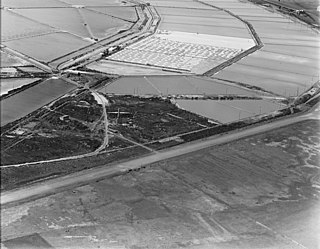
Grovedale was a railway station on the outskirts of Geelong, located on the Warrnambool railway line in Victoria, Australia. Located near the current Torquay Road level crossing, the station opened in 1876 as Germantown and was renamed Grovedale in February 1916.
