South Geelong, Victoria

Last updated

South Geelong
Geelong,  Victoria
Skilled-stadium-geelong.jpg
Population993 (2016 census) [1]
Postcode(s) 3220
Location2 km (1 mi) from Geelong
LGA(s) City of Greater Geelong
State electorate(s) Geelong
Federal division(s) Corio
Suburbs around South Geelong:
Newtown Geelong CBD East Geelong
Newtown South Geelong Thomson
Belmont Belmont Breakwater

South Geelong, also referred to as Geelong South, is a southern suburb of Geelong, Victoria, Australia. Its local government area is the City of Greater Geelong. At the 2016 census, South Geelong had a population of 993. [1]

Contents

The suburb is adjacent to the Geelong central business district, with the Barwon River forming the suburb's southern border. South Geelong is also the western start point for the Bellarine Rail Trail, a 32 km walking and cycling track to Queenscliff.

Major industry in South Geelong includes the Godfrey Hirst Pty Ltd carpet manufacturers on Barwon Terrace currently (2009) owned by the McKendrick family.

The Post Office opened on 1 June 1921 as South Geelong and was renamed Geelong South in 1941. [2]

Demographics

As of the 2011 census, 907 people resided in 459 private dwellings. About 79.8% of people from South Geelong are Australian born, with the most common overseas birthplaces being: England (3.1%), India (1.5%) China (1.2%) Italy (1%), Scotland (.9%).

50.3% of people from South Geelong are Christian, 30% stated No Religion. [3]

History

Aerial perspective of Kardinia Park Stadium with South Geelong station Aerial perspective of Kardinia Park Stadium with South Geelong station.jpg
Aerial perspective of Kardinia Park Stadium with South Geelong station

South Geelong is one of the oldest suburbs in Geelong and it was the location of the first house ever built in Geelong.

In a letter to His Excellency Charles Joseph Latrobe, Esq., Lieutenant-Governor of the Colony of Victoria, dated September 21, 1853, Mr. David Fisher writes: "In the latter end of the year 1836 I returned to Port Phillip for the purpose of forming the different stations afterwards occupied by the Derwent Co., and pitched my tent on the south side of Geelong, on the north bank of the Barwon River, near where a bridge was afterwards built communicating with the Western District. Here I built the first home in Geelong worthy of the name; it is built of weatherboards of Van Diemen 1s Land timber, which house yet stands and is still an ornament to what is now called Barwon Terrace. In this house I had the honor of receiving His Excellency Sir Richard Bourke, who had come hither to spy out the nakedness of the land, and with his suite encamped on the banks of the Barwon next to my house. It is worthy of remark that on the night of Sir Richard Bourke's arrival the district was visited by an earthquake, the shock of which was felt all over the district. Such a phenomenon has never occurred since that time, but I was informed by a very old native, King Murradock, that such had been felt before, but it was 'long, long ago.' In the month of September (1837), having finished my home and got all things comfortable for the occupation of my family, I proceeded to Van Diemen's Land to bring them over, taking my passage by the James Watt, the first steam vessel that visited these shores. In the month of March following (1838) I returned with my family." [4]

Heritage Listed Sites

South Geelong has a number of heritage listed sites, including:

Entertainment

South Geelong has a number of historic and new pubs, restaurants, and the only independent movie theater in Geelong.

The Barwon Club Hotel on Moorabool street has been in operation as hotel under various names since 1856. [17]

The Pivitonian Cinema opened in 2016. [18]

The official Escape Room Geelong opened in South Geelong in late 2015.

Sporting facilities

Geelong: aerial perspective of Richmond Crescent Geelong aerial perspective of Richmond Crescent.jpg
Geelong: aerial perspective of Richmond Crescent

John Landy Athletic Field is located on the corner of Barwon Terrace and Swanston Street. Developed in the early 1960s and opened for competition in late 1961, Landy Field is home to the Little Athletics movement developed by Geelong resident Trevor Billingham B.E.M.

Landy Field is home to Geelong Athletics, the Geelong Little Athletics Centre and the Geelong Masters group. The venue is managed by the John Landy Field Management Committee under a licence agreement with the Geelong Council.

South Geelong is also home to two of the oldest rowing clubs in Australia: the Barwon Rowing Club (founded in 1870), [19] and the Corio Bay Rowing Club (founded in 1873). [20]

South Geelong is the start of the Bellarine Rail Trail, a 32 km walking and cycling track on the Bellarine Peninsula, in Victoria, Australia, that follows the route of the former South Geelong to Queenscliff branch line

See also

Related Research Articles

Geelong is a port city in the southeastern Australian state of Victoria, located at the eastern end of Corio Bay and the left bank of Barwon River, about 65 km (40 mi) southwest of Melbourne, the state capital of Victoria.

City of Greater Geelong Local government area in Victoria, Australia

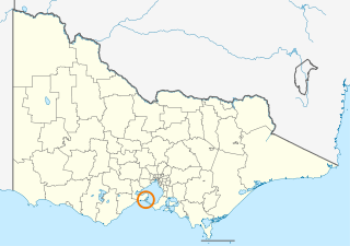
The City of Greater Geelong is a local government area in the Barwon South West region of Victoria, Australia, located in the western part of the state. It covers an area of 1,248 square kilometres (482 sq mi) and, in June 2018, had a population of 252,217. It is primarily urban with the vast majority of its population living in the Greater Geelong urban area, while other significant settlements within the LGA include Anakie, Balliang, Barwon Heads, Batesford, Ceres, Clifton Springs, Drysdale, Lara, Ocean Grove, Portarlington and St Leonards. It was formed in 1993 from the amalgamation of the Rural City of Bellarine, Shire of Corio, City of Geelong, City of Geelong West, City of Newtown, City of South Barwon, and parts of Shire of Barrabool and Shire of Bannockburn.

Borough of Queenscliffe Local government area in Victoria, Australia

The Borough of Queenscliffe is a local government area in the Barwon South West region of Victoria, Australia, located in the southern part of the state. It is the smallest local government area in Victoria, covering an area of 10.83 square kilometres (4.18 sq mi) and, in June 2018, had a population of 2,982. It includes only two settlements, which are Queenscliff and Point Lonsdale. It is situated on the south coast, south-east of Geelong on the Bellarine Peninsula south of Swan Bay and next to the Port Phillip Heads, the entrance to Port Phillip Bay from Bass Strait.

Heidelberg, Victoria Suburb of Melbourne, Victoria, Australia

Heidelberg is a suburb of Melbourne, Victoria, Australia, 11 kilometres (7 mi) northeast of Melbourne's central business district. Its local government area is the City of Banyule. In 2016, Heidelberg had a population of 6,225.

Ivanhoe East, Victoria Suburb of Melbourne, Victoria, Australia

Ivanhoe East is a suburb of Melbourne, Victoria, Australia, 10 km north-east from Melbourne's Central Business District. Its local government area is the City of Banyule. At the 2016 census, Ivanhoe East had a population of 3,815.

Murrumbeena, Victoria Suburb of Melbourne, Victoria, Australia

Murrumbeena is a suburb in Melbourne, Victoria, Australia, 13 km south-east of Melbourne's central business district. Its local government area is the City of Glen Eira. At the 2016 census, Murrumbeena had a population of 9,926.

Barwon River (Victoria) Perennial river in Victoria, Australia

The Barwon River is a perennial river of the Corangamite catchment, located in The Otways and the Bellarine Peninsula regions of the Australian state of Victoria.

Belmont, Victoria Suburb of Geelong, Victoria, Australia

Belmont is a southern suburb of Geelong, Victoria, Australia. The name means "beautiful hill". Belmont is geographically separated from the Geelong central business district by the Barwon River. The suburb is primarily residential, with some light industry along Barwon Heads Road. The suburb is part of the City of Greater Geelong local government area. At the 2011 census, Belmont had a population of 13,616.

Herne Hill, Victoria Suburb of Geelong, Victoria, Australia

Herne Hill is a residential suburb of Geelong, Victoria, Australia. At the 2016 census, Herne Hill had a population of 3,413. It is in the federal Division of Corio, and its postcode is 3218.

Hamlyn Heights, Victoria Suburb of Geelong, Victoria, Australia

Hamlyn Heights is a residential suburb of Geelong. It located to the west of the city on hills that overlook Corio Bay.

Point Lonsdale Town in Victoria, Australia

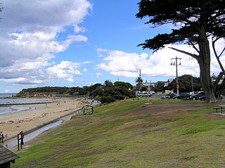
Point Lonsdale is a coastal township on the Bellarine Peninsula, near Queenscliff, Victoria, Australia. The town is divided between the Borough of Queenscliffe and the City of Greater Geelong. Point Lonsdale is also one of the headlands which, with Point Nepean, frame The Rip, the entrance to Port Phillip. The headland is dominated by the Point Lonsdale Lighthouse. At the 2016 census, Point Lonsdale had a population of 2,684. The population grows rapidly over the summer months through to the Easter period due to its popularity as a holiday destination.

Geelong Ring Road Freeway in Victoria, Australia

The Geelong Ring Road is a freeway ring road in Australia beside Geelong's western suburbs from the Princes Freeway at Corio to the Princes Highway at Waurn Ponds. It also connects to the Midland Highway towards Ballarat, and the Hamilton Highway.

Bellarine Highway

Bellarine Highway is a main arterial highway that runs east from Geelong in Victoria along the Bellarine Peninsula to Queenscliff. The highway also provides the main route to Barwon Heads and Ocean Grove, localities along the southern coast of the peninsula.

City of Geelong Local government area in Victoria, Australia

The City of Geelong was a local government area about 75 kilometres (47 mi) southwest of Melbourne, the state capital of Victoria, Australia. The city covered an area of 13.4 square kilometres (5.2 sq mi), and existed from 1849 until 1993.

Queenscliff railway station

Queenscliff is the terminal railway station of the Queenscliff branch line that originally branched off the main Warrnambool line near South Geelong in Victoria, Australia. The station was originally opened on 21 May 1879, the current station building constructed in 1881 and is listed on the Victorian Heritage Register.

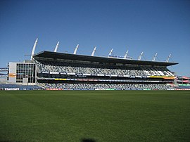
Kardinia Park is a major public park located in South Geelong, Victoria. A number of public and sporting facilities are located in the park: a major AFL stadium, a secondary football oval, a cricket field, an open air swimming pool, a number of netball courts, various sporting clubrooms, and a senior citizens centre. The park is bounded by Moorabool Street, the Geelong railway line, Kilgour Street, Latrobe Terrace, and Park Crescent.

Bellarine Football League

The Bellarine Football Netball League is an Australian rules football and netball competition based in the Bellarine Peninsula region of Victoria, Australia, formed in 1971.

Landy Field

John Landy Athletics Field is situated at the corner of Swanston Street and Barwon Terrace, South Geelong, and was formerly known as Riverside Reserve. It sits adjacent to the Barwon River to the south and the Godfrey Hirst Pty Ltd carpet factory to the east. it is considered the premier athletics venue in the Geelong region, and its track is of national standard. Landy Field is located close to Kardinia Park. Landy Field was the venue for the 2016 Victoria Country Athletics Championships. The venue itself is open 24 hours. Landy Field is an associated venue of the Geelong Cross Country Club.

Edward Prowse was an architect working in the Geelong region of Victoria, Australia in the late nineteenth century. He was responsible for many early Geelong buildings, including hotels, mansions and churches.

Oakden, Addison and Kemp was an Australian architectural firm in Melbourne, Victoria. While it was short lived, existing from only 1887 to 1892, they designed a number of outstanding projects, and all three members designed many more notable projects in earlier and later partnerships.

References

  1. 1 2 Australian Bureau of Statistics (27 June 2017). "South Geelong (State Suburb)". 2016 Census QuickStats. Retrieved 16 November 2017. OOjs UI icon edit-ltr-progressive.svg
  2. Phoenix Auctions History, Post Office List , retrieved 10 March 2021
  3. Australian Bureau of Statistics (31 October 2012). "South Geelong (State Suburb)". 2011 Census QuickStats. Retrieved 3 August 2017. OOjs UI icon edit-ltr-progressive.svg
  4. Compiled by J.H. Bottrell (1933). Early History of South Geelong. Australia: Geelong Advertiser. p. 1.
  5. "VHD". vhd.heritagecouncil.vic.gov.au. Retrieved 1 November 2016.
  6. 1 2 "VHD". vhd.heritagecouncil.vic.gov.au. Retrieved 1 November 2016.
  7. "VHD". vhd.heritagecouncil.vic.gov.au. Retrieved 1 November 2016.
  8. 1 2 3 "VHD". vhd.heritagecouncil.vic.gov.au. Retrieved 1 November 2016.
  9. "VHD". vhd.heritagecouncil.vic.gov.au. Retrieved 1 November 2016.
  10. "VHD". vhd.heritagecouncil.vic.gov.au. Retrieved 1 November 2016.
  11. "VHD". vhd.heritagecouncil.vic.gov.au. Retrieved 1 November 2016.
  12. "VHD". vhd.heritagecouncil.vic.gov.au. Retrieved 1 November 2016.
  13. "VHD". vhd.heritagecouncil.vic.gov.au. Retrieved 1 November 2016.
  14. "VHD". vhd.heritagecouncil.vic.gov.au. Retrieved 1 November 2016.
  15. "VHD". vhd.heritagecouncil.vic.gov.au. Retrieved 1 November 2016.
  16. "VHD". vhd.heritagecouncil.vic.gov.au. Retrieved 1 November 2016.
  17. "Hotels". zades.com.au. Retrieved 1 November 2016.
  18. "Art house cinema back in business" . Retrieved 1 November 2016.
  19. "Barwon Rowing Club - Australian Rowing History". www.rowinghistory-aus.info. Retrieved 1 November 2016.
  20. "A Brief History of Corio Bay Rowing Club – Established 1873".