
Port Phillip , is a horsehead-shaped bay on the central coastline of southern Victoria, Australia, and opens into the Bass Strait through a narrow channel known as The Rip. The bay is surrounded mostly by metropolitan Greater Melbourne in its main eastern portion north of the Mornington Peninsula, and the city of Greater Geelong in the much smaller western portion north of the Bellarine Peninsula. Geographically, the bay covers 1,930 square kilometres and the shore stretches roughly 264 km (164 mi), with the volume of water around 25 cubic kilometres (6.0 cu mi). Most of the bay is navigable, although it is extremely shallow for its size—the deepest portion is only 24 metres (79 ft), and half the bay is shallower than 8 m (26 ft).
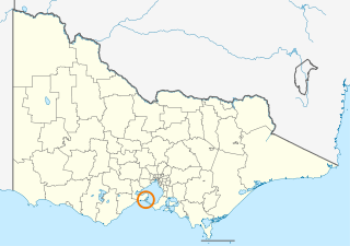
The Borough of Queenscliffe is a local government area in the Barwon South West region of Victoria, Australia, located in the southern part of the state. It is the smallest local government area in Victoria, covering an area of 10.83 square kilometres (4.18 sq mi) and, in June 2018, had a population of 2,982. It includes only two settlements, which are Queenscliff and Point Lonsdale. It is situated on the south coast, south-east of Geelong on the Bellarine Peninsula south of Swan Bay and next to the Port Phillip Heads, the entrance to Port Phillip Bay from Bass Strait.

Searoad Ferries is an Australian company that operates a roll-on/roll-off vehicle and passenger ferry service between the heads of Port Phillip, near Melbourne, Victoria, Australia.

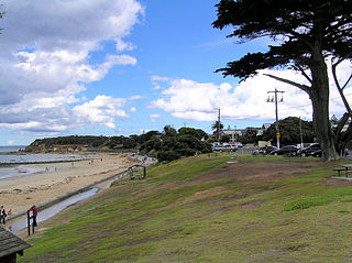
Queenscliff is a small town on the Bellarine Peninsula in southern Victoria, Australia, south of Swan Bay at the entrance to Port Phillip. It is the administrative centre for the Borough of Queenscliffe. At the 2016 census, Queenscliff had a population of 1,315.

The Mud Islands reserve is located within Port Phillip, about 90 km (56 mi) south-west of Melbourne, Australia, lying 10 km (6.2 mi) inside Port Phillip Heads, 7 km (4.3 mi) north of Portsea and 9 km (5.6 mi) east of Queenscliff. The land area of about 50 hectares is made up of three low-lying islands surrounding a shallow tidal 35-hectare (86-acre) lagoon connected to the sea by three narrow channels. The shapes and configuration of the islands change over the years due to movement of sand by tidal currents.
Point Lonsdale is a coastal township on the Bellarine Peninsula, near Queenscliff, Victoria, Australia. The town is divided between the Borough of Queenscliffe and the City of Greater Geelong. Point Lonsdale is also one of the headlands which, with Point Nepean, frame The Rip, the entrance to Port Phillip. The headland is dominated by the Point Lonsdale Lighthouse. At the 2016 census, Point Lonsdale had a population of 2,684. The population grows rapidly over the Summer months through to the Easter period as it is a hot holiday destination.

The Bellarine Peninsula is a peninsula located south-west of Melbourne in Victoria, Australia, surrounded by Port Phillip, Corio Bay and Bass Strait. The peninsula, together with the Mornington Peninsula separates Port Phillip from Bass Strait. The peninsula itself was originally occupied by Indigenous Australian clans of the Wathaurong nation, prior to European settlement in the early 19th century. Early European settlements were initially centred on wheat and grain agriculture, before the area became a popular tourist destination with most visitors arriving by paddle steamer on Port Phillip in the late 19th century.
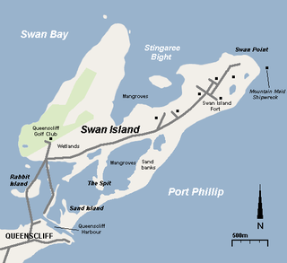
Swan Island is a 1.4 km2 sand barrier island which, with Duck Island and the Edwards Point spit, separate Swan Bay from Port Phillip in Victoria, Australia. It lies close to and north of the town of Queenscliff at the eastern end of the Bellarine Peninsula, and is an official bounded locality of the Borough of Queenscliffe.

Duck Island, a small barrier island, lies 1.5 km north of Swan Island and south of Edwards Point in the main entrance to Swan Bay from Port Phillip in southern Victoria, Australia. It is part of the Port Phillip Heads Marine National Park and the plants and animals on and around the island are protected, including the critically endangered orange-bellied parrot. The island is part of the Swan Bay and Port Phillip Bay Islands Important Bird Area, identified as such by BirdLife International.

The Swan Bay is a shallow, 30-square-kilometre (12 sq mi) marine embayment at the eastern end of the Bellarine Peninsula in Port Phillip, Victoria, Australia. The township of Queenscliff lies at its southern end, and St Leonards at its northern. It is partly separated from Port Phillip by Swan Island, Duck Island and Edwards Point. Most of the area is included in the Port Phillip Heads Marine National Park as well as being listed as a wetland of international importance under the Ramsar Convention as part of the Port Phillip Bay and Bellarine Peninsula Ramsar Site. The bay is part of the Swan Bay and Port Phillip Bay Islands Important Bird Area, identified as such by BirdLife International because of its importance for orange-bellied parrots, waders and seabirds.
Edwards Point is a 4 km long sand spit extending southwards between Swan Bay and Port Phillip Bay, at the eastern end of the Bellarine Peninsula, Victoria, Australia. It is about 115 km by road south-west of Melbourne and 40 km east of Geelong.

Fort Queenscliff, in Victoria, Australia, dates from 1860 when an open battery was constructed on Shortland's Bluff to defend the entrance to Port Phillip. The Fort, which underwent major redevelopment in the late 1870s and 1880s, became the headquarters for an extensive chain of forts around Port Phillip Heads. Its garrison included volunteer artillery, engineers, infantry and naval militia, and it was manned as a coastal defence installation continuously from 1883 to 1946. The other fortifications and armaments around the Heads were completed by 1891, and together made Port Phillip one of the most heavily defended harbours in the British Empire.

Pope's Eye is the uncompleted foundation for an island fort intended to defend the entrance to Port Phillip in the state of Victoria, Australia. The undefined area of the fort, generally assessed at 4 hectares, is one of six separate areas that comprise the Port Phillip Heads Marine National Park and is a popular site for divers.
The Port Phillip Heads Marine National Park is a marine protected area located in the vicinity of the bay of Port Phillip, between the Bellarine and Mornington Peninsulas, in Victoria, Australia. The 3,580-hectare (8,800-acre) marine national park comprises six separate sites located approximately 60 kilometres (37 mi) south-west of Melbourne and stretches along 40 kilometres (25 mi) of coastline of Victoria.

South Channel Fort, also known as South Channel Island, is a 0.7 ha artificial island in southern Port Phillip, Victoria, Australia, 6 km north-east of the town of Sorrento. It was part of a network of fortifications protecting the narrow entrance to Port Phillip.

Port Phillip, sometimes referred to as Port Phillip Bay, is a large bay in southern Victoria, Australia, 1,930 km² in area, with a coastline length of 264 km (164 mi). The bay is extremely shallow for its size, but mostly navigable. The deepest portion is only 24 m, and half the region is shallower than 8 m. Its volume is around 25 km³. The city of Melbourne is located at its northern end, near the mouth of the Yarra River.
Jack Kenneth Loney was an amateur Australian marine historian who published over one hundred books and numerous newspaper and magazine articles. He was a schoolteacher and principal until his retirement. He became interested in maritime history after preparing several general history booklets covering the Otway region of western Victoria, Australia.
HMVS Lonsdale was a second-class torpedo boat constructed for the Victorian Naval Forces and later operated by the Commonwealth Naval Forces and the Royal Australian Navy. She was sunk on mud flats on Swan Island in Port Phillip Bay in 1912 after being stripped of equipment and machinery. Having been commissioned in 1884, and then officially joining the Commonwealth Naval forces in 1901, the boat was the oldest ship in the Royal Navy, and is the oldest Royal Australian Navy ship still in existence.
HMVS Nepean was a second-class torpedo boat constructed for the Victorian Naval Forces and later operated by the Commonwealth Naval Forces and the Royal Australian Navy. She was sunk on mud flats on Swan Island in Port Phillip Bay in 1912 after being stripped of equipment and machinery.
The Swan Bay and Port Phillip Bay Islands Important Bird Area comprises a cluster of disparate sites centred at the eastern end of the Bellarine Peninsula, and the southern end of Port Phillip, in Victoria, south-eastern Australia. As well as providing core wintering habitat for orange-bellied parrots, it is important for waders, or shorebirds, and seabirds.
