
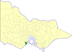
The Surf Coast Shire is a local government area in the Barwon South West region of Victoria, Australia, located in the south-western part of the state. It covers an area of 1,553 square kilometres (600 sq mi) and in June 2018 had a population of 32,251. It includes the towns of Aireys Inlet, Anglesea, Lorne, Moriac, Torquay and Winchelsea. It was formed in 1994 from the amalgamation of the Shire of Winchelsea, Shire of Barrabool and part of the former City of South Barwon, which was, at that point, part of the City of Greater Geelong.

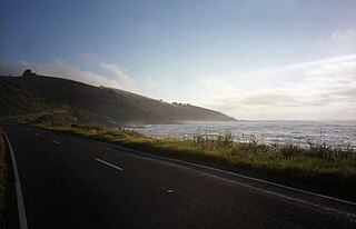
Aireys Inlet is a small coastal inlet and town located on the Great Ocean Road, southwest of Melbourne, Victoria, Australia. Aireys Inlet is located between Anglesea and Lorne, and joined with Fairhaven, Moggs Creek, and Eastern View to the west.
Point Leo is a rural surfing locality in the Shire of Mornington Peninsula, Victoria, Australia. Point Leo Foreshore Reserve provides excellent waves for surfing and is one of the closest surf beaches to Melbourne. At the 2016 census, Point Leo had a population of 158.

Inverloch is a seaside town located in Victoria, Australia. It is located 143 kilometres (89 mi) south east of Melbourne via the South Gippsland Highway on the Bass Highway in the Bass Coast Shire of Gippsland, Victoria, Australia. Known originally for the calm waters of Anderson Inlet, it is now also known for the discovery of Australia's first dinosaur bone.

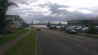
Anglesea is a town in Victoria, Australia. It is located on the Great Ocean Road in the Surf Coast Shire local government area. In the 2016 census, Anglesea had a population of 2,545 people.

Wye River is a small town in Victoria, Australia. It is also the name given to the waterway which flows through the town and into the sea at this point. Situated some 155 km west of Melbourne, on the Otway Coast part of the scenic Great Ocean Road, the Wye River township is a popular tourist destination about 15 km west of the resort town of Lorne, Victoria. It became a popular place for Melburnians to holiday after the Great Ocean Road was officially opened in 1932. The postcode of Wye River is 3234. At the 2016 census, Wye River had a permanent population of 66 although its holiday population is ten times that number.
Mollymook is located on the South Coast of New South Wales, Australia approximately three hours' drive south of Sydney within the City of Shoalhaven local government area. At the 2016 census, Mollymook had a population of 1,083 while the adjacent locality of Mollymook Beach was home to a further 2,447 people. Geographically, Mollymook is considered part of the Milton-Ulladulla district, a coastal corridor of urban development stretching from Burrill Lake, south of Ulladulla to Mollymook's northern neighbour, Narrawallee and the historic town of Milton a few kilometres inland.

Bilinga is a southern coastal suburb in the City of Gold Coast, Queensland, Australia. In the 2016 census, Bilinga had a population of 1,804 people. It is on the border with New South Wales.

Elouera Beach or Elouera is a patrolled beach on Bate Bay, in Cronulla, New South Wales, Australia. The Wall is the local name given to the area between North Cronulla Beach and Elouera.

Cape Paterson is a cape and seaside village located near the town of Wonthaggi, 132 kilometres (82 mi) south-east of Melbourne via the South Gippsland and Bass Highways, in the Bass Coast Shire of Gippsland, Victoria, Australia. Known originally for the discovery of coal by William Hovell in 1826, it is now extremely popular for its beaches and rockpool and at the 2011 census, it had a population of 718.

Surf Life Saving Australia (SLSA) is an Australian not-for-profit community organisation that promotes water safety and provides surf rescue services.

Breamlea, Victoria, Australia, is a secluded seaside hamlet located on the south coast of the Bellarine Peninsula, 18 kilometres south of Geelong and halfway between Barwon Heads and Torquay. It is divided between the City of Greater Geelong and the Surf Coast Shire. In the 2016 census, Breamlea had a permanent population of 162.
The Shire of Barrabool was a local government area about 100 kilometres (62 mi) southwest of Melbourne, the state capital of Victoria, Australia. The shire covered an area of 575.18 square kilometres (222.1 sq mi), and existed from 1853 until 1994.
Woodside Beach is a rural locality with a popular surf beach in Victoria, Australia. It is approximately 10 km from the town of Woodside, and can be reached by the Woodside Beach Road. Areas of interest surrounding Woodside Beach include Balloong Natural Interest Reserve, Jack Smith Lake and McLoughlins Beach.

Narrawallee is a coastal village in the South Coast region of New South Wales, Australia. At the 2016 census, it had a population of 1,241. The village, along with its southern neighbours Mollymook and Mollymook Beach are generally considered part of the Milton-Ulladulla district within the City of Shoalhaven local government area. Narrawallee is predominantly a residential suburb, bordered by a tidal inlet to the north and Matron Porter Drive. The name "Narrawallee" is taken from the creek which flows eastwards from Milton and its estuary on the Tasman Sea and is itself a corruption of the Aboriginal words Nurrawerree or Narra Warra.
Forrest Beach is a small coastal locality in the Shire of Hinchinbrook, Queensland, Australia. In the 2016 census, Forrest Beach had a population of 1,254 people.
Modewarre is a locality in the Surf Coast Shire, Victoria, Australia. The town adjoins Lake Modewarre. In the 2016 census, Modewarre had a population of 276 people.
Big Hill is a coastal locality in the Surf Coast Shire, Victoria, Australia.
Eastern View is a locality in the Surf Coast Shire, Victoria, Australia.

Main Beach Pavilion and Southport Surf Lifesaving Club are heritage-listed beach buildings off Macarthur Parade, Main Beach, Queensland, Australia. The Main Beach Pavilion was designed by Thomas Ramsay Hall and Lionel Blythewood Phillips of the architectural firm Hall and Phillips and built in 1934 for the Southport Town Council. The Surf Lifesaving Club was also designed by Hall and Phillips and built adjacent in 1936 for the club. They were added to the Queensland Heritage Register on 1 March 1995.

