Aireys Inlet

Last updated

Aireys Inlet
Victoria
Aireys Inlet Lighthouse.jpg
Panorama of Aireys Inlet with Lighthouse in background
Australia Victoria Surf Coast Shire location map.svg
Red pog.svg
Aireys Inlet
Coordinates 38°28′S144°06′E / 38.467°S 144.100°E / -38.467; 144.100 Coordinates: 38°28′S144°06′E / 38.467°S 144.100°E / -38.467; 144.100
Population979 (2021 census) [1]
Postcode(s) 3231
Elevation95 m (312 ft)
Location
LGA(s) Surf Coast Shire
State electorate(s) Polwarth
Federal division(s) Corangamite
Localities around Aireys Inlet:
Wensleydale Anglesea Anglesea
Eastern View Aireys Inlet Bass Strait
Moggs Creek Fairhaven Bass Strait

Aireys Inlet is a small coastal inlet and town located on the Great Ocean Road, southwest of Melbourne, Victoria, Australia. Aireys Inlet is located between Anglesea and Lorne, and joined with Fairhaven, Moggs Creek, and Eastern View to the west.

Contents

Many surfers holiday in Aireys Inlet to take advantage of the popular Fairhaven beach. As the inclination of the beach can change dramatically between years, the surf is regarded as unpredictable. Swimmers should take note there is a strong rip current.

Painkalac Creek, which separates Aireys Inlet from Fairhaven, forms a salt lake or inlet behind the sand dunes before it cuts through to the ocean. Due to low water levels in the inlet it is not often that the inlet breaks through.

Aireys Inlet is also famous for Split Point Lighthouse which was featured in the popular children's TV show Round The Twist.

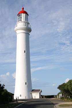
There is also a horseshoe-shaped reef at Step Beach which forms an excellent swimming hole at low tide. The towns main attraction, the Split Point Lighthouse overlooks the inlet. The lighthouse has made Aireys Inlet an icon along the Great Ocean Road.

History

In the early 19th century, before British settlement, the escaped convict William Buckley lived here in a primitive hut eating fish, shellfish, wild raspberries and sugar ants. Aireys Inlet was known to the Aboriginals of the time as Managwhawz. The town takes its current name from John Moore Cole Airey, who settled in the area in 1842. [2]

The Post Office opened on 1 April 1893. [3]

Population

At the 2016 census, Aireys Inlet had a population of 802. 83.4% of people were born in Australia and 88.3% of people only spoke English at home. The most common responses for religion were No Religion 53.9% and Catholic 16.1%. [4]

Geography

Fairhaven, Moggs Creek, and Eastern View are in the same postal area as Aireys Inlet.

School

Aireys Inlet has one school, Aireys Inlet Primary School (P-6), which until the end of 2016 was a campus of the then Lorne-Aireys Inlet P-12 College.

Sport

Literature and media

Great Ocean Road Great ocean road.jpg
Great Ocean Road

During the early 1950s the Australian crime author Arthur Upfield lived at Aireys Inlet. His novel The New Shoe (1951) is based on the township and the lighthouse. Some of the novel's characters drew on local identities.

Many scenes from the children's television series Round the Twist were filmed at or around the area of the Split Point Lighthouse.

In 2005 the Bollywood movie Salaam Namaste was produced in Melbourne with many scenes being shot around Aireys Inlet, Fairhaven and Anglesea.

Beaches and coastline

Split Point Lighthouse SplitPoint 0072.jpg
Split Point Lighthouse

While the coastline at adjacent Fairhaven is a long uninterrupted sand beach, the coast at Aireys Inlet is a series of rock shelves, interrupted by sandy swimming beaches, most of which are relatively secluded. Each beach has its own character, a result of differing lengths, orientation and nearby rock formations. Beaches include Sandy Gully, Steppy Beach and Sunnymeade.

At low tide it is possible to walk (or scramble) around all these rocks and beaches, making it possible to walk along the beach, all the way from Eastern View - the historical start of the Great Ocean Road, all the way to Anglesea.

1983 Ash Wednesday bushfires

Aireys Inlet was devastated by the infamous 1983 Ash Wednesday bushfires in which a large number of houses were burnt down. However, after a brief lull, interest in the area resumed and has been steadily climbing since. Properties, especially those with an ocean view, are becoming increasingly sought after, some going for greater than A$1 million.

Heritage listed sites

Aireys Inlet has a number of heritage listed sites, including:

Notable people

Related Research Articles

<span class="mw-page-title-main">Great Ocean Road</span>

The Great Ocean Road is an Australian National Heritage listed 240-kilometre (150 mi) stretch of road along the south-eastern coast of Australia between the Victorian cities of Torquay and Allansford. Built by returned soldiers between 1919 and 1932 and dedicated to soldiers killed during World War I, the road is the world's largest war memorial. Winding through varying terrain along the coast and providing access to several prominent landmarks, including the Twelve Apostles limestone stack formations, the road is an important tourist attraction in the region. In December 2020, legislation went into effect to legally protect the Great Ocean Road – called the “Great Ocean Road Environs Protection Act 2020”.

<span class="mw-page-title-main">Surf Coast Shire</span> Local government area in Victoria, Australia

The Surf Coast Shire is a local government area in the Barwon South West region of Victoria, Australia, located in the south-western part of the state. It covers an area of 1,553 square kilometres (600 sq mi) and in June 2018 had a population of 32,251. It includes the towns of Aireys Inlet, Anglesea, Lorne, Moriac, Torquay and Winchelsea. It was formed in 1994 from the amalgamation of the Shire of Winchelsea, Shire of Barrabool and part of the former City of South Barwon, which was, at that point, part of the City of Greater Geelong.

<span class="mw-page-title-main">Torquay, Victoria</span> Town in Victoria, Australia

Torquay is a seaside resort in Victoria, Australia, which faces Bass Strait, 21 km south of Geelong and is the gateway to the Great Ocean Road. It is bordered on the west by Spring Creek and its coastal features include Point Danger and Zeally Bay. At the 2021 census, Torquay had a population of 18,534.

<span class="mw-page-title-main">Lorne, Victoria</span> Town in Victoria, Australia

Lorne is a seaside town on Louttit Bay in Victoria, Australia. It is situated about the Erskine River and is a popular destination on the Great Ocean Road tourist route. Lorne is in the Surf Coast Shire and at the 2016 census had a population of 1,114 but this figure grows during the holiday season.

<span class="mw-page-title-main">Inverloch, Victoria</span> Town in Victoria, Australia

Inverloch is a seaside town located in Victoria, Australia and the most populous city of the Bass Coast Shire. It is located 143 kilometres (89 mi) south east of Melbourne via the South Gippsland Highway on the Bass Highway in the Bass Coast Shire of Gippsland, Victoria, Australia. Known originally for the calm waters of Anderson Inlet, it is now also known for the discovery of Australia's first dinosaur bone.

<span class="mw-page-title-main">Point Lonsdale</span> Town in Victoria, Australia

Point Lonsdale is a coastal township on the Bellarine Peninsula, near Queenscliff, Victoria, Australia. The town is divided between the Borough of Queenscliffe and the City of Greater Geelong. Point Lonsdale is also one of the headlands which, with Point Nepean, frame The Rip, the entrance to Port Phillip. The headland is dominated by the Point Lonsdale Lighthouse. At the 2016 census, Point Lonsdale had a population of 2,684. The population grows rapidly over the summer months through to the Easter period due to its popularity as a holiday destination.

<span class="mw-page-title-main">Anglesea, Victoria</span> Town in Victoria, Australia

Anglesea is a town in Victoria, Australia. It is located on the Great Ocean Road in the Surf Coast Shire local government area. In the 2016 census, Anglesea had a population of 2,545 people.

<span class="mw-page-title-main">Wye River, Victoria</span> Town in Victoria, Australia

Wye River is a small town in Victoria, Australia. It is also the name given to the waterway which flows through the town and into the sea at this point. Situated some 155 km west of Melbourne, on the Otway Coast part of the scenic Great Ocean Road, the Wye River township is a popular tourist destination about 15 km west of the resort town of Lorne, Victoria. It became a popular place for Melburnians to holiday after the Great Ocean Road was officially opened in 1932. The postcode of Wye River is 3234. At the 2016 census, Wye River had a permanent population of 66 although its holiday population is ten times that number.

<span class="mw-page-title-main">Split Point Lighthouse</span> Lighthouse

Split Point Lighthouse is a lighthouse located in Aireys Inlet, a small town on the Great Ocean Road, Victoria, Australia.

<span class="mw-page-title-main">Electoral district of Polwarth</span> State electoral district of Victoria, Australia

The electoral district of Polwarth is an electoral district of the Victorian Legislative Assembly. It is located in south-west rural Victoria, west of Geelong, and covers the Colac and Corangamite local government areas (LGA), parts of the Moyne, Golden Plains and Surf Coast LGAs, and slivers of the Ararat and Greater Geelong LGAs, running along the Great Ocean Road taking in Anglesea, Cape Otway, Peterborough, Aireys Inlet, Lorne, Wye River, Apollo Bay and Port Campbell, covering the inland towns of Winchelsea, Colac, Camperdown and Terang along the Princes Highway, and Inverleigh, Cressy, Lismore and Mortlake on the Hamilton Highway, and finally, includes the Otway Ranges and Lake Corangamite.

Cape Otway is a cape and a bounded locality of the Colac Otway Shire in southern Victoria, Australia on the Great Ocean Road; much of the area is enclosed in the Great Otway National Park.

<span class="mw-page-title-main">Deans Marsh, Victoria</span> Town in Victoria, Australia

Deans Marsh is a town in Victoria, Australia, located 23 kilometres (14 mi) inland from Lorne. At the 2016 census, Deans Marsh had a population of 269. Deans Marsh is part of the Otway Harvest Trail, with the Pennyroyal Raspberry Farm and the Gentle Annie Berry Gardens nearby. There are three wineries in the area - Blakes Estate, Dinny Goonan and Gosling Creek. Also located in Deans Marsh is Yan Yan Gurt West, a sheep farm known for its 1880s woolshed and innovative practices in regenerative agriculture and agroforestry.

<span class="mw-page-title-main">Shire of Barrabool</span> Local government area in Victoria, Australia

The Shire of Barrabool was a local government area about 100 kilometres (62 mi) southwest of Melbourne, the state capital of Victoria, Australia. The shire covered an area of 575.18 square kilometres (222.1 sq mi), and existed from 1853 until 1994.

Bellbrae is a bounded rural locality in Victoria, Australia located just off the Great Ocean Road between Torquay and Anglesea. At the 2016 census, Bellbrae had a population of 865.

<span class="mw-page-title-main">Moggs Creek, Victoria</span> Town in Victoria, Australia

Moggs Creek is an Australian coastal hamlet on the Great Ocean Road between Aireys Inlet and Lorne. In the 2021 census, Moggs Creek had a population of 120 people.

Freshwater Creek is a small rural community in the Surf Coast Shire, Victoria, Australia. In the 2016 census, Freshwater Creek had a population of 414 people.

<span class="mw-page-title-main">Fairhaven, Victoria</span> Place in Victoria, Australia

Fairhaven is a coastal locality in the Surf Coast Shire, Victoria, Australia. In the 2021 census, Fairhaven had a population of 390 people.

<span class="mw-page-title-main">Big Hill, Victoria (Surf Coast Shire)</span> Town in Victoria, Australia

Big Hill is a coastal locality in the Surf Coast Shire, Victoria, Australia.

Eastern View is a locality in the Surf Coast Shire, Victoria, Australia.

Surviving Summer is an Australian teen drama television series that premiered on June 3, 2022, on Netflix. The first season consists of 10 episodes. In November 2022, the series was renewed for a second season.

References

  1. Australian Bureau of Statistics (28 June 2022). "Aireys Inlet". 2021 Census QuickStats. Retrieved 3 January 2023. OOjs UI icon edit-ltr-progressive.svg
  2. Kennedy, B: Australian Place Names, page 2. ABC Books, 2006
  3. Phoenix Auctions History. "Post Office List" . Retrieved 19 February 2021.
  4. Australian Bureau of Statistics (27 June 2017). "Aireys Inlet (SSC)". 2016 Census QuickStats. Retrieved 16 November 2017. OOjs UI icon edit-ltr-progressive.svg
  5. "Great Ocean Road (H2261)". Victorian Heritage Register. Heritage Victoria. Retrieved 2014-03-23.
  6. "Split Point Lightstation Complex (H2270)". Victorian Heritage Register. Heritage Victoria. Retrieved 2014-03-23.

Commons-logo.svg Media related to Aireys Inlet, Victoria at Wikimedia Commons