Buckley, Victoria

Last updated

Buckley
Victoria
Australia Victoria Surf Coast Shire location map.svg
Red pog.svg
Buckley
Coordinates 38°13′08″S144°05′30″E / 38.21889°S 144.09167°E / -38.21889; 144.09167
Population227 (2016 census) [1]
Postcode(s) 3240
Location
LGA(s) Surf Coast Shire
State electorate(s)
Federal division(s) Corangamite
Suburbs around Buckley:
Inverleigh Inverleigh
Gnarwarre
Gnarwarre
Winchelsea Buckley Mount Moriac
Modewarre Wurdiboluc
Modewarre
Wurdiboluc

Buckley is a rural locality in the Surf Coast Shire, Victoria, Australia. [2] It was formerly known as Laketown. [3] In the 2021 census, Buckley had a population of 227. [1]

Contents

Laketown

A hotel called the Lady of the Lake opened in 1854 on Barrabool Road, at what is now Buckley, and the area began to be known as Laketown. The hotel reportedly flourished, being on the road to Colac, and became a social centre for the area. The hotel was a coach stop on the route to Colac, and the Duke of Edinburgh reportedly stopped there in 1870 while his party's horses were being rested. A post office opened at Laketown on 15 March 1872, and a store was added at around the same period. [4] [5]

A school was opened in 1878, close to the hotel, initially known as Mount Moriac State School (No. 2063), but renamed Laketown in 1883. A Laketown Football Club and Laketown Cricket Club existed in the 1870s, and had a sports ground west of the hotel. Laketown declined thereafter. The school closed in 1893, and was later used as a church and private residence. Laketown Post Office closed temporarily from 1 July to 1 October 1895, and then permanently on 1 October 1897. [4] The license of the Lady of the Lake hotel lapsed in 1912. It became a private home but burned down in 1962. The former school is the only surviving remnant of the Laketown settlement, and is listed on the Surf Coast Shire heritage inventory as having state significance. [4] [6]

Buckley

The first school in what is now Buckley, which pre-dated the one at the Laketown settlement, had opened in 1867 as Lake Modewarre School No. 926, a Catholic school. It was located on the corner of Buckley School Road and Buckley School South. Historian Ian Wynd wrote that it closed in 1874, but that some sources suggest it continued to 1883 and that its students were sent to the Laketown school. A second school, initially also named Lake Modewarre, opened in 1874 as School No. 1481. It changed its name to Buckley's Road State School in 1890, and again to Buckley State School in 1936. [7] Buckley Primary School was closed and merged into Moriac Primary School, on the Moriac school site, in 1993. [8] [9]

The locality once had a railway station on the Port Fairy railway line. It was successively named Laketown, Modewarre, and then Buckley, as the name of the area changed over the years. The station was closed in 1955. [10] [11] The station also had its own post office, separate to that at the Laketown settlement. That post office was opened as Lake Town Railway Station Post Office on 1 May 1884, renamed Modewarre Railway Station PO on 10 March 1885, Buckley's Road PO on 15 August 1890, Buckley Railway Station PO in 1910, and Buckley PO on 18 October 1848. It closed on 30 June 1970. [12]

Buckley remains a small rural locality. The Buckley Tennis and Social Club is among the last community institutions remaining in the town. [13] The Erinvale Thoroughbreds stud, based on the historic Carawartha property, is at Buckley. [14]

Related Research Articles

<span class="mw-page-title-main">Surf Coast Shire</span> Local government area in Victoria, Australia

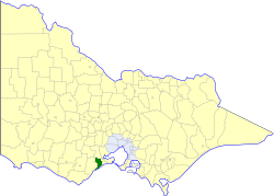
The Surf Coast Shire is a local government area in the Barwon South West region of Victoria, Australia, located in the south-western part of the state. It covers an area of 1,553 square kilometres (600 sq mi). It had a population of 32,251 in June 2018. It includes the towns of Aireys Inlet, Anglesea, Lorne, Moriac, Torquay and Winchelsea. It was formed in 1994 from the amalgamation of the Shire of Winchelsea, Shire of Barrabool and part of the former City of South Barwon, which was, at that point, part of the City of Greater Geelong.

<span class="mw-page-title-main">Grovedale, Victoria</span> Suburb of Geelong, Victoria, Australia

Grovedale is a southern suburb of Geelong, Victoria, Australia. At the 2021 census, Grovedale had a population of 14,869.

<span class="mw-page-title-main">Waurn Ponds, Victoria</span> Suburb of Geelong, Victoria, Australia

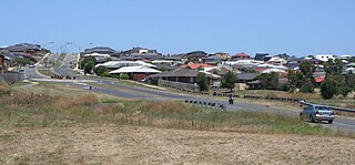
Waurn Ponds is a mainly residential southern suburb of Geelong, Victoria, Australia.

<span class="mw-page-title-main">Ceres, Victoria</span> Town in Victoria, Australia

Ceres is a locality of Geelong, Victoria, Australia. As one of the highest points in Geelong, Ceres has a lookout which overlooks the city. In the 2016 census, Ceres had a population of 254 people.

<span class="mw-page-title-main">Winchelsea, Victoria</span> Town in Victoria, Australia

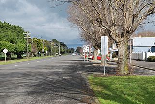
Winchelsea is a town in Victoria, Australia. The town is located in the Surf Coast Shire local government area, the suburb or locality of Winchelsea is predominantly within Surf Coast Shire with a small section within the Colac Otway Shire. Winchelsea is located on the Barwon River 115 km south-west of Melbourne and close to Geelong.

<span class="mw-page-title-main">Moriac, Victoria</span> Town in Victoria, Australia

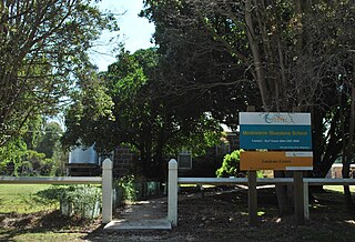
Moriac is a town in Victoria, Australia, located approximately 22 kilometres (14 mi) west of Geelong. It forms part of the Surf Coast Shire. At the 2016 census, Moriac had a population of 782. A Post Office opened on 1 August 1854 as Duneed, was renamed Mount Moriac in 1864, and Moriac in about 1909.

Connewarre is a locality in Victoria, Australia, is located in the City of Greater Geelong and Surf Coast Shire, and is named after Lake Connewarre which is situated immediately to its north-east. Connewarre is a version of "kunuwarra", the name of the black swan in the Wathawurrung language. At the 2016 census, Connewarre and the surrounding area had a population of 788.

<span class="mw-page-title-main">Beeac</span> Town in Victoria, Australia

Beeac is a town in the Western District of Victoria, Australia. The town is located on the shore of the hyper-saline Lake Beeac in the Colac Otway Shire local government area, 160 kilometres southwest of the state capital, Melbourne. At the 2016 census, Beeac had a population of 370.

<span class="mw-page-title-main">Shire of Barrabool</span> Local government area in Victoria, Australia

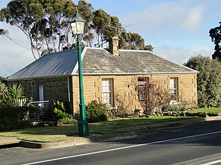
The Shire of Barrabool was a local government area about 100 kilometres (62 mi) southwest of Melbourne, the state capital of Victoria, Australia. The shire covered an area of 575.18 square kilometres (222.1 sq mi), and existed from 1853 until 1994.

The Barrabool Hills are a small region in south-Western Victoria, on the western outskirts of Geelong. The National Trust of Australia describes the hills as being a "distinctive upland ridge located to the west of Geelong, on the south side of the Barwon River", that "slope steeply on the northern side down to the Barwon River, and more gently southward to the coastal lowland." The area stretches roughly through the modern localities of Gnarwarre, Barrabool and Ceres, and straddles the intersection of the City of Greater Geelong, Surf Coast Shire and Golden Plains Shire.

Gherang is a small rural township in Victoria, Australia. It is in the Surf Coast Shire local government area, and is on the northern edge of the Great Otway National Park and the Anglesea Heath. At the 2006 census, Gherang had a population of 370. The area is mostly farmland, although there has been some rural-residential subdivision. Quarries in the area produce good quality gravel which is mostly used for roads.

<span class="mw-page-title-main">Modewarre</span> Suburb of Surf Coast Shire, Victoria, Australia

Modewarre is a locality in the Surf Coast Shire, Victoria, Australia. The town adjoins Lake Modewarre. In the 2016 census, Modewarre had a population of 276 people.

Wurdiboluc is a rural locality in the Surf Coast Shire, Victoria, Australia. In the 2016 census, Wurdiboluc had a population of 569 people.

Mount Moriac is a rural locality in the Surf Coast Shire, Victoria, Australia. In the 2016 census, Mount Moriac had a population of 240 people.

Paraparap is a rural locality in the Surf Coast Shire, Victoria, Australia. At the 2016 census, Paraparap had a population of 151 people.

Pennyroyal is a rural locality in Victoria, Australia. Most of the locality is situated in the Surf Coast Shire; a small section is situated in the Shire of Colac Otway. In the 2016 census, Pennyroyal had a population of 86.

Gnarwarre is a rural locality in the Surf Coast Shire, Victoria, Australia. In the 1800s, the locality was alternately known as Shankhill. In the 2016 census, Gnarwarre had a population of 267 people.

Benwerrin is a rural locality in the Surf Coast Shire, Victoria, Australia.

The Forrest railway line is a former branch railway in Victoria, Australia. It branched off the Warrnambool railway line at Birregurra, and ran through the foothills of the Otway Ranges to the town of Forrest.

Barrabool is a rural locality in the Surf Coast Shire, Victoria, Australia. In the 2016 census, Barrabool had a population of 235 people.

References

  1. 1 2 Australian Bureau of Statistics (28 June 2022). "Modewarre (SSC)". 2021 Census QuickStats. Retrieved 16 November 2017. OOjs UI icon edit-ltr-progressive.svg
  2. "Buckley (entry 100521)". VICNAMES. Government of Victoria . Retrieved 11 June 2014.
  3. Wynd, Ian (1992). Barrabool: Land of the Magpie. pp. 94–95. ISBN   0646089072.
  4. 1 2 3 Wynd 1992, p. 94-95.
  5. "Lake Town PO". Phoenix Auctions. Retrieved 4 February 2021.
  6. "Surf Coast Shire Heritage Study Stage 2B". Surfcoast Shire. Archived from the original on 4 March 2016. Retrieved 12 July 2014.
  7. Wynd 1992, p. 97.
  8. "Item Details". Public Record Office Victoria. Retrieved 11 June 2014.
  9. "Moriac 2031 Draft Structure Plan" (PDF). Surfcoast Shire. p. 37. Archived from the original (PDF) on 11 March 2014. Retrieved 18 June 2014.
  10. Wynd 1992, p. 94.
  11. "Buckley Station". Rail Geelong. Marcus Wong. Retrieved 11 March 2024.
  12. "Buckley". Phoenix Auctions. Retrieved 4 February 2021.
  13. "Sports Clubs". Surf Coast Shire. Retrieved 12 July 2014.
  14. "Erinvale Thoroughbreds". Archived from the original on 30 July 2014. Retrieved 12 July 2014.