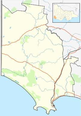
Cape Bridgewater is a locality in the Australian state of Victoria located on the western shore of Bridgewater Bay about 21 kilometres (13mi) south-west of Portland and about 383 kilometres (238mi) west of Melbourne.
The area was settled in the 1860s by the Henty family who had settled nearby Portland, and a post office opened in 1863 (closed 1968) though known as Bridgewater Lower for some years.[4]
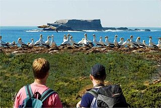
Cape Bridgewater is home to a colony of up to 650 fur seals and has the highest coastal cliff in Victoria. These cliffs are a suitable spot to observesouthern right whales in winter and spring. The cape itself also boasts a large blowhole and karst solution pipes, colloquially known as the petrified forest,[9] but now known to be hollow tubes of limestone, eroded as a result of millions of years of rainfall. Bridgewater Bay and the adjacent Cape form a partially submerged volcanic caldera. To the west is a large area with huge sand dunes. For these reasons the Cape and the nearby coastal area is classed by the government as the second most important coastline in Victoria, after the 'Twelve Apostles', along the Great Ocean Road
↑ Grant, James (1803), The narrative of a voyage of discovery, performed in His Majesty's vessel the Lady Nelson, London: Roworth, p.195, cited in Bird (2006)
↑ Lee, Ida (1915), The Logbooks of the Lady Nelson, London: Grafton, p.328, OL6580132M, cited in Bird (2006)
↑ Lipar, M., Webb, J. A., White, S.Q., Grimes, K.G., 2015. The genesis of solution pipes: Evidence from the Middle-Late Pleistocene Bridgewater Formation calcarenite, southeastern Australia. Geomorphology, 246, p. 90-103.
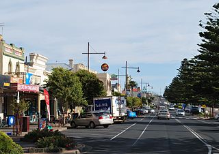
Portland is a city in Victoria, Australia, and is the oldest European settlement in the state. It is also the main urban centre in the Shire of Glenelg and is located on Portland Bay. In June 2018 the estimated population was 10,900, having decreased slowly at an average annual rate of −0.03% year-on-year over the preceding five years.
Cape Schanck is a locality in the Australian state of Victoria. It is the southernmost tip of the Mornington Peninsula and separates the wild ocean waters of Bass Strait from the slightly calmer waters of Western Port. At the 2016 Census, Cape Schanck had a population of 446.
His Majesty's Armed Survey Vessel Lady Nelson was commissioned in 1799 to survey the coast of Australia. At the time large parts of the Australian coast were unmapped and Britain had claimed only part of the continent. The British Government were concerned that, in the event of settlers of another European power becoming established in Australia, any future conflict in Europe would lead to a widening of the conflict into the southern hemisphere to the detriment of the trade that Britain sought to develop. It was against this background that Lady Nelson was chosen to survey and establish sovereignty over strategic parts of the continent.
Nelson is a small fishing town in Victoria, Australia on the lands of the Gunditjmara people. It is located at the mouth of the Glenelg River and Discovery Bay, a few kilometres from the South Australian border, and 422 kilometres (262 mi) west of Melbourne. At the 2016 census, Nelson and the surrounding area had a population of 190.
Cape Liptrap is located in south Gippsland, Victoria and is a peninsula that is the extension of the Hoddle Range that runs out to sea in a southwesterly direction. With a latitude of 38° 53' 60" S it the second most southerly point on the Australian mainland, just south of Cape Otway which lies to the west. Wilsons Promontory which is the most southerly point sits to the southeast separated from Cape Liptrap by Waratah Bay.
Port MacDonnell, originally known as Ngaranga is the southernmost town in South Australia. The small port located in the Limestone Coast region about 477 kilometres (296 mi) southeast of Adelaide and 28 kilometres (17 mi) south of Mount Gambier in the District Council of Grant local government area. The 2016 Australian census which was conducted in August 2016 reports that the locality of Port MacDonnell had a population of 847 of which 671 lived in its town centre. Once a busy shipping port, the town now relies heavily on its fishing and summer tourism industries, particularly rock lobster harvest industry, proclaiming itself "Australia's Southern Rock Lobster Capital".
Discovery Bay is an open oceanic embayment lying along the coast of eastern South Australia and western Victoria in south-eastern Australia.
Portland Bay is a small bay off the coast of Victoria, Australia. It is about 360 kilometres (220 mi) west of Melbourne. The main town on the bay is also named Portland. The western end of the bay is marked by the headland of Point Danger.
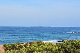
Lady Julia Percy Island, known as Deen Maar or Dhinmar in the Gunditjmara language, lies 8.1 kilometres (5.0 mi) off the coast, in the Barwon South West region of Victoria, Australia in Bass Strait. The island is an unincorporated area under the direct administration of the government of Victoria.
Cape Otway is a cape and a bounded locality of the Colac Otway Shire in southern Victoria, Australia on the Great Ocean Road; much of the area is enclosed in the Great Otway National Park.
Rodondo Island is a granite island, part of the Rodondo Group, lying in northern Bass Strait, within the state boundaries of Tasmania, Australia. The island is located only 10 kilometres (6.2 mi) south of Wilsons Promontory in Victoria, and 2' of latitude south of the Victoria-Tasmania border at latitude 39°12'S. Rodondo Island is ringed by steep cliffs up to 200 metres (660 ft) high, with an area of 106 hectares and a maximum elevation of 350 metres (1,150 ft) above sea level.
The Great South West Walk is a 251-kilometre (156 mi)/ 262-kilometer (163mi) walking track, established in 1981, located in South West Victoria, Australia. The track passes through the Lower Glenelg National Park, the Cobboboonee National Park, the Discovery Bay Coastal Park, the Mount Richmond National Park and the Cape Nelson State Park, and may be explored through shorter or overnight hikes, or the entire 12- to 14-day circular hike, starting and finishing in either Portland or Nelson. A short portion of the track is located with the Lower Glenelg River Conservation Park in South Australia, near Donovans.
Cape Spencer is a headland in the Australian state of South Australia located on the south west tip of Yorke Peninsula in the gazetted locality of Inneston. It was named after George Spencer, 2nd Earl Spencer by Matthew Flinders during March 1802. It has been the site of an operating navigation aid since 1950 and has been located within the Innes National Park since 1970.
Curtis Island is a granite island, with an area of 150 ha, in south-eastern Australia. It is part of Tasmania’s Curtis Group, lying in northern Bass Strait between the Furneaux Group and Wilsons Promontory in Victoria. It is a nature reserve and has been identified as an Important Bird Area because it supports up to 390,000 breeding pairs of short-tailed shearwaters or Tasmanian muttonbirds.
West Moncoeur Island is a granite island, ringed by steep cliffs, with an area of 9.18 ha, in south-eastern Australia. It is part of Tasmania’s Rodondo Group, lying in northern Bass Strait south of Wilsons Promontory in Victoria. It is a nature reserve.
The Cape Nelson State Park, near Portland on Victoria's southwest coast is a 243-hectare (600-acre) state park. Attractions include a 3-kilometre (2 mi) clifftop walk and a visit to the Cape Nelson lighthouse. The lighthouse was completed in 1884 and today offers accommodation in the Light Station Keepers Cottages. Part of the route of the Great South West Walk is located within the park.
The Lawrence Rocks are a group of two rocky islets, 6.8 ha and 1.5 ha in area, with an associated reef, 2.4 km south-east of Point Danger in western Victoria, Australia, and about 6 km south-east of the city of Portland. Geologically, the group is formed from the remnants of an extinct volcano, with the islets composed of basalt and tuff.
The Discovery Bay Coastal Park is a linear protected area of coastal land in western Victoria, south-eastern Australia. The 10,460-hectare (25,800-acre) park extends along the coast of Discovery Bay from Cape Nelson north-westwards for 50 kilometres (31 mi) to the border with South Australia. The park was listed on Australia's now-defunct Register of the National Estate, and lies within the traditional lands of the Gunditjmara people.
The Discovery Bay Marine National Park is a protected marine national park located in the Western District of Victoria, Australia The 2,770-hectare (6,800-acre) marine park is located near Portland, and extends along 6 kilometres (3.7 mi) of coastline on the western side of Cape Bridgewater, from Cape Duquesne to Blacks Beach, and offshore 3 nautical miles to the limit of Victorian waters.
Great Glennie Island is a small, rugged, granite island in the Glennie group of islands off the west coast of Wilsons Promontory, Victoria, Australia. It is part of the Wilsons Promontory Islands Important Bird Area, identified as such by BirdLife International because of its importance for breeding seabirds.
This page is based on this Wikipedia article Text is available under the CC BY-SA 4.0 license; additional terms may apply. Images, videos and audio are available under their respective licenses.