
The Great Ocean Road is an Australian National Heritage-listed 240-kilometre (150 mi) stretch of road along the south-eastern coast of Australia, between the Victorian towns of Torquay and Allansford. Built by returned soldiers between 1919 and 1932, and dedicated to soldiers killed during World War I, the road is the world's largest war memorial. Winding through varying terrain along the coast, and providing access to several prominent landmarks, including the Twelve Apostles limestone stack formations, the road is an important tourist attraction.

A natural arch, natural bridge, or rock arch is a natural landform where an arch has formed with an opening underneath. Natural arches commonly form where inland cliffs, coastal cliffs, fins or stacks are subject to erosion from the sea, rivers or weathering.
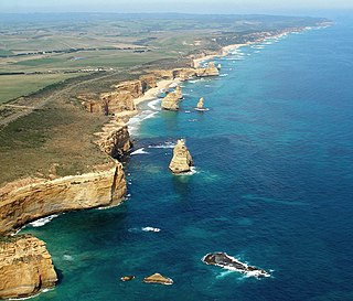
The Port Campbell National Park is a national park in the south-western district of Victoria, Australia. The 1,750-hectare (4,300-acre) national park is situated approximately 190 kilometres (120 mi) south-west of Melbourne and approximately 10 kilometres (6.2 mi) east of Warrnambool. The park is located adjacent to the Great Otway National Park and the Bay of Islands Coastal Park.

The Twelve Apostles are a collection of limestone stacks off the shore of Port Campbell National Park, by the Great Ocean Road in Victoria, Australia. The Twelve Apostles are located on the traditional lands of the Eastern Maar peoples.

The William Jolly Bridge is a heritage-listed road bridge over the Brisbane River between North Quay in the Brisbane central business district and Grey Street in South Brisbane, within City of Brisbane, Queensland, Australia. It was designed by Harding Frew and built from 1928 to 1932 by MR Hornibrook.

Peterborough is a town on the Great Ocean Road in Victoria, Australia, approximately three hours' drive from Melbourne. The town is situated on land to the west side of the mouth of the Curdies River.

The Barwon River is a perennial river of the Corangamite catchment, located in The Otways and the Bellarine Peninsula regions of the Australian state of Victoria.

The Gibson Steps are an area of cliffs on the south coast of Australia, located at 38°40′06″S143°06′43″E. The cliffs are the first sightseeing stopoff in Port Campbell National Park for travellers heading West along the Great Ocean Road, located about 2 minutes drive from The Twelve Apostles. The name Gibson Steps refers to the staircase leading down to the stretch of beach shown to the right.

The Loch Ard Gorge is part of Port Campbell National Park, Victoria, Australia, about three minutes' drive west of The Twelve Apostles.

Wicker Arches form a 660-yard (600 m) long railway viaduct across the Don Valley in the City of Sheffield, England. They take their name from the thoroughfare Wicker, which passes through the main arch of the viaduct and was, until the completion of the Sheffield Parkway, the main route eastwards from the city to the M1. It is a Grade II* listed structure.

Port Campbell is a coastal town in Victoria, Australia. The town is on the Great Ocean Road, west of the Twelve Apostles, in the Shire of Corangamite. At the 2016 census, Port Campbell had a population of 478.

The Grotto is a sinkhole geological formation and tourist attraction, found on the Great Ocean Road outside Port Campbell in Victoria, Australia. Wooden steps wind down the cliff face to the bottom, providing visibility of the sea beyond a pool at low tide.

Princes Bridge, originally Prince's Bridge, is a bridge in central Melbourne, Australia that spans the Yarra River. It is built on the site of one of the oldest river crossings in the city, and forms a gateway into the central city from the south. The bridge connects Swanston Street on the north bank of the Yarra River to St Kilda Road on the south bank, and carries road, tram and pedestrian traffic. The present bridge was built in 1888 and is listed on the Victorian Heritage Register.

The Great Ocean Walk is a walking trail on Victoria's southwest coast in Australia, traversing several areas of historical and cultural significance. The track makes extensive usage of eco-friendly facilities; with Parks Victoria and tour guide operators attempting to raise environmental awareness. The trail meanders along high cliff tops and sandy beaches.

Bay of Islands Coastal Park is a 32 kilometres long coastal reserve located in Victoria, Australia on the Great Ocean Road between Peterborough and Warrnambool. Lookout areas with parking are provided at the Bay of Martyrs, the Bay of Islands, Three Mile Beach and Childers Cove.

Lavers Hill is a town in Victoria, Australia, located 48 kilometres (30 mi) inland from Port Campbell and 48 kilometres (30 mi) from Apollo Bay. The township is located approximately 205 kilometres (127 mi) south-west of the state capital, Melbourne. At the 2016 census, Lavers Hill had a population of 78.
Princetown is a town in Victoria, Australia, located on the Great Ocean Road, east of the Twelve Apostles, in the Corangamite Shire.

The Twelve Apostles Marine National Park is a protected marine national park located on the south-west coast of Victoria, Australia. The 7,500-hectare (19,000-acre) marine park is situated near Port Campbell and is named after the scenic Twelve Apostles rock stacks, and contains the wreck of the clipper Loch Ard, wrecked on Mutton Bird Island in 1878. The marine park borders Port Campbell and Great Otway National Parks.
The Lansdowne Bridge is a heritage-listed road bridge that carries the northbound carriageway of the Hume Highway across Prospect Creek between Lansvale and Lansdowne. Situated in southwestern Sydney it is located on the boundary of the Fairfield and Canterbury-Bankstown local government areas. The bridge was named in honour of Henry Petty-Fitzmaurice, 3rd Marquess of Lansdowne (1780–1863), an Irish Whig politician of the British Parliament and associate of the NSW Governor of the day, Sir Richard Bourke.

The Island Archway was a 25 meter high, naturally formed rock arch that lay off Loch Ard Gorge, a bay on the south coast of Victoria, Australia. The gate collapsed on 10 June 2009. The arch of rock exposed in the water has been frequently photographed by the numerous international and domestic tourists vacationing in the Great Ocean Road area. The national and international press reported extensively on this geological event.

