
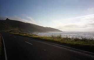
The Great Ocean Road is an Australian National Heritage listed 240-kilometre (150 mi) stretch of road along the south-eastern coast of Australia between the Victorian cities of Torquay and Allansford. Built by returned soldiers between 1919 and 1932 and dedicated to soldiers killed during World War I, the road is the world's largest war memorial. Winding through varying terrain along the coast and providing access to several prominent landmarks, including the Twelve Apostles limestone stack formations, the road is an important tourist attraction in the region. In December 2020, legislation went into effect to legally protect the Great Ocean Road – called the “Great Ocean Road Environs Protection Act 2020”.

Torquay is a seaside resort in Victoria, Australia, which faces Bass Strait, 21 km south of Geelong and is the gateway to the Great Ocean Road. It is bordered on the west by Spring Creek and its coastal features include Point Danger and Zeally Bay. At the 2016 census, Torquay had a population of 13,258.
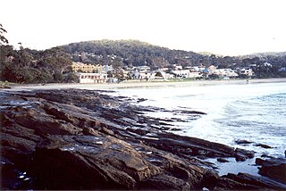
Lorne is a seaside town on Louttit Bay in Victoria, Australia. It is situated about the Erskine River and is a popular destination on the Great Ocean Road tourist route. Lorne is in the Surf Coast Shire and at the 2016 census had a population of 1,114 but this figure grows during the holiday season.

Anglesea is a town in Victoria, Australia. It is located on the Great Ocean Road in the Surf Coast Shire local government area. In the 2016 census, Anglesea had a population of 2,545 people.

Kennett River is a small seaside town in Victoria, Australia.

Wye River is a small town in Victoria, Australia. It is also the name given to the waterway which flows through the town and into the sea at this point. Situated some 155 km west of Melbourne, on the Otway Coast part of the scenic Great Ocean Road, the Wye River township is a popular tourist destination about 15 km west of the resort town of Lorne, Victoria. It became a popular place for Melburnians to holiday after the Great Ocean Road was officially opened in 1932. The postcode of Wye River is 3234. At the 2016 census, Wye River had a permanent population of 66 although its holiday population is ten times that number.
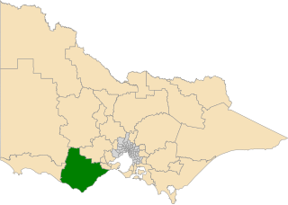
The electoral district of Polwarth is an electoral district of the Victorian Legislative Assembly. It is located in south-west rural Victoria, west of Geelong, and covers the Colac and Corangamite local government areas (LGA), parts of the Moyne, Golden Plains and Surf Coast LGAs, and slivers of the Ararat and Greater Geelong LGAs, running along the Great Ocean Road taking in Anglesea, Cape Otway, Peterborough, Aireys Inlet, Lorne, Wye River, Apollo Bay and Port Campbell, covering the inland towns of Winchelsea, Colac, Camperdown and Terang along the Princes Highway, and Inverleigh, Cressy, Lismore and Mortlake on the Hamilton Highway, and finally, includes the Otway Ranges and Lake Corangamite.

Surf Life Saving Australia (SLSA) is an Australian not-for-profit community organisation that promotes water safety and provides surf rescue services.
The Otway Coast comprises a popular beach and national park section of the Great Ocean Road on the south-eastern coast of Australia between the Victorian towns of Lorne and Apollo Bay. The townships on the Otway Coast are: Separation Creek, Wye River, Kennett River, Wongara and Sugarloaf.

The Aire River is a perennial river of the Corangamite catchment, located in The Otways region of the Australian state of Victoria.

The Cumberland River is a perennial river of the Corangamite catchment, located in The Otways region of the Australian state of Victoria.

The Erskine River is a river in southwestern Victoria, Australia. It arises in the Otway Ranges and enters Bass Strait to the east of Cape Otway through the town of Lorne. The Erskine River above the falls is known for its high diversity of native fish species and low occurrence of introduced species.
Big Hill is a coastal locality in the Surf Coast Shire, Victoria, Australia.
Eastern View is a locality in the Surf Coast Shire, Victoria, Australia.
Benwerrin is a rural locality in the Surf Coast Shire, Victoria, Australia.
Grey River is a rural locality in the Shire of Colac Otway, Victoria, Australia. It lies on the Great Ocean Road at the mouth of the Grey River, from which it derives its name.
Wongarra is a coastal locality in the Shire of Colac Otway, Victoria, Australia. In the 2016 census, Wongarra had a population of 37.
Sugarloaf is a small coastal locality in the Shire of Colac Otway, Victoria, Australia. In the 2011 census, the population of Sugarloaf was too low to separately report; however in November 2014 the Victorian Electoral Commission recorded 10 enrolled voters in Sugarloaf, living in 9 properties.
Petticoat Creek is a small coastal locality in the Shire of Colac Otway, Victoria, Australia. In the 2011 census, the population of Petticoat Creek was too low to report separately; however in November 2014 the Victorian Electoral Commission recorded two enrolled voters in Petticoat Creek, living in two properties.

The most destructive bushfire season in terms of property loss since the 2008–09 Australian bushfire season, occurred in the summer of 2015–16, with the loss of 408 houses and at least 500 non-residential buildings as a result of wild fires between 1 June 2015 and 31 May 2016. The season also suffered the most human fatalities since the 2008–09 Australian bushfire season; 6 died in Western Australia, 2 in South Australia and 1 in New South Wales. 8 deaths were as a direct result of fire, and a volunteer firefighter died due to unrelated health complications while on duty.
