
Colac is a town in the Western District of Victoria, Australia, approximately 150 kilometres south-west of Melbourne on the southern shore of Lake Colac.

The Shire of Colac Otway is a local government area in the Barwon South West region of Victoria, Australia, located in the south-western part of the state. It covers an area of 3,438 square kilometres (1,327 sq mi) and in June 2018 had a population of 21,503. It includes the towns of Apollo Bay, Beeac, Beech Forest, Birregurra, Colac, Cressy, Forrest, Johanna, Kennett River, Lavers Hill, Warrion and Wye River. It came into existence on 23 September 1994 through the amalgamation of the local government areas of City of Colac, Shire of Colac, part of the Shire of Otway and part of the Shire of Heytesbury.
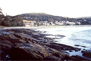
Lorne is a seaside town on Louttit Bay in Victoria, Australia. It is situated about the Erskine River and is a popular destination on the Great Ocean Road tourist route. Lorne is in the Surf Coast Shire and at the 2016 census had a population of 1,114 but this figure grows during the holiday season.

Apollo Bay is a coastal town in southwestern Victoria, Australia. It is situated on the eastern side of Cape Otway, along the edge of the Barham River and on the Great Ocean Road, in the Colac Otway Shire. The town had a population of 1,790 at the 2021 census.

Winchelsea is a town in Victoria, Australia. The town is located in the Surf Coast Shire local government area, the suburb or locality of Winchelsea is predominantly within Surf Coast Shire with a small section within the Colac Otway Shire. Winchelsea is located on the Barwon River 115 km south-west of Melbourne and close to Geelong.
Alvie is a small town in Victoria, Australia. It is located along Baynes Road, in the Colac Otway Shire, north-west of Colac. It was named after a Scottish town of the same name, which was the birthplace of James Macpherson Grant, the Minister of Lands. It is situated in what became a rich dairying, potato and onion growing area.

Camperdown is a town in southwestern Victoria, Australia, 190 kilometres (120 mi) west of the state capital, Melbourne. At the 2016 census, Camperdown had a population of 3,369.

Forrest is a small rural township in the Otway Ranges, Victoria, Australia. At the 2016 census, Forrest and the surrounding area had a population of 230.
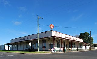
Lismore is a town in Victoria, Australia, located on the Hamilton Highway 170 kilometres (106 mi) west of Melbourne. It is part of the Corangamite Shire local government area. At the 2016 census, Lismore had a population of 420. Its Aboriginal name is cited in colonial reports as Bongerimennin.

Cressy is a town in Victoria, Australia, approximately 38 kilometres (24 mi) north of Colac on the Ballarat road. It is divided between Golden Plains Shire, the Shire of Colac Otway, and Corangamite Shire. At the 2016 census, Cressy and the surrounding area had a population of 175.

Birregurra, is a town in Colac Otway Shire, Victoria, Australia, approximately 130 kilometres (81 mi) south-west of Melbourne. At the 2021 census, it had a population of 942.

The Shire of Otway was a local government area about 190 kilometres (118 mi) southwest of Melbourne, the state capital of Victoria, Australia. The shire covered an area of 1,906.94 square kilometres (736.3 sq mi), and existed from 1919 until 1994.

The Colac & District Football Netball League (CDFNL) is a minor country football league based in the South West of Victoria in the city of Colac. The CDFNL has 10 clubs, all located in the Colac Otway Shire, with the exception of Lorne, which falls within the Surf Coast Shire. The competition incorporates the two sports of Australian rules football and netball.

Swan Marsh is a town in the Western District of Victoria, Australia. The town is located in the Colac Otway Shire local government area, 168 kilometres (104 mi) south west of the state capital, Melbourne.

Lake Beeac, a hypersaline endorheic lake, is located beside the small town of Beeac in the Lakes and Craters region of the Victorian Volcanic Plains of south-west Victoria, in southeastern Australia. The 560-hectare (1,400-acre) lake is situated about 19 kilometres (12 mi) northeast of Colac, and its high salinity gives it a milky-blue colour. The lake is part of the Ramsar-listed Western District Lakes site, and enjoys international recognition of its wetland values and some protection for its waterbirds.
Gellibrand is a town in south west Victoria, Australia. The town is located in the Otway Ranges midway between the Princes Highway and Great Ocean Road in the Colac Otway Shire, 176 kilometres (109 mi) south west of the state capital, Melbourne. At the 2016 census, Gellibrand had a population of 210. Gellibrand is home to the Otway Districts Demons Football and Netball Club, who play Australian Rules Football and participate in the Colac & District Football League.

The Irrewarra-Beeac Football Netball Club is an Australian rules football club which competes in the Colac & District Football League since 1986. They are based in the Victorian town of Irrewarra. Irrewarra is about six miles east of Colac.

The Colac Imperials Football Netball Club is an Australian rules football and netball club which competes in the Colac DFL since its founding in 1937.
Mount Moriac is a locality in the Surf Coast Shire, Victoria, Australia. In the 2016 census, Mount Moriac had a population of 240 people.
Norman Houghton is a historian and archivist in Geelong, Victoria, who has published more than 40 books, many focusing on timber tramways and sawmills of the Otway and Wombat Forests of Western Victoria, Australia. Most of his works have been self-published, while he has provided numerous articles to the newsletter and journal of the Light Railway Research Society of Australia.


