
Colac is a small city in the Western District of Victoria, Australia, approximately 150 kilometres south-west of Melbourne on the southern shore of Lake Colac.

The Shire of Colac Otway is a local government area in the Barwon South West region of Victoria, Australia, located in the south-western part of the state. It covers an area of 3,438 square kilometres (1,327 sq mi) and in June 2018 had a population of 21,503. It includes the towns of Apollo Bay, Beeac, Beech Forest, Birregurra, Colac, Cressy, Forrest, Johanna, Kennett River, Lavers Hill, Warrion and Wye River. It was formed in 1994 from the amalgamation of the City of Colac, Shire of Colac, Shire of Otway and part of the Shire of Heytesbury.

Lake Corangamite, a hypersaline endorheic lake, is located near Colac in the Lakes and Craters region of the Victorian Volcanic Plains of south-west Victoria, Australia. The lake's salinity levels have increased dramatically as the lake level has dropped in recent decades. It is Australia's largest permanent saline lake, covering approximately 230 square kilometres (89 sq mi) with a circumference of 150 kilometres (93 mi). It forms part of the Ramsar-listed Western District Lakes wetland site. The indigenous name of the lake is recorded as Kronimite.

Alvie is a small town in Victoria, Australia. It is located along Baynes Road, in the Colac Otway Shire, north-west of Colac. It was named after a Scottish town of the same name, which was the birthplace of James Macpherson Grant, the Minister of Lands. It is situated in what became a rich dairying, potato and onion growing area.

Warrion is a village in south west Victoria, Australia. Its buildings include a motor vehicle and farm equipment workshop, the Ti Tree Hotel, a church, a fire brigade station manned by volunteers and a community hall. Warrion sits at the foot of Warrion Hill. At the 2016 census, Warrion had a population of 198.

Colac railway station is located on the Warrnambool line in Victoria, Australia. It serves the town of Colac, and opened on 27 July 1877, as the terminus of the line from Birregurra. On 2 July 1883, the line was extended to Camperdown.
Cape Otway is a cape and a bounded locality of the Colac Otway Shire in southern Victoria, Australia on the Great Ocean Road; much of the area is enclosed in the Great Otway National Park.

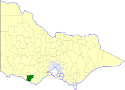
The Electoral district of Colac was an electoral district of the Victorian Legislative Assembly, one of the inaugural districts of the first Assembly in 1856.

The Shire of Colac was a local government area about 150 kilometres (93 mi) west-southwest of Melbourne, the state capital of Victoria, Australia. The shire covered an area of 1,458.2 square kilometres (563.0 sq mi), and existed from 1859 until 1994.

The Shire of Hampden was a local government area about 200 kilometres (124 mi) west-southwest of Melbourne, the state capital of Victoria, Australia. The shire covered an area of 2,620.91 square kilometres (1,011.9 sq mi), and existed from 1857 until 1994.
The Shire of Heytesbury was a local government area about 200 kilometres (124 mi) west-southwest of Melbourne, the state capital of Victoria, Australia. The shire covered an area of 1,558.39 square kilometres (601.7 sq mi), and existed from 1895 until 1994.

The Shire of Otway was a local government area about 190 kilometres (118 mi) southwest of Melbourne, the state capital of Victoria, Australia. The shire covered an area of 1,906.94 square kilometres (736.3 sq mi), and existed from 1919 until 1994.

The City of Colac was a local government area about 150 kilometres (93 mi) west-southwest of Melbourne, the state capital of Victoria, Australia. The city covered an area of 10.88 square kilometres (4.2 sq mi), and existed from 1938 until 1994. Its area was surrounded by the separate and largely rural Shire of Colac.

The Warrnambool railway line is a railway serving the south west of Victoria, Australia. Running from the western Melbourne suburb of Newport through the cities of Geelong and Warrnambool, the line once terminated at the coastal town of Port Fairy before being truncated to Dennington. This closed section of line has been converted into the 37 km long Port Fairy to Warrnambool Rail Trail. The line continues to see both passenger and freight services today.

Dundas was a historical mining locality, mineral field and railway location on the western foothills of the West Coast Range in Western Tasmania. It is now part of the locality of Zeehan.
Robert Guyon Whittlesey Purchas was an Australian architect, especially noted as a pioneer of the Arts & Crafts style seen in a number of large residential projects in the late 1890s and early 1900s. He was the son of prominent architect, civil engineer, and surveyor, Albert Purchas.

Mount Moriac is a rural locality in the Surf Coast Shire, Victoria, Australia. In the 2016 census, Mount Moriac had a population of 240 people.
Norman Houghton is a historian and archivist in Geelong, Victoria, who has published over 30 books, many focusing on timber tramways and sawmills of the Otway and Wombat Forests of Western Victoria, Australia. Most of his works have been self-published, while he has provided numerous articles to the newsletter and journal of the Light Railway Research Society of Australia
John Haimes was pioneer mail coach operator, hotelier and brewer in South Australia, and pastoralist and racehorse breeder and owner in Victoria, Australia, where he was universally known as "Captain Haimes".
Russell Mervyn Murray, commonly referred to as R. M. Murray, was general manager of the Mount Lyell Mining and Railway Co. Ltd, Queenstown, Tasmania for 22 years. Unusually for a mining man, his entire career of 44 years was spent at one location and for one company.
