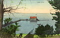
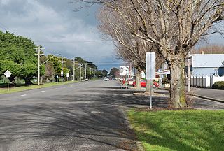
Colac is a small city in the Western District of Victoria, Australia, approximately 150 kilometres south-west of Melbourne on the southern shore of Lake Colac.

The Avoca River, an inland intermittent river of the north–central catchment, part of the Murray-Darling basin, is located in the lower Riverina bioregion and Central Highlands and Wimmera regions of the Australian state of Victoria. The headwaters of the Avoca River rise on the northern slopes of the Pyrenees Range and descend to flow into the ephemeral Kerang Lakes.

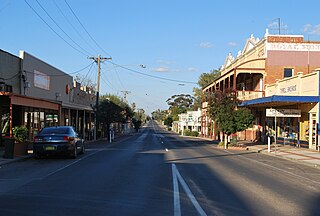
Edenhope is a town in Victoria, Australia. It is located on the Wimmera Highway, 30 kilometres from the South Australian border, in the Shire of West Wimmera local government area. At the 2016 census Edenhope had a population of 946.
Lake Corangamite, a hypersaline endorheic lake, is located near Colac in the Lakes and Craters region of the Victorian Volcanic Plains of south-west Victoria, Australia. The lake's salinity levels have increased dramatically as the lake level has dropped in recent decades. It is Australia's largest permanent saline lake, covering approximately 230 square kilometres (89 sq mi) with a circumference of 150 kilometres (93 mi). It forms part of the Ramsar-listed Western District Lakes wetland site. The Aboriginal name of the lake is recorded as Kronimite.

Lake Hāmūn, or the Hamoun Oasis, is a seasonal lake and wetlands in the endorheic Sīstān Basin in the Sistan region on the Afghanistan–Iran border. In Iran, it is also known as Hāmūn-e Helmand, Hāmūn-e Hīrmand, or Daryācheh-ye Sīstān.

Lake Wendouree is an artificially created and maintained shallow urban lake located adjacent to the suburb of the same name in the city of Ballarat, Victoria, Australia. The name Wendouree comes from a local Aboriginal word wendaaree which means 'go away': a story is told that when settler William Cross Yuille asked a local Indigenous woman what the name of the swamp was, that was her reply.
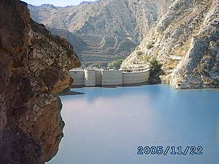
Namal Lake is located near Rikhi, a village on one corner of the Namal valley in Mianwali District, Punjab, Pakistan. It was formed following the construction of Namal Dam in 1913. Namal Dam is situated some 32 km (20 mi) from Mianwali city. The lake has a surface area of 5.5 km2 (2.1 sq mi). There are mountains on its western and southern sides. On the other two sides are agricultural areas.
Sea Lake is a town in the Mallee district of north-west Victoria, Australia and is situated on the southern shores of Lake Tyrrell. The town is located on the Calder Highway, 351 kilometres (218 mi) north-west of Melbourne, and 73 kilometres (45 mi) west of Swan Hill. Sea Lake is in the heart of Australia's wheat belt, and is the main township for a number of wheat farms in the region. At the 2021 census, Sea Lake had a population of 619.

Drought in Australia is defined by the Australian Bureau of Meteorology as rainfall over period greater than three-months being in the lowest decile of what has been recorded for that region in the past. This definition takes into account that drought is a relative term and rainfall deficiencies need to be compared to typical rainfall patterns including seasonal variations. Specifically, drought in Australia is defined in relation to a rainfall deficiency of pastoral leases and is determined by decile analysis applied to a certain area. Note that this definition uses rainfall only because long-term records are widely available across most of Australia. However, it does not take into account other variables that might be important for establishing surface water balance, such as evaporation and condensation.

Lake Boga is a town in Victoria, Australia, located next to the lake of the same name. It is situated within the Rural City of Swan Hill within the Mallee region of north-west Victoria. At the 2016 census, Lake Boga had a population of 985. The town is located 325 kilometres (202 mi) north west of Melbourne and 17 kilometres (11 mi) south east of the regional centre Swan Hill.

Lake Tyrrell is a shallow, salt-crusted depression in the Mallee district of north-west Victoria, in Australia. The name 'Tyrrell' is derived from the local Wergaia word for 'sky', the Boorong Aboriginal people of the area being distinguished for their interest in star-lore. The Boorong, with their astronomical traditions, told stories connected with constellations in the night sky.
Beeac is a town in the Western District of Victoria, Australia. The town is located on the shore of the hyper-saline Lake Beeac in the Colac Otway Shire local government area, 160 kilometres southwest of the state capital, Melbourne. At the 2016 census, Beeac had a population of 370.
Lake Burrumbeet is a large but shallow eutrophic lake in central western Victoria, Australia. Located 20 kilometres (12 mi) west of Ballarat and 140 kilometres (87 mi) west of Melbourne, the lake has been progressively emptying since 1997 and was declared completely dry in 2004. It has however in recent years refilled because of good rainfalls, making water sports in the lake once again possible, with recreational jet skiing and boating taking place in the winter of 2010. The lake is a major wetland for the region because of its size and is utilised as a recreational area for boating, fishing and camping.
Lake Gore is a seasonal and semi-permanent freshwater lake in the Goldfields-Esperance region of Western Australia located approximately 24 km (15 mi) west of Esperance. It is an important site for waterbirds.
The 2000s drought in Australia, also known as the Millennium drought is said by some to be the worst drought recorded since European settlement.

Reedy Lake, historically also known as Lake Reedy, is a shallow 5.5-square-kilometre (2.1 sq mi) intermittent freshwater lake or swamp on the lower reaches of the Barwon River, on the Bellarine Peninsula southeast of Geelong in the Australian state of Victoria.

Lake Beeac, a hypersaline endorheic lake, is located beside the small town of Beeac in the Lakes and Craters region of the Victorian Volcanic Plains of south-west Victoria, in southeastern Australia. The 560-hectare (1,400-acre) lake is situated about 19 kilometres (12 mi) northeast of Colac, and its high salinity gives it a milky-blue colour. The lake is part of the Ramsar-listed Western District Lakes site, and enjoys international recognition of its wetland values and some protection for its waterbirds.
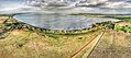
Lake Hindmarsh, an ephemeral lake located in the Wimmera region of western Victoria, Australia, is the state's largest natural freshwater lake. The nearest towns are Jeparit to the south and Rainbow to the north. After more than a decade of drought, in early 2011 the lake filled as a result of flooding in the region. The Wemba Wemba name of the lake is recorded as Gour or Koor.
Chowilla Regional Reserve is protected area in the Australian state of South Australia located in the gazetted locality of Chowilla about 250 kilometres (160 mi) north-east of the state capital of Adelaide.

The historical and ongoing droughts in California result from various complex meteorological phenomena, some of which are not fully understood by scientists.