Lake Lorne

Last updated

Lake Lorne
Lake Lorne 03.jpg
Australia Victoria relief location map.jpg
Red pog.svg
Lake Lorne
Location in Victoria
Location Bellarine Peninsula, Victoria
Coordinates 38°10′55″S144°33′29″E / 38.18194°S 144.55806°E / -38.18194; 144.55806 [1]
Type Freshwater
Basin  countriesAustralia
Surface area12 ha (30 acres)
Surface elevation62 m (203 ft)
View across lake to Drysdale Railway Station. Lake Lorne 04.jpg
View across lake to Drysdale Railway Station.

Lake Lorne, a small 12-hectare (30-acre) freshwater lake on the Bellarine Peninsula, Victoria, Australia, is located immediately south-west of the township of Drysdale.

Contents

Location and features

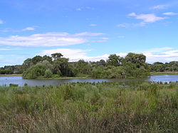
The lake is a popular birdwatching site and is well known for its variety of waterbirds, many of which have been recorded as breeding there. Lake Lorne lies in a depression in the underlying limestone and has no surface outlet. Water levels may vary substantially, often with a lag time in response to rainfall, with the nearby McLeods Waterholes being part of the same hydrological system. It contains a central complex of three islets densely vegetated with willows, eucalypts, paperbarks and pittosporums. The lake is largely surrounded by parkland and is close to the Drysdale railway station.

Birds

The lake is important for freckled and blue-billed ducks which are listed as threatened in Victoria. Waterbirds, waders and rails which have bred at the lake include black swans, hardheads, musk ducks, Australasian and hoary-headed grebes, darters, little pied and little black cormorants, dusky moorhens, purple swamphens, Eurasian coots and black-fronted dotterels. It is also a roosting site for hundreds of cormorants and ibises. [2] [3]

Related Research Articles

<span class="mw-page-title-main">Little pied cormorant</span> Species of bird

The little pied cormorant, little shag or kawaupaka is a common Australasian waterbird, found around the coasts, islands, estuaries, and inland waters of Australia, New Guinea, New Zealand, Timor-Leste, and Indonesia, and around the islands of the south-western Pacific and the subantarctic. It is a small short-billed cormorant usually black above and white below with a yellow bill and small crest, although a mostly black white-throated form predominates in New Zealand. Three subspecies are recognised. Until recently most authorities referred to this species as Phalacrocorax melanoleucos.

<span class="mw-page-title-main">Great cormorant</span> Species of bird

The great cormorant, known as the black shag or kawau in New Zealand, formerly also known as the great black cormorant across the Northern Hemisphere, the black cormorant in Australia, and the large cormorant in India, is a widespread member of the cormorant family of seabirds. The genus name is Latinised Ancient Greek, from φαλακρός and κόραξ, and carbo is Latin for "charcoal".

<span class="mw-page-title-main">Drysdale, Victoria</span> Town in Victoria, Australia

Drysdale is a rural township near Geelong, Victoria, Australia, located on the Bellarine Peninsula. The town has an approximate population of over 3,700. Drysdale forms part of an urban area, along with nearby Clifton Springs, that had an estimated population of 13,494 at June 2016.

<span class="mw-page-title-main">Bellarine Peninsula</span> Peninsula in Victoria, Australia

The Bellarine Peninsula is a peninsula located south-west of Melbourne in Victoria, Australia, surrounded by Port Phillip, Corio Bay and Bass Strait. The peninsula, together with the Mornington Peninsula, separates Port Phillip Bay from Bass Strait. The peninsula itself was originally occupied by Indigenous Australian clans of the Wadawurrung nation, prior to European settlement in the early 19th century. Early European settlements were initially centred on wheat and grain agriculture, before the area became a popular tourist destination with most visitors arriving by paddle steamer on Port Phillip in the late 19th century.

<span class="mw-page-title-main">Little black cormorant</span> Species of bird

The little black cormorant is a member of the cormorant family of seabirds. It is common in smaller rivers and lakes throughout most areas of Australia and northern New Zealand, where it is known as the little black shag. It is around sixty centimetres long, and is all black with blue-green eyes.

<span class="mw-page-title-main">Black-faced cormorant</span> Species of bird

The black-faced cormorant, also known as the black-faced shag, is a medium-sized member of the cormorant family. Upperparts, including facial skin and bill, are black, with white underparts. It is endemic to coastal regions of southern Australia.

<span class="mw-page-title-main">Lake Victoria (Victoria)</span> Lake in Victoria, Australia

Lake Victoria is a 139-hectare (340-acre) shallow saline lake on the Bellarine Peninsula, Victoria in Australia, close to the township of Point Lonsdale and part of the Lonsdale Lakes Nature Reserve administered by Parks Victoria.

<span class="mw-page-title-main">Red-legged cormorant</span> Species of bird

The red-legged cormorant, also known as the red-legged shag, red-footed cormorant, red-footed shag, Gaimard's cormorant and grey cormorant, is a species of cormorant resident to the coastline of South America. It is the only member of the genus Poikilocarbo. It is non-colonial unlike most seabirds. The red-legged cormorant has not been observed wing-spreading, which is unusual among cormorant species.

<span class="mw-page-title-main">Lake Connewarre</span> Estuarine lake in Victoria, Australia

Lake Connewarre, a shallow estuarine 880-hectare (2,200-acre) lake on the Barwon River, is located on the Bellarine Peninsula southeast of Geelong in the Australian state of Victoria.

<span class="mw-page-title-main">Ocean Grove Nature Reserve</span> Protected area in Victoria, Australia

The Ocean Grove Nature Reserve is a rectangular, 1.43 km2 nature reserve next to the town of Ocean Grove and 25 km south-east of the city of Geelong, on the Bellarine Peninsula, Victoria, Australia. It contains the only significant remnant of native woodland on the Bellarine Peninsula as it was prior to European settlement and the extensive land clearing that ensued. It is surrounded by agricultural land and a housing estate and is managed by Parks Victoria. Records of its birdlife illustrate the changes occurring in an isolated woodland remnant.

<span class="mw-page-title-main">Reedy Lake</span> Lake or swamp in Victoria, Australia

Reedy Lake, historically also known as Lake Reedy, is a shallow 5.5-square-kilometre (2.1 sq mi) intermittent freshwater lake or swamp on the lower reaches of the Barwon River, on the Bellarine Peninsula southeast of Geelong in the Australian state of Victoria.

<span class="mw-page-title-main">Goyder Lagoon</span> Salt lake in Clifton Hills Station, South Australia

The Goyder Lagoon is a large ephemeral swamp in the Australian state of South Australia in the state's Far North region. The lake is part of the Diamantina River floodplain, lying beside the Birdsville Track close to the state border with Queensland.

<span class="mw-page-title-main">Western District Lakes</span> Wetlands in south-eastern Australia

The Western District Lakes of Victoria, in the Western District of Victoria, south-eastern Australia, were recognised on 15 December 1982 as wetlands of international importance by listing under the Ramsar Convention, as Ramsar site no.268.

<span class="mw-page-title-main">Lake Machattie Area</span>

The Lake Machattie Area is a 909 km2 tract of land comprising Lakes Machattie, Mipia and Koolivoo, with the surrounding Georgina River and Eyre Creek floodplains, in the arid Channel Country of western Queensland, Australia. The area is important as a breeding site for waterbirds.

<span class="mw-page-title-main">Legune (Joseph Bonaparte Bay) Important Bird Area</span>

The Legune Important Bird Area comprises a low-lying, swampy, floodplain peninsula at the south-eastern end of the Joseph Bonaparte Gulf in the Top End of the Northern Territory of Australia. The land is part of the Legune Station, a cattle station and pastoral lease.

<span class="mw-page-title-main">Narran Wetlands</span> Protected area in New South Wales, Australia

The Narran Wetlands, also known as the Narran Lakes, contained within the Narran Lake Nature Reserve, comprise a series of protected ephemeral lakes and swamps fed by the Narran River in the north-west of New South Wales, Australia. The 26,480-hectare (65,400-acre) reserve is located approximately 50 kilometres (31 mi) east of Brewarrina.

<span class="mw-page-title-main">Werribee and Avalon Important Bird Area</span>

The Werribee and Avalon Important Bird Area comprises some 37 km2 of coastal land along the northwestern shore of Port Phillip in the state of Victoria, in southeastern Australia. It is important for a wide variety of waterbirds.

<span class="mw-page-title-main">Yalgorup Important Bird Area</span> Important Bird Area in Western Australia

The Yalgorup Important Bird Area comprises a group of parallel, linear wetlands, with a collective area of 59 km2, on the Swan Coastal Plain of south-west Western Australia between the cities of Mandurah and Bunbury. It is an important site for waterbirds.

<span class="mw-page-title-main">Fog Bay and Finniss River Floodplains</span> Floodplain in the Northern Territory of Australia

The Fog Bay and Finniss River Floodplains comprise the floodplain of the lower reaches of the Finniss River with the adjoining intertidal mudflats of Fog Bay in the Top End of the Northern Territory of Australia. It is an important site for waterbirds.

References

  1. "Lake Lorne". Vicnames. Government of Victoria. 2 May 1966. Archived from the original on 6 June 2014. Retrieved 4 June 2014.
  2. Hewish, Marilyn (2002). "New information on the birds of Lake Lorne, Drysdale, 1997-2002". Geelong Bird Report. 2001: 89–95. ISSN   1323-2681.
  3. King, Dave; Cameron, Margaret (1997). "The birds of Lake Lorne, Drysdale". Geelong Bird Report. 1996: 32–39. ISSN   1323-2681.