Koomba Park

Last updated

Koomba Park
Koomba Park Southern Entrance.jpg
The southern vehicle entrance to Koomba Park
Koomba Park
Type Metropolitan Park
Location Wantirna, Victoria, Australia
Coordinates 37°51′09″S145°12′43″E / 37.8525°S 145.2119°E / -37.8525; 145.2119
Area92 hectares (230 acres) [1]
(33 hectares open to public)
CreatedDecember 1981
Operated by Parks Victoria and VicRoads
StatusOpen all year
Dandenong Creek Trail Koomba Park.jpg
Koomba Park trail.jpg
The Dandenong Creek Trail and EastLink Trail run along this section of path in the north of the park (looking south towards Burwood Highway)

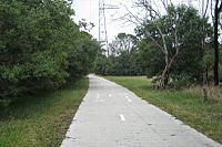
Koomba Park is one of the parks comprising the Dandenong Valley Parklands in the eastern suburbs of Melbourne, Australia. It consists of 92 hectares (230 acres) of which 33 hectares (82 acres) are publicly accessible, and is bounded by Dandenong Creek, Boronia Road, EastLink, Mountain Highway and Burwood Highway in a clockwise direction. It is managed primarily by VicRoads and Parks Victoria. [2] The park opened in December 1981, and its land was previously used for cattle grazing and apple orchards. [1] The surrounding area is still used for grazing. [3] There are three major power transmission lines running through the park: Rowville-Templestowe Single Circuit Southern (first and second), and Rowville-Ringwood. [4]

Contents

In 2019, a study found that Koomba Park was one of the least used areas of the Dandenong Valley Parklands, and also garnered the least satisfaction from park users when compared to Jells Park and Tirhatuan Park. [5]

Ecology

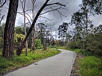
The park forms part of the wildlife corridor of Dandenong Creek, and contains a large amount of riparian forest, as well as wetlands and swamps and some areas of indigenous revegetation. [6] Common mammals in the park include various species of bats, possums, and sugar gliders. [1] There is a bird hide adjacent to one of the ponds, from which many species of native birds are observable. [7] The park also provides habitat to a variety of indigenous plant species, many of which are threatened or endangered. [2] Koomba Park has several man-made water bodies, and is classified in the Urban Floodway Zone since it is prone to inundation. [8] [9]

Paths and trails

Cycle paths

Both Dandenong Creek Trail and EastLink Trail run through the park on the primary north–south concrete path, before the trails split near the southern car park. [10] All trails were originally of fine crushed gravel, but in mid-late 2007, the existing Dandenong Creek Trail was upgraded to 3-metre (9.8 ft) wide concrete bike path from Boronia Road south to the former toilet block as part of the construction of EastLink. A new path of the same standard was constructed which leads further south to the Mountain Highway intersection with Burwood Highway, which forms part of the EastLink Trail, opened in mid-2008. [11] The primary path exit at the north of the park leads under Boronia Road and continues to run alongside the Dandenong Creek while the southern path (the EastLink Trail) leads further along EastLink to the south, and the southwest path (the Dandenong Creek Trail) crosses the Dandenong Creek and meets the Burwood Highway in Vermont South, with this link being constructed as a boardwalk and opened in 1997. [1]

Koomba Park constitutes part of the Opperman Trails, a tribute to cyclist Sir Hubert Opperman. [12] The Lands End Trail is signposted through the park, including an information board about Opperman.

Walking paths

There are a number of gravel walking paths on the eastern side of Dandenong Creek.

There is an elevated boardwalk winding southwesterly through the Dandenong Creek wetlands, serving as a section of the Dandenong Creek Trail. In 2023, the Koomba Park Boardwalk was closed to public access "for the foreseeable future" due to "ongoing safety concerns".[ citation needed ]

Facilities

Koomba Park has a large carpark at the southern end, on a service road off Mountain Highway, which is shared with Wantirna Reserve. [1] There is another smaller carpark at the northern end off Boronia Road. [13] A joint picnic shelter and toilet block (which was originally a sports pavilion) existed in the park for some time, but was demolished in mid-2008 due to numerous crime incidents (see § Incidents). [14] Electric barbecues were also removed at the same time. Information boards are located at the north and south pedestrian entrances to the park. [1] A drinking fountain is also located at the junction of Dandenong Creek Trail and EastLink Trail.

Wantirna Reserve

The adjoining Wantirna Reserve, managed by Knox City Council and located at the southern end of the park, features a sporting oval with an adjacent clubhouse and cricket nets which caters for Australian rules football and cricket. [15] The reserve also contains the Wantirna Tennis Club, as well as a scout hall and playground. All facilities are accessed by dirt roads with parking areas provided. The Victorian Jazz Archive is also located on the left side of the southern entrance to Koomba Park.

Incidents

The park is known by locals and the Victoria Police to be a meeting point for drug deals and gay sex, due to its remoteness from residential areas and densely wooded forests, especially at night. [16] There have been several attempts to decrease criminal activity in the park, including regular patrolling. [17] In 2006, the male toilets were permanently closed in a bid to curb gay sex meetings. In late 2008, the entire toilet block/picnic shelter was demolished in a further effort. [14]

On 7 May 2010 at approximately 1 am, a drug deal in the park lead to the stabbing murder of a 41-year-old man from Dandenong. [18]

In 2010, a 50-year-old man fell from an elevated boardwalk in Koomba Park whilst cycling, suffering fatal injuries. [19] [20]

Related Research Articles

<span class="mw-page-title-main">EastLink (Melbourne)</span> Tollway in Melbourne, Australia

EastLink is a tolled section of the M3 freeway linking a large area through the eastern and south-eastern suburbs of Melbourne, Australia.

<span class="mw-page-title-main">Ferntree Gully, Victoria</span> Suburb of Melbourne, Victoria, Australia

Ferntree Gully is a suburb in Melbourne, Victoria, Australia, at the foothills of the Dandenong Ranges, 27 km east of Melbourne's Central Business District, located within the City of Knox local government area. Ferntree Gully recorded a population of 27,398 at the 2021 census.

Wantirna is a suburb in Melbourne, Victoria, Australia, 27 km east of Melbourne's Central Business District, located within the City of Knox local government area. Wantirna recorded a population of 14,237 at the 2021 census.

<span class="mw-page-title-main">Vermont South, Victoria</span> Suburb of Melbourne, Victoria, Australia

Vermont South is a suburb of Melbourne, Australia, 26 km east of its Central Business District. It had a population of 11,954 at the 2021 census.

<span class="mw-page-title-main">Upwey, Victoria</span> Suburb of Melbourne, Victoria, Australia

Upwey is a suburb of Melbourne, Victoria, Australia, 33 kilometres (21 mi) east from Melbourne's central business district, located within the City of Knox and the Shire of Yarra Ranges local government areas. Upwey recorded a population of 6,818 at the 2021 census.

<span class="mw-page-title-main">Dandenong Valley Highway</span>

The Dandenong Valley Highway is an urban highway stretching almost 40 kilometres from Bayswater in Melbourne's eastern suburbs to Frankston in the south. This name covers many consecutive streets and is not widely known to most drivers, as the entire allocation is still best known as by the names of its constituent parts: Stud Road, Foster Street, Dandenong-Frankston Road, Dandenong Road West and Fletcher Road. This article will deal with the entire length of the corridor for sake of completion, as well to avoid confusion between declarations.

<span class="mw-page-title-main">Parks and gardens of Melbourne</span> Parks and gardens in Melbourne, VIC, Australia

Melbourne is Australia's second largest city and widely considered to be a garden city, with Victoria being nicknamed "the Garden State". Renowned as one of the most livable cities in the world, there is an abundance of parks, gardens and green belts close to the CBD with a variety of common and rare plant species amid landscaped vistas, pedestrian pathways, and tree-lined avenues, all managed by Parks Victoria.

<span class="mw-page-title-main">Mountain Highway</span> Highway in Victoria, Australia

Mountain Highway is an 18 km west–east highway located in the eastern suburbs of Melbourne, linking the outer fringes of the city to the Dandenong Ranges.

The Eastern Football Netball League is an Australian rules football league, based in the eastern suburbs of metropolitan Melbourne.

<span class="mw-page-title-main">Dandenong Creek Trail</span> Suburban trail in Melbourne, Australia

The Dandenong Creek Trail is a shared use path for cyclists and pedestrians, which follows Dandenong Creek through the outer eastern and south-eastern suburbs of Melbourne, Victoria, Australia.

<span class="mw-page-title-main">Jells Park</span>

Jells Park is a public park in Wheelers Hill, a southeastern suburb of Melbourne, Victoria, Australia. The park opened on 30 April 1976 and is named after Joseph Jell, a cattle grazier who worked in the area in the mid-late 1800s. The park attracts in excess of 900,000 visitors a year.

<span class="mw-page-title-main">Dandenong Creek</span> Urban creek in Melbourne, Australia

The Dandenong Creek is an urban creek of the Port Phillip catchment, located in the eastern and south-eastern Greater Melbourne region of the Australian east coast state of Victoria. The creek descends approximately 550 metres (1,800 ft) over its course of 53 kilometres (33 mi) before joining the Eumemmerring Creek to form the Patterson River and eventually draining into the Beaumaris Bay.

<span class="mw-page-title-main">Outer Circle Trail</span>

The Outer Circle Trail, also known as the Anniversary Trail, is a shared use path for cyclists and pedestrians, which partly follows the Alamein Line through the inner eastern suburbs of Melbourne, Victoria, Australia.

<span class="mw-page-title-main">Scotchmans Creek Trail</span>

The Scotchmans Creek Trail is a shared use path for cyclists and pedestrians, which follows Scotchmans Creek through the eastern suburbs of Melbourne, Victoria, Australia.

<span class="mw-page-title-main">Blind Creek Trail</span>

The Blind Creek Trail, in the outer eastern suburbs of Melbourne, in the Australian state of Victoria, is a shared-use path for cyclists and pedestrians, which follows the Blind Creek from the Dandenong Creek Trail in Wantirna South to the Ringwood - Belgrave Rail Trail in Boronia.

<span class="mw-page-title-main">Ringwood to Belgrave Rail Trail</span> Rail trail in Victoria, Australia

The Ringwood - Belgrave Rail Trail is a shared use path for cyclists and pedestrians, which follows the Belgrave railway line from the Mullum Mullum Creek Trail in Ringwood to Belgrave railway station in Belgrave, in the outer eastern suburbs of Melbourne, Victoria, Australia.

<span class="mw-page-title-main">Ferny Creek Trail</span>

The Ferny Creek Trail is a shared use path for cyclists and pedestrians, which follows Ferny and Corhanwarrabul Creeks through the suburbs of Knoxfield and Ferntree Gully in Melbourne, Victoria, Australia.

<span class="mw-page-title-main">Lakes and reservoirs of Melbourne</span>

Melbourne is the capital city of southeastern Australian state of Victoria and also the nation's second most populous city, and has been consistently voted one of the most liveable cities in the world. Located on the northern/eastern coastal plains of Port Phillip Bay, the city is one of the drier capital cities in Australia, but due to its relatively flat terrain and the runoffs fed from surrounding highlands, still has many lakes, ponds and wetlands, mainly managed by Melbourne Water and Parks Victoria. The larger waterbodies are used for water sports, mostly boating but some are used for recreational activities like swimming, water skiing or model boating.

<span class="mw-page-title-main">EastLink Trail</span> Suburban trail in Melbourne, Australia

The EastLink Trail is a shared use path for cyclists and pedestrians in the outer eastern/southeastern suburbs of Melbourne, Victoria, Australia. The trail gets its name from the north-south EastLink tollway, along which it follows for most of its length from Ringwood to Dandenong, until it joins the Dandenong Creek Trail near the Dandenong Bypass bridge at the tri-suburban junction between Dandenong, Dandenong South and Keysborough.

<span class="mw-page-title-main">Dandenong Valley Parklands</span> Public parks in south east Melbourne, Victoria, Australia

The Dandenong Valley Parklands are a collection of public parks and open space reserves along the Dandenong Creek, an urban creek in southeastern Melbourne, Victoria, Australia. The term refers only to the parklands along and in close proximity to the middle main stem of Dandenong Creek, stretching from Boronia Road in the north to Wellington Road in the south through the suburbs of Vermont South, Wantirna, Wantirna South and Wheelers Hill, even though there are a lot more parks and reserves along the extended catchment of the creek.

References

  1. 1 2 3 4 5 6 "Koomba Park". Parks Victoria. Archived from the original on 5 June 2008. Retrieved 20 July 2019.
  2. 1 2 Lorimer, Graeme S. (28 June 2010). "Site 58. Dandenong Valley Parklands" (PDF). Sites of Biological Significance in Knox. Vol. 2 (2nd ed.). Knox City Council.
  3. "Dandenong Valley Parklands: Culture and Heritage". Parks Victoria. Retrieved 20 July 2019.
  4. Vicnames (Map). Victorian State Government Department of Environment, Land, Water and Planning. Retrieved 20 July 2019.
  5. Morocza, Nora; Henderson-Wilson, Claire; Nath, Aparna Sethu; Patrick, Rebecca (March 2019). Community Use and Appreciation of Dandenong Creek Parklands (PDF). City Health International. Deakin University, Liverpool John Moores University, Port Phillip & Western Port Catchment Management Authority.
  6. "Know Your Creek: Dandenong Creek" (PDF). Melbourne Water. 2009. ISBN   978-1-921603-25-9. Archived from the original (PDF) on 19 March 2018. Retrieved 21 July 2019.
  7. "Park Notes: Dandenong Valley Parklands" (PDF). Parks Victoria. September 2014. Archived from the original (PDF) on 21 July 2019. Retrieved 21 July 2019.
  8. "Park Notes: Koomba Park" (PDF). Parks Victoria. January 2006. Archived from the original (PDF) on 31 July 2008. Retrieved 21 July 2019.
  9. "Property Report for 15 Mountain Highway, Wantirna" (PDF). land.vic.gov.au. State Government of Victoria. Archived from the original (PDF) on 20 July 2019. Retrieved 20 July 2019.
  10. Dandenong Valley Parklands (PDF) (Map). Parks Victoria. August 2013. Archived from the original (PDF) on 5 September 2015. Retrieved 20 July 2019.
  11. "EastLink Trail" (PDF) (Map). EastLink. Melway Publishing Pty Ltd. 2007. Retrieved 20 July 2019.
  12. "The Knox Bike Network" (PDF). Knox City Council. Retrieved 21 July 2019.
  13. "Koomba Park Maintenance Works 5 August – 9 August" (PDF). Parks Victoria. 11 July 2019. Retrieved 20 July 2019.
  14. 1 2 Reid, Marnie (31 March 2009). "Loo-dicrous situation". Knox Leader. News Limited. p. 23.
  15. "Active Sporting Reserves in Wantirna". Knox City Council. Retrieved 20 July 2019.
  16. Seedy, Kimberley (7 July 2015). "Sex haven in sights". Knox Leader. News Limited. p. 9.
  17. "Problem park made safer thanks to spruce-up". Knox Leader. News Limited. 3 November 2019. p. 9.
  18. Anthony Dowsley (9 May 2010). "Dandenong man's body found in Koomba Park, Wantirna". Herald Sun . Retrieved 10 May 2010.
  19. Fagan, Josh (28 February 2017). "Call for trail safety boost". Knox Leader. News Limited. p. 1. Six years before, Ferntree Gully man Philip Davies, 50, died on the trail when he fell from an elevated boardwalk at Koomba Park near the creek in Vermont South
  20. Fagan, Josh (29 January 2016). "Push for shared path and bridge". Whitehorse Leader. News Limited. p. 6. ...a fatality in 2010, when cyclist Philip Davies came off his bike off the elevated boardwalk and landed on a log.