Ruffey Lake Park

Last updated

Ruffey Lake Park
Ruffey Lake Park.JPG
The south-eastern section of Ruffey Lake Park, looking north-west
Ruffey Lake Park
Location Melbourne, Victoria, Australia
Coordinates 37°46′32″S145°08′19″E / 37.7755°S 145.1387°E / -37.7755; 145.1387
Area68 ha (170 acres)
Opened1977
Operated by City of Manningham
PathsVary between sealed and unsealed
TerrainBushland and hills
Water Ruffey Lake
Vegetation Australian native, Remnant orchards
FacilitiesToilets, barbecues, 2 playgrounds
Aerial panorama of Ruffey Lake Park. Sunset 24 September 2023. Aerial panorama of Ruffey Lake Park. Sunset 24 September 2023.jpg
Aerial panorama of Ruffey Lake Park. Sunset 24 September 2023.

Ruffey Lake Park (locally Ruffeys) is a park in the City of Manningham, Melbourne, Victoria, Australia. It is situated around Ruffey Lake in a portion of a valley through which the Ruffey Creek runs, forming the border between Doncaster and Templestowe. It has three main entrances, Victoria St, The Boulevard and King St. Despite being the second-largest park in Manningham, second to Westerfolds Park, it is the biggest urban park managed by the City of Manningham. It is approximately 68 hectares (170 acres) in size. [1] Formerly orchards, the park has a diverse ecology; this includes a riparian strip of native bushland around the creek, areas of pine trees planted by early settlers and pockets of fruit trees remaining from past orchards.

Contents

The park is named after Ruffey Creek, a watercourse that runs through the park which was dammed to irrigate the surrounding orchards, forming Ruffey Lake. During the summer, the park hosts the annual Manningham Carols by Candlelight.

History

2008 Manningham Spring Festival6.jpg
2008 Manningham Spring Festival8.jpg
Local environmentalists and traditional owners at the Manningham Spring Festival

After European settlement, the native bushland was cleared for orchards and in 1966 the then City of Doncaster and Templestowe Council purchased land for open space use. Ruffey Creek was dammed in the mid-1990s creating Ruffey Lake. Today, the creek and lake serve as storm water drainage basins, rubbish dropped on the streets regularly flows down the creek and there are waste catchers deployed in the lake itself to catch some of this pollution. [2]

The Wurundjeri descendants in the area still have a strong association with Westerfolds Park at Templestowe.

Facilities

The park has three toilet blocks and electric barbecues are distributed throughout. There are three playgrounds in Ruffey Lake Park; near the Boulevard and Victoria St entrances. Facilities have been upgraded, predominantly the playgrounds, especially the Victoria Street adventure playground. There are sealed pathways giving access to almost every area of the park. These are of standard width and in relatively good condition but do not host dividing lines. The north-west area of the park has fewer facilities. [3]

Map of the parklands Ruffey park map.PNG
Map of the parklands

Victoria St Entrance

Looking south-west from near the Victoria Street entrance Ruffey Lake Park 2.JPG
Looking south-west from near the Victoria Street entrance

The Victoria St entrance is the unofficial main entrance to the park. It hosts a three-storey adventure playground with swings, slides, ladders, a sandpit, a flying fox, a four-storey dome with stairs and ladders, and more. There are also barbecues, upgraded (winter 2011) unisex toilets, drinking fountains, maps of the park and shelters with seating. Concrete tiles on pathways details sponsors and donors to the facilities.

The Boulevard Entrance

The Boulevard entrance is mainly used by local residents. The playground is surrounded by a hilly area and is smaller than Victoria St but is still in good condition. It contains slides, swings, ladders, monkey bars, a flat area to play footy or soccer and more. It has resources such as barbecues, toilets, a map of the park, drinking fountains and an undercover seating area. The playground is sometimes visited by an ice-cream truck. In the summer, the area around this entrance hosts Manningham Carols by Candlelight in December and the Iranian Fire Festival in March.

Other features

Just to the south of the lake is a hill used by BMX enthusiasts with many small tracks and a range of jumps.

See also

Related Research Articles

<span class="mw-page-title-main">City of Manningham</span> Local government area in Victoria, Australia

The City of Manningham is a local government area in Victoria, Australia in the north-eastern suburbs of Melbourne and is divided into 12 suburbs, with the largest being Doncaster and Doncaster East. It comprises an area of 113 square kilometres and had a population of 125,508 in June 2018.

<span class="mw-page-title-main">Box Hill North, Victoria</span> Suburb of Melbourne, Victoria, Australia

Box Hill North is a suburb of Melbourne, Victoria, Australia, 14 km east from Melbourne's Central Business District, located within the City of Whitehorse local government area. Box Hill North recorded a population of 12,337 at the 2021 census.

<span class="mw-page-title-main">Mitcham, Victoria</span> Suburb of Melbourne, Victoria, Australia

Mitcham is a suburb of Melbourne, Victoria, Australia, 20 km east from Melbourne's Central Business District, located within the City of Whitehorse local government area. Mitcham recorded a population of 16,795 at the 2021 census.

<span class="mw-page-title-main">Bulleen, Victoria</span> Suburb of Melbourne, Victoria, Australia

Bulleen is an eastern suburb in Melbourne, Australia, 13 km north-east of the Melbourne central business district, located within the City of Manningham local government area. Bulleen recorded a population of 11,219 at the 2021 census.

<span class="mw-page-title-main">Warrandyte, Victoria</span> Suburb of Melbourne, Victoria, Australia

Warrandyte is a suburb of Melbourne, Victoria, Australia, 24 km north-east of Melbourne's Central Business District, located within the City of Manningham local government area. Warrandyte recorded a population of 5,541 at the 2021 census.

<span class="mw-page-title-main">Doncaster, Victoria</span> Suburb of Melbourne, Victoria, Australia

Doncaster is a suburb of Melbourne, Victoria, Australia, 18 km north-east of Melbourne's Central Business District, located within the City of Manningham local government area. Doncaster recorded a population of 25,020 at the 2021 census.

<span class="mw-page-title-main">Templestowe, Victoria</span> Suburb of Melbourne, Victoria, Australia

Templestowe is a suburb of Melbourne, Victoria, Australia, 16 km north-east of Melbourne's Central Business District, located within the City of Manningham local government area. Templestowe recorded a population of 16,966 at the 2021 census.

<span class="mw-page-title-main">Doncaster East, Victoria</span> Suburb of Melbourne, Victoria, Australia

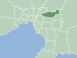
Doncaster East is a suburb of Melbourne, Victoria, Australia, 20 km east of Melbourne's Central Business District, located within the City of Manningham local government area. Doncaster East recorded a population of 30,926 at the 2021 census.

<span class="mw-page-title-main">Templestowe Lower, Victoria</span> Suburb of Melbourne, Victoria, Australia

Templestowe Lower is a suburb of Melbourne, Victoria, Australia, 14 km northeast of Melbourne's Central Business District, located within the City of Manningham local government area. Templestowe Lower recorded a population of 14,098 at the 2021 census.

<span class="mw-page-title-main">Park Orchards, Victoria</span> Suburb of Melbourne, Victoria, Australia

Park Orchards is a suburb of Melbourne, Victoria, Australia, 25 kilometres (16 mi) north-east of Melbourne's Central Business District, located within the Cities of Manningham and Maroondah local government areas. At the 2021 census, Park Orchards recorded a population of 3,835.

<span class="mw-page-title-main">Westerfolds Park</span> Park in Templestowe, Melbourne, Victoria, Australia

Westerfolds Park is a metropolitan park situated in Templestowe, an eastern suburb of Melbourne, Australia.

<span class="mw-page-title-main">Mullum Mullum Creek</span> Creek in Victoria, Australia

Mullum Mullum Creek is a creek in the outer eastern suburbs of Melbourne, Victoria, Australia. It is the main watercourse of the Mullum Mullum Valley, a tributary of the Yarra River and Yarra Valley. For tens of thousands of years it was used as a food and tool source sustainably by the Wurundjeri people, Indigenous Australians of the Kulin nation, who spoke variations of the Woiwurrung language group.

<span class="mw-page-title-main">Jells Park</span>

Jells Park is a public park in Wheelers Hill, a southeastern suburb of Melbourne, Victoria, Australia. The park opened on 30 April 1976 and is named after Joseph Jell, a cattle grazier who worked in the area in the mid-late 1800s. The park attracts in excess of 900,000 visitors a year.

<span class="mw-page-title-main">Mullum Mullum Creek Trail</span>

The Mullum Mullum Creek Trail is a shared use path for cyclists and pedestrians, which follows Mullum Mullum Creek in the outer eastern suburbs in Melbourne, Victoria, Australia.

The Ruffey Creek Trail is a shared use path for cyclists and pedestrians, which follows Ruffey Creek in the inner eastern suburbs of Templestowe and Doncaster in Melbourne, Victoria, Australia.

<span class="mw-page-title-main">City of Doncaster & Templestowe</span> Local government area in Victoria, Australia

The City of Doncaster & Templestowe was a local government area about 20 kilometres (12 mi) east-northeast of Melbourne, the state capital of Victoria, Australia. The city covered an area of 89.42 square kilometres (34.53 sq mi), and existed from 1915 until 1994. At its peak in the early 1990s, it had a population of just over 100,000.

<span class="mw-page-title-main">Main Yarra Trail</span>

The Main Yarra Trail, also known as the Yarra Trail is a shared-use path for cyclists and pedestrians, which follows the Yarra River through the northeastern suburbs of Melbourne, Victoria, Australia.

<span class="mw-page-title-main">Parklands adjoining the Yarra River</span>

The Yarra River is a river in southern Victoria, Australia that flows through the city of Melbourne. There are many parklands, including state parks and national parks, that adjoin the river along its 250 km length. Every park listed has walking tracks, smaller parks usually have unsealed paths, while bigger parks will have sealed pathways suitable for walking and cycling. The Yarra River Trail runs along much of the length of the river's lower reaches through Melbourne. Most parks listed have parking available, the quality and quantity of which varies according to the size of the park. Dogs are not permitted in parklands adjoining the river unless otherwise stated in special off-lead areas.

Petty's Orchard in Templestowe, Victoria, Australia, is among Melbourne’s oldest and last-remaining commercial orchards. A section of the orchard holds one of the largest collection of heritage apple varieties in Australia, including more than 250 varieties of old or rare apples and other types of fruit.

<span class="mw-page-title-main">Koonung Creek Reserve</span>

Koonung Creek Reserve is a linear park in the suburb of Balwyn North, Melbourne, Australia. It follows the path of the Eastern Freeway from Bulleen Road in the west to Doncaster Road to the east.

References

  1. "Ruffey Lake Park". 18 March 2014.
  2. EPA Victoria
  3. Melway Edition 36, 2009