Deep Creek (Melbourne)

Last updated

Deep
Bulla Bridge.JPG
Bridge over the Deep Creek at Bulla, built in 1869.
Maribyrnongrivermap2.png
Contour map of the Maribyrnong River basin; Deep Creek is the eastern tributary that rises on the northern slopes of Mount Macedon.
Location
Country Australia
State Victoria
Region Victorian Midlands (IBRA), Greater Melbourne
Local government area Macedon Ranges Shire, Hume, Brimbank
Physical characteristics
Source Macedon and Cowbaw ranges, Great Dividing Range
  locationnear Cobaw
  coordinates 37°16′30″S144°35′58″E / 37.27500°S 144.59944°E / -37.27500; 144.59944
  elevation517 m (1,696 ft)
Mouth confluence with the Jackson Creek to form the Maribyrnong River
  location
west of Melbourne Airport
  coordinates
37°40′10″S144°48′16″E / 37.66944°S 144.80444°E / -37.66944; 144.80444 Coordinates: 37°40′10″S144°48′16″E / 37.66944°S 144.80444°E / -37.66944; 144.80444
  elevation
42 m (138 ft)
Length128 km (80 mi)
Basin features
River system Port Phillip catchment
Tributaries 
  left Boyd Creek, Dry Creek, Garden Hut Creek, Long Gully Creek
  right Emu Creek, Konagaderra Creek, Monument Creek, Five Mile Creek
[1]

The Deep Creek is a watercourse [2] of the Port Phillip catchment, located in the outer north western suburbs of Melbourne, in the Australian state of Victoria.

Contents

Location and features

Formed by the confluence of a number of smaller streams draining the north eastern slopes of the Macedon Ranges and the southern slopes of the Cobaw range, both ranges being constituent parts of the Great Dividing Range, the Deep Creek rises north of Mount Macedon, near Cobaw. The river flows generally east in a broad shallow valley, to the north of Lancefield, before turning generally southwards towards Penmore to enter the deeper, narrower valley that characterises the remainder of the watercourse. The creek then flows east again before resuming its southward course at Darraweit Guim, towards Bulla, joined by several minor tributaries. The Deep Creek reaches its confluence with the Jackson Creek near Bulla and together they form the Maribyrnong River. [3] The deep and relatively narrow valley cut by the creek in its southward course through the surrounding basalt plains is particularly prominent at such localities as Darraweit Guim, Konagaderra and Bulla. The creek descends approximately 475 metres (1,558 ft) over its 128-kilometre (80 mi) course. [1]

Unregulated by major dams or diversions, the water levels in the creek show great seasonal variation. [4] Recently,[ when? ] Deep Creek flowed only seasonally along most of its length, although significant pools and stretches of water remain all year, some of which are local swimming holes.

Etymology

The creek was originally considered to be the extension of the Maribyrnong River, and as such has also been known as Saltwater River (an original name for the Maribyrnong River) [5] or alternatively the Upper Maribyrnong River, [4] Maribyrnong Creek, [6] Maribyrnong River East Branch [7] or Maribyrnong River Left Branch. Another possible name for the river is Darraweit Guim, [8] also the name of a small town located on the river. The name Deep Creek may refer to the deep valley the watercourse has cut through the plains north of Melbourne or the deep pools which have formed in the riverbed.[ citation needed ]

Geography

The named tributaries of the river, ordered upstream, are:

Crossings

Named bridges and other significant crossing points along Deep Creek, ordered upstream, include but are not limited to:

See also

Related Research Articles

<span class="mw-page-title-main">Yarra River</span> River in Victoria, Australia

The Yarra River or historically, the Yarra Yarra River, is a perennial river in south-central Victoria, Australia.

<span class="mw-page-title-main">Maribyrnong River</span> River in Melbourne, Victoria, Australia

The Maribyrnong River is a perennial river of the Port Phillip catchment, located in the north–western suburbs of Melbourne, in the Australian state of Victoria.

<span class="mw-page-title-main">Bulla, Victoria</span> Town in Victoria, Australia

Bulla is a locality and township in Melbourne, Victoria, Australia, 23 kilometres (14 mi) north-west of Melbourne's Central Business District, located within the City of Hume local government area. Bulla recorded a population of 668 at the 2021 census.

<span class="mw-page-title-main">Tullamarine Freeway</span>

The Tullamarine Freeway, is a major urban freeway in Melbourne, linking Melbourne Airport to the Melbourne City Centre. It carries up to 210,000 vehicles per day and is one of Australia's busiest freeways. The entire stretch of the Tullamarine Freeway bears the designation M2.

<span class="mw-page-title-main">Moonee Ponds Creek</span>

The Moonee Ponds Creek is a creek and major tributary of the Yarra River running through urban Melbourne, Victoria, Australia from northern to inner suburbs. In 2004 a reporter for The Age described it as "arguably the most abused tributary of the Yarra River, and part of the true underside of Melbourne".

<span class="mw-page-title-main">Maribyrnong River Trail</span>

The Maribyrnong River Trail is a shared use path for cyclists and pedestrians, which follows the Maribyrnong River through the north western suburbs of Melbourne, Victoria, Australia.

<span class="mw-page-title-main">Mullum Mullum Creek</span> River in Victoria, Australia

Mullum Mullum Creek is a creek in the outer eastern suburbs of Melbourne, Victoria, Australia. It is the main watercourse of the Mullum Mullum Valley, a tributary of the Yarra River and Yarra Valley. For tens of thousands of years it was used as a food and tool source sustainably by the Wurundjeri people, Indigenous Australians of the Kulin nation, who spoke variations of the Woiwurrung language group.

<span class="mw-page-title-main">Darraweit Guim, Victoria</span> Town in Victoria, Australia

Darraweit Guim is a Victorian locality, situated on Deep Creek, on the edge of the Shire of Macedon Ranges near the shire's boundary with the Shire of Mitchell. In 1992 the town had an approximate population of 300 with approximately 120 homes and a local school overseeing 51 students. Next to the school are the three local tennis courts which are regularly used. Up the hill is the Town Hall, Churches and CFA which protects the area. Platypus can be spotted in the local creek, and wombats also have burrows in the river banks.

<span class="mw-page-title-main">Latrobe River</span> River in Victoria, Australia

The Latrobe River is a perennial river of the West Gippsland catchment, located in the West Gippsland region of the Australian state of Victoria. The Latrobe River and its associated sub-catchment is an important source for the Gippsland Lakes, draining the south eastern slopes of the Great Dividing Range.

<span class="mw-page-title-main">Lancefield, Victoria</span> Town in Victoria, Australia

Lancefield is a town in the Shire of Macedon Ranges local government area in Victoria, Australia 69 kilometres (43 mi) north of the state capital, Melbourne and had a population of 2,743 at the 2021 census.

<span class="mw-page-title-main">Clarkefield, Victoria</span> Town in Victoria, Australia

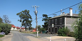
Clarkefield is a town in Victoria, Australia, 41 kilometres (25 mi) north-west of Melbourne's Central Business District, located within the City of Hume and the Shire of Macedon Ranges local government areas. Clarkefield recorded a population of 303 at the 2021 census.

<span class="mw-page-title-main">Dandenong Creek</span> Urban creek in Melbourne, Australia

The Dandenong Creek is an urban creek of the Port Phillip catchment, located in the eastern and south-eastern Greater Melbourne region of the Australian east coast state of Victoria. The creek descends approximately 550 metres (1,800 ft) over its course of 53 kilometres (33 mi) before joining the Eumemmerring Creek to form the Patterson River and eventually draining into the Beaumaris Bay.

<span class="mw-page-title-main">Wildwood, Victoria</span> Town in Victoria, Australia

Wildwood is a bounded locality in Victoria, Australia, 31 km (19 mi) north-west of Melbourne's central business district, located within the City of Hume local government area. Wildwood recorded a population of 244 at the 2021 census.

<span class="mw-page-title-main">Shire of Romsey</span> Local government area in Victoria, Australia

The Shire of Romsey was a local government area about 65 kilometres (40 mi) north-north-west of Melbourne, the state capital of Victoria, Australia. The shire covered an area of 628 square kilometres (242.5 sq mi), and existed from 1862 until 1995.

<span class="mw-page-title-main">Geography of the Yarra River</span>

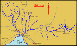
The Yarra River is a river in East-Central Victoria, Australia that flows through the city of Melbourne. This article contains explanations and lists of the river's tributaries and other geographic features. The river flows atop layers of silt that built up within an ancient river valley around 10,000-15,000 years ago.

<span class="mw-page-title-main">Springfield, Victoria (Macedon Ranges)</span> Town in Victoria, Australia

Springfield is a locality in the Shire of Macedon Ranges local government area in central Victoria, Australia approximately 65 kilometres north of the state capital, Melbourne. It is within the catchment area of Deep Creek, a tributary of the Maribyrnong River.

<span class="mw-page-title-main">Buckland River (Victoria)</span> River in Victoria, Australia

The Buckland River, a perennial river of the North-East Murray catchment of the Murray-Darling basin, is located in the alpine region of Victoria, Australia. It flows from the eastern slopes of the Buffalo Range in the Australian Alps, joining with the Ovens River at Porepunkah.

<span class="mw-page-title-main">Organ Pipes National Park</span> Protected area in Victoria, Australia

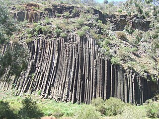
The Organ Pipes National Park, abbreviated as OPNP, is a national park located in the Central region of Victoria, Australia. The 121-hectare (300-acre) protected area was established with the focus on conservation of the native flora and fauna, and preservation of the geological features in the Jacksons Creek, a part of the Maribyrnong valley, north-west of Melbourne. It is situated in a deep gorge in the grassy, basalt Keilor Plains.

<span class="mw-page-title-main">Jackson Creek (Victoria)</span> River in Melbourne, Victoria, Australia

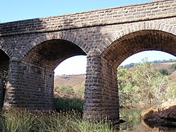
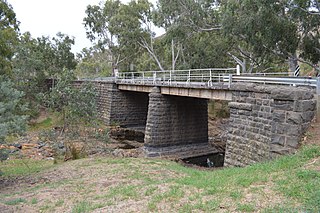
The Jackson Creek is a watercourse of the Port Phillip catchment, located in the outer northern suburbs of Melbourne, in the Australian state of Victoria.

<span class="mw-page-title-main">Geography of Melbourne</span>

Melbourne, the capital city of Victoria, Australia, is situated on the southeastern fringe of the Australian landmass and in the southern central part of the state. Melbourne covers an urbanised area of approximately 2,453 km²–larger than that of Sydney, Greater London and Mexico City, with population density roughly around 16 people per hectare on average.

References

  1. 1 2 "Map of Deep Creek, VIC". Bonzle Digital Atlas of Australia. Retrieved 15 April 2014.
  2. "Deep Creek: 14124". VICNAMES. Government of Victoria. Archived from the original on 16 April 2014. Retrieved 15 April 2014.
  3. "Deep Creek, Lancefield". Fishing Victoria Project. Archived from the original on 17 February 2011. Retrieved 17 June 2010.
  4. 1 2 "Maribyrnong River Basin 30". Department of Primary Industries. Government of Victoria . Retrieved 17 June 2010.
  5. "Maribyrnong River visitors guide" (PDF). Parks Victoria (PDF). Archived from the original (PDF) on 16 March 2011. Retrieved 20 June 2010.
  6. Duncan, J. S., ed. (1982). Atlas of Victoria. Melbourne, Victoria: Victorian Government Printing Office. p. 207. ISBN   0-7241-8255-1.
  7. Victorian Municipal Directory. Brunswick: Arnall & Jackson. 1956. p. 791.
  8. Symonds, Ian William (1985). Bulla Bulla, an illustrated history of the Shire of Bulla. Melbourne: Spectrum. ISBN   978-0-86786-081-8.

Commons-logo.svg Media related to Deep Creek (Victoria) at Wikimedia Commons