
Hume Dam, formerly the Hume Weir, is a major dam across the Murray River downstream of its junction with the Mitta River in the Riverina region of New South Wales, Australia. The dam's purpose includes flood mitigation, hydro-power, irrigation, water supply and conservation. The impounded reservoir is called Lake Hume, formerly the Hume Reservoir. It is a gated concrete gravity dam with four earth embankments and twenty-nine vertical undershot gated concrete overflow spillways.

The Eildon Dam is a rock and earth-fill embankment dam with a controlled spillway across the Goulburn River, is located between the regional towns of Mansfield and Eildon within Lake Eildon National Park, in the Alpine region of Victoria, Australia. The dam's purpose is for the supply of potable water, irrigation, and the generation of hydroelectricity. The impounded reservoir is called Lake Eildon.

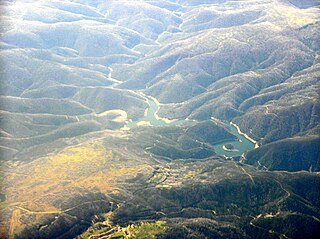
The Loddon River, an inland river of the north–central catchment, part of the Murray-Darling basin, is located in the lower Riverina bioregion and Central Highlands and Loddon Mallee regions of the Australian state of Victoria. The headwaters of the Loddon River rise on the northern slopes of the Great Dividing Range east of Daylesford and descend to flow north into the Little Murray River, near Swan Hill. The river is impounded by the Cairn Curran and Laanecoorie reservoirs. The Tullaroop Creek tributary, which joins just above Laanecoorie Reservoir, is impounded by the Tullaroop Reservoir (72,950ML).

The King River, a perennial river of the North-East Murray catchment of the Murray-Darling basin, is located in the Alpine and Hume regions of Victoria, Australia. It flows from the northwestern slopes of the Alpine National Park in the Australian Alps, through the King Valley, and joining with the Ovens River at the rural city of Wangaratta.
The Tumut Hydroelectric Power Stations is a series of three hydroelectric power stations on the Tumut River in New South Wales, Australia, that are part of the Snowy Mountains Scheme.

The Rubicon Hydroelectric Scheme is a small run-of-the-river hydroelectric scheme located on the Rubicon and Royston Rivers, north east of Melbourne, 40 km (25 mi) south-west of Alexandra, Victoria, Australia. The scheme commenced in 1922, and was the first state-owned hydroelectric scheme to generate electricity in mainland Australia, and among the first in the world to be remotely controlled. For the first ten years of its operation it supplied on average 16.9% of electricity generated by the State Electricity Commission of Victoria. It is now owned and operated by AGL Energy and contributes approximately 0.02% of Victoria's energy supply.
The Catagunya Power Station is a run-of-the-river hydroelectric power station located in the Central Highlands region of Tasmania, Australia. The power station is situated on the Lower River Derwent catchment and is owned and operated by Hydro Tasmania.

The Liapootah Power Station is a run-of-the-river hydroelectric power station located in the Central Highlands region of Tasmania, Australia. The power station is situated on the Lower River Derwent catchment and is owned and operated by Hydro Tasmania.
The Wayatinah Power Station is a run-of-the-river hydroelectric power station located in the Central Highlands region of Tasmania, Australia. The power station is situated on the Lower River Derwent catchment and is owned and operated by Hydro Tasmania.
The Lake Echo Power Station is a conventional hydroelectric power station located in the Central Highlands region of Tasmania, Australia. The power station is situated on the Upper River Derwent catchment and is owned and operated by Hydro Tasmania.
The Fisher Power Station is a conventional hydroelectric power station located in north-western Tasmania, Australia.
The Lemonthyme Power Station is a conventional hydroelectric power station located in north-western Tasmania, Australia. It is the third station in the Mersey–Forth run-of-river scheme that comprises seven conventional hydroelectric power stations and one mini hydro station.

The Trevallyn Power Station is a run-of-the-river hydroelectric power station located in the northern Midlands region of Tasmania, Australia. The power station is situated on the Great Lake and South Esk catchment and is owned and operated by Hydro Tasmania.

Oaky River, a perennial stream of the Macleay River catchment, is located in the Northern Tablelands district of New South Wales, Australia.

Jounama Dam is a major ungated rockfill embankment dam across the Tumut River in the Snowy Mountains of New South Wales, Australia. The dam's main purpose is for the generation of hydro-power and is one of the sixteen major dams that comprise the Snowy Mountains Scheme, a vast hydroelectricity and irrigation complex constructed in south-east Australia between 1949 and 1974 and now run by Snowy Hydro.
Murray Two Dam or Murray 2 Dam is a major ungated concrete arch dam with a controlled spillway across Khancoban Bank, a diverted flow of the Snowy and Geehi rivers in the Snowy Mountains region of New South Wales, Australia. The impounded reservoir is called the Murray Two Pondage or Murray 2 Pondage.
The Tanjil River is a perennial river of the West Gippsland catchment, located in the West Gippsland region of the Australian state of Victoria.
The Meander Dam is a concrete gravity dam across the Upper Meander River, located in northern Tasmania, Australia. The impounded reservoir is called Lake Huntsman.
The Little River, a minor inland perennial river of the Goulburn Broken catchment, part of the Murray-Darling basin, is located in the lower South Eastern Highlands bioregion and Northern Country/North Central regions of the Australian state of Victoria. The headwaters of the Little River rise below the Cathedral Range and descend to flow into the Acheron River at Taggerty.
The Royston River, an inland perennial river of the Goulburn Broken catchment, part of the Murray-Darling basin, is located in the lower South Eastern Highlands bioregion and Northern Country/North Central regions of the Australian state of Victoria. The headwaters of the Royston River rise on the western slopes of the Victorian Alps and descend to flow into the Rubicon River.
