Billabong Creek

Last updated

Billabong
Moulamein [1]
BillabongCreekMoulamein.JPG
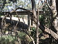
Billabong Creek at Moulamein
Billabong Creek watershed.jpg
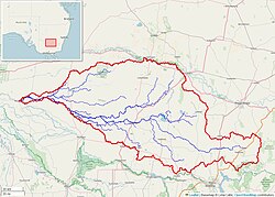
Billabong Creek watershed (Interactive map)
Australia New South Wales relief location map.png
Red pog.svg
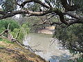
Location of the Billabong Creek mouth in New South Wales
Etymology Aboriginal: an effluent from a river, sometimes separated from it, sometimes being joined again at time of flood. [1] [2]
Location
Country Australia
State New South Wales
Region Riverina (IBRA)
LGA Federation Council
Towns Morven, Culcairn, Walbundrie, Rand, Jerilderie, Conargo, Wanganella, Moulamein
Physical characteristics
Source confluenceYarra Yarra Creek and
Little Billabong Creek
  locationnear Holbrook
  elevation322 m (1,056 ft)
Mouth confluence with the Edward River
  location
Moulamein
  coordinates
35°5′32″S144°2′0″E / 35.09222°S 144.03333°E / -35.09222; 144.03333
  elevation
70 m (230 ft)
Length320 km (200 mi)
Basin size791 km2 (305 sq mi)
Basin features
River system Murray catchment,
Murray-Darling basin
[3] [4]

The Billabong Creek, a partly perennial stream [1] of the Murray River catchment within the Murray-Darling basin, is located in the Riverina region of New South Wales, Australia.

Contents

At 320 kilometres (200 mi) (with some estimates ranging up to 596 kilometres (370 mi) [4] ), Billabong Creek is believed to be the longest creek in the world. [3]

Course and features

Formed by the confluence of the Yarra Yarra Creek and Little Billabong Creek, Billabong Creek rises on the Great Dividing Range, north of Holbrook, and flows generally west, northwest, and west, joined by sixteen minor tributaries before reaching its confluence with the Edward River, at Moulamein. The creek descends 252 metres (827 ft) [4] over its 320-kilometre (200 mi) course.

From source to mouth, the creek passes through the towns of Morven, Culcairn, Walbundrie, Rand, Jerilderie, Conargo, Wanganella, and Moulamein.

The creek has a catchment area of 791 square kilometres (305 sq mi) and is the main present drainage line between the Murray and the Murrumbidgee rivers. [5] Alluvial deposits from the system fill a long narrow paleovalley that extends for about 150 kilometres (93 mi) from Garryowen (near Holbrook) to Walla Walla.

See also

Related Research Articles

The Goobang Creek, a perennial stream of the Lachlan sub–catchment, part of the Murrumbidgee catchment of the Murray-Darling basin, is located in the Central West region of New South Wales, Australia.

The Billabong Creek, a perennial river of the Murrumbidgee catchment within the Murray–Darling basin, is located in the South West Slopes region of New South Wales, Australia.

<span class="mw-page-title-main">Edward River</span> River in New South Wales, Australia.

Edward River, or Kyalite River, an anabranch of the Murray River and part of the Murray–Darling basin, is located in the western Riverina region of south-western New South Wales, Australia.

Jerrabomberra Creek, a partly perennial stream of the Murrumbidgee catchment within the Murray–Darling basin, is located in the Capital Country region spanning both New South Wales and the Australian Capital Territory, Australia.

<span class="mw-page-title-main">Doubtful Creek</span> River in New South Wales, Australia

Doubtful Creek, formerly known as Doubtful River, a watercourse that is part of the Murrumbidgee catchment within the Murray–Darling basin, is located in the Snowy Mountains district of New South Wales, Australia.

Araluen Creek, a partly perennial stream of the Moruya River catchment, is located in the Southern Tablelands and South Coast regions of New South Wales, Australia.

The Jugiong Creek, a mostly–perennial river that is part of the Murrumbidgee catchment within the Murray–Darling basin, is located in the South West Slopes region of New South Wales, Australia.

The Cadiangullong Creek, a mostly–perennial river that is part of the Lachlan sub-catchment of the Murrumbidgee catchment within the Murray–Darling basin, is located in the Central West region of New South Wales, Australia.

The Adjungbilly Creek, a mostly–perennial river that is part of the Murrumbidgee catchment within the Murray–Darling basin, is located in the South West Slopes and Riverina regions of New South Wales, Australia.

The Blakney Creek, a mostly–perennial river that is part of the Lachlan sub-catchment of the Murrumbidgee catchment within the Murray–Darling basin, is located in the South West Slopes region of New South Wales, Australia.

The Burra Creek, a mostly–perennial river that is part of the Murrumbidgee catchment within the Murray–Darling basin, is located in the Monaro and Southern Tablelands regions of New South Wales, Australia.

The Cooma Back Creek, a mostly–perennial river that is part of the Murrumbidgee catchment within the Murray–Darling basin, is located in the Monaro region of New South Wales, Australia.

The Cullinga Creek, a mostly–perennial river that is part of the Murrumbidgee catchment within the Murray–Darling basin, is located in the South West Slopes region of New South Wales, Australia.

The Derringullen Creek, a mostly–perennial river that is part of the Murrumbidgee catchment within the Murray–Darling basin, located in the South West Slopes region of New South Wales, Australia.

The Gunningbland Creek, a perennial river of the Lachlan sub–catchment, part of the Murrumbidgee catchment of the Murray-Darling basin, is located in the Central West region of New South Wales, Australia.

The Jeir Creek, a perennial river that is part of the Murrumbidgee catchment within the Murray–Darling basin, is located in the South West Slopes region of New South Wales, Australia.

The Jerra Jerra Creek, a perennial stream of the Murray River catchment within the Murray-Darling basin, is located in the Riverina region of New South Wales, Australia.

<span class="mw-page-title-main">Mirrool Creek</span> River in New South Wales, Australia

Mirrool Creek, a watercourse that is part of the Lachlan sub-catchment of the Murrumbidgee catchment in the Murray–Darling basin, is in the Riverina region of New South Wales, Australia. The course of the Mirrool Creek is indefinite at various locations.

<span class="mw-page-title-main">Pudman Creek</span> River in New South Wales, Australia

The Pudman Creek, a perennial stream that is part of the Lachlan sub-catchment of the Murrumbidgee catchment within the Murray–Darling basin, is located in the South West Slopes region of New South Wales, Australia.

The Rocky Ponds Creek, a watercourse that is part of the Murrumbidgee catchment within the Murray–Darling basin, is located in the South West Slopes region of New South Wales, Australia.

References

  1. 1 2 3 "Billabong Creek". Geographical Names Register (GNR) of NSW. Geographical Names Board of New South Wales . Retrieved 16 June 2013. OOjs UI icon edit-ltr-progressive.svg
  2. Reed, A. W. (1973). Place names of Australia. Frenchs Forest, New South Wales: Reed Books. p. 31. ISBN   0-589-50128-3.
  3. 1 2 "Billabong Creek Salt Interception Scheme". NSW Department of Primary Industries: Office of Water. 2009. Retrieved 16 June 2013.
  4. 1 2 3 "Map of Billabong Creek, NSW". Bonzle Digital Atlas of Australia. Retrieved 16 June 2013.
  5. "Water Resources Overview – New South Wales". ANRA. Government of Australia. 2009. Archived from the original on 21 March 2011. Retrieved 16 October 2010.