The South Island, also officially named Te Waipounamu, is the larger of the two major islands of New Zealand in surface area; the other being the smaller but more populous North Island. It is bordered to the north by Cook Strait, to the west by the Tasman Sea, and to the south and east by the Pacific Ocean. The South Island covers 150,437 square kilometres (58,084 sq mi), making it the world's 12th-largest island. It has a temperate climate.

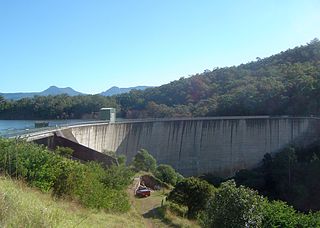
Hume Dam, formerly the Hume Weir, is a major dam across the Murray River downstream of its junction with the Mitta River in the Riverina region of New South Wales, Australia. The dam's purpose includes flood mitigation, hydro-power, irrigation, water supply and conservation. The impounded reservoir is called Lake Hume, formerly the Hume Reservoir. It is a gated concrete gravity dam with four earth embankments and twenty-nine vertical undershot gated concrete overflow spillways.

Chemong Lake, or Lake Chemong, " is a lake 8 kilometres (5.0 mi) northwest of Peterborough, Ontario, Canada, near the town of Bridgenorth. The lake extends from near Fowlers Corners north to near Curve Lake. Lake Chemong has a length of 14 kilometres (8.7 mi) and a width of 1 kilometre (0.62 mi).

Lake Superior Provincial Park is one of the largest provincial parks in Ontario, covering about 1,550 square kilometres (600 sq mi) along the northeastern shores of Lake Superior between Sault Ste. Marie in Algoma District, and Wawa in Northeastern Ontario, Canada. Ontario Highway 17 now runs through the park. When the park was established by Ontario in 1944, there was no road access.
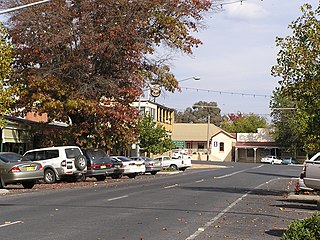
Tumbarumba is a small town in New South Wales, Australia, about 480 kilometres (300 mi) southwest of the state capital, Sydney. Tumbarumba is located on the periphery of the Riverina and South West Slopes regions at the western edge of the Snowy Mountains. The 2016 census showed the population of the town and surrounding area to be 1,862 people. Locals refer to the town as 'Tumba'.

Pulicat Lagoon is the second largest brackish water lagoon in India, after Chilika Lake. Pulicat Lagoon is considered to be the second largest brackish water body in India measuring 759* km2. The Lagoon is one of the three important wetlands to attract North-East Monsoon rain clouds during October to December season to Tamil Nadu. The lagoon comprises the following regions, which adds up 759 km2 according to Andhra Pradesh Forest Department*: 1) Pulicat Lake 2) Marshy/Wetland Land Region (AP) 3) Venadu Reserve Forest (AP) 4) Pernadu Reserve Forest (AP) The lagoon was cut across in the middle the Sriharikota Link Road, which divided the water body into lake and marshy land. The lake encompasses the Pulicat Lake Bird Sanctuary. The barrier island of Sriharikota separates the lake from the Bay of Bengal and is home to the Satish Dhawan Space Centre. Major part of the lake comes under Nellore district of Andhra pradesh.

Mbarara District is a district in South Western Uganda. The district was named after its chief municipal centre, the city of Mbarara, where the district headquarters are located.

San Francisco, officially the Municipality of San Francisco,, is a 3rd class municipality in the province of Cebu, Philippines. According to the 2015 census, it has a population of 55,180 people.

Glenrock Lagoon, an intermediate freshwater small coastal creek, is located within the Lake Macquarie local government area in the Newcastle and Hunter regions of New South Wales, Australia. The lake is located near the Newcastle suburbs of Adamstown and Dudley and is situated about 153 kilometres (95 mi) north of Sydney.
Hell's Gate National Park lies south of Lake Naivasha in Kenya, north west of Nairobi. Hell's Gate National Park is named after a narrow break in the cliffs, once a tributary of a prehistoric lake that fed early humans in the Rift Valley. It was established in 1984. A small national park, it is known for its wide variety of wildlife and for its scenery. This includes the Fischer's Tower and Central Tower columns and Hell's Gate Gorge. The national park is also home to three geothermal power stations at Olkaria. The park is equipped with three basic campsites and includes a Maasai Cultural Center, providing education about the Maasai tribe's culture and traditions.

The Wivenhoe Dam is a rock and earth-fill embankment dam with a concrete spillway across the Brisbane River in South East Queensland, Australia. The dam wall is located about 80 kilometres (50 mi) by road from the centre of Brisbane. The primary purpose of the dam is the supply of potable water for the Brisbane and Ipswich regions. In addition, the dam also provides for flood mitigation control, hydroelectricity and for recreation. The impounded reservoir is called Lake Wivenhoe and the dam, the lake and a narrow strip of surrounding land forms a locality also called Lake Wivenhoe.
The Moogerah Dam is a mass concrete double curvature arch dam with a un-gated spillway across the Reynolds Creek that is located in the South East region of Queensland, Australia. The main purposes of the dam are for irrigation of the Reynolds Creek and for supply of potable water to Warrill Creek and farmers in the Warrill Valley. The impounded reservoir is called Lake Moogerah.

Lake Macquarie or Awaba is Australia's largest coastal salt water lagoon. Located in the Hunter Region of New South Wales, it covers an area of 110 square kilometres (42.5 sq mi) and is connected to the Tasman Sea by a short channel. Most of the residents of the City of Lake Macquarie live near the shores of the lake.

Ournie is a rural community in the far south east part of the Riverina and situated about 15 kilometres north west from Welaregang and 20 kilometres south from Munderoo. Ournie is situated on the banks of the Ournie Creek which flows into the Murray River and the area is only about 4 kilometres from the border of Victoria.

Book Book is a rural community in the central east part of the Riverina. It is situated about 12 km (7 mi) north of Kyeamba and 15 km (9 mi) south of Ladysmith.

Rocky Creek Dam is a minor rock fill clay core embankment dam across the Rocky Creek, located upstream of Lismore in the Northern Rivers region of New South Wales, Australia. The dam's main purpose is to supply potable water for the region, including Lismore, Ballina, Byron Bay, Evans Head and Alstonville. The impounded reservoir is called Rocky Lake.

The Langwieder lake district is composed of three lakes west of Munich in Bavaria, Germany. It opened in the year 2000 as a recreational area enclosing the Langwieder See, the Lußsee, and the Birkensee. The entire site spans 120 hectares ; 40 of which are the lakes and 80 are land; 27 hectares of which are lawns for sunbathing.

Rydal Dam is a minor ungated homogeneous earthfill embankment dam with a fuse plug uncontrolled open channel spillway across an off stream storage, located near Rydal in the Central Tablelands region of New South Wales, Australia. The dam's purpose is to provide water storage for Delta power stations at Wallerawang and Mount Piper. The impounded reservoir is also called the Rydal Dam.