The Shoalhaven River is a perennial river that rises from the Southern Tablelands and flows into an open mature wave dominated barrier estuary near Nowra on the South Coast of New South Wales, Australia.
Spencers Brook is a waterway, locality and a district located within the Avon Valley in Western Australia.

Tumut is a town in the Riverina region of New South Wales, Australia, situated on the banks of the Tumut River.

Morgan is a town in South Australia on the right bank of the Murray River, just downstream of where it turns from flowing roughly westwards to roughly southwards. It is about 161 kilometres (100 mi) north east of Adelaide, and about 315 kilometres (196 mi) upstream of the Murray Mouth. At the 2006 census, Morgan had a population of 426.

Mongarlowe is a village in the Southern Tablelands of New South Wales, Australia in Queanbeyan-Palerang Regional Council. In former times, it was also known, in various contexts, as Little River, Monga, and Sergeants Point.

Mount Stromlo is a mountain with an elevation of 770 metres (2,530 ft) AHD that is situated in the Australian Capital Territory, Australia. The mountain is most notable as the location of the Mount Stromlo Observatory. The mountain forms part of the catchment area of the Cotter River which in turn is the primary water supply for part of ACT.

Canberra railway station is located on the NSW TrainLink Regional Southern Line in the Australian Capital Territory, Australia. It is located in the Canberra suburb of Kingston.

The Coomera River is a perennial river located in the South East region of Queensland, Australia. Its catchment lies within the Gold Coast and Scenic Rim Region local government areas and covers an area of 489 square kilometres (189 sq mi).

Tooma is a village community in the eastern part of the Riverina and situated about 11 kilometres (6.8 mi) east of Welaregang and 34 kilometres (21 mi) south of Tumbarumba.

Milang is a town and locality located in the Australian state of South Australia on the west coast of Lake Alexandrina about 71 kilometres (44 mi) south-east of the state capital of Adelaide and about 20 kilometres (12 mi) north-east of the municipal seat of Goolwa.

Forrest Highway is a 95-kilometre-long (59 mi) highway in Western Australia's Peel and South West regions, extending Perth's Kwinana Freeway from east of Mandurah down to Bunbury. Old Coast Road was the original Mandurah–Bunbury route, dating back to the 1840s. Part of that road, and the Australind Bypass around Australind and Eaton, were subsumed by Forrest Highway. The highway begins at Kwinana Freeway's southern terminus in Ravenswood, continues around the Peel Inlet to Lake Clifton, and heads south to finish at Bunbury's Eelup Roundabout. There are a number of at-grade intersections with minor roads in the shires of Murray, Waroona, and Harvey including Greenlands Road and Old Bunbury Road, both of which connect to South Western Highway near Pinjarra.

Port Kembla is a man-made cargo port or artificial harbour, with an outer harbour protected by breakwaters and an inner harbour constructed by dredging, located in the Illawarra region of New South Wales, Australia.
Rock Flat Creek is a watercourse that is part of the Murrumbidgee catchment within the Murray–Darling basin. It is located in the Monaro region of New South Wales, Australia.

The Snowy Valleys Council is a local government area located in the South West Slopes region of New South Wales, Australia. This area was formed in 2016 from the merger of the Tumut Shire with the neighbouring Tumbarumba Shire.

Jerrawa is a locality in the Upper Lachlan Shire, New South Wales, Australia. It lies on the north side of the Hume Highway about 30 km to the east of Yass and was served by Jerrawa railway station on the Main Southern line between Sydney and Melbourne between 1876 and 1975. At the 2016 census, it had a population of 73.

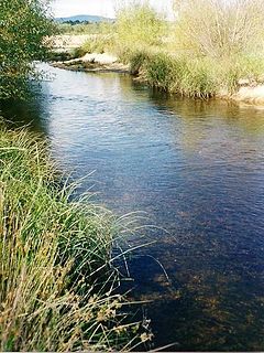
Larbert is a locality in the Queanbeyan-Palerang Region of the Southern Tablelands region of New South Wales. It lies mostly north of the Kings Highway between Bungendore and Braidwood where it crosses the Shoalhaven River. At the 2016 census, it had a population of 39.

Monga is a locality in the Queanbeyan-Palerang Region, Southern Tablelands, New South Wales, Australia. It lies on the Kings Highway at the top of the Clyde Mountain, about 110 km east of Canberra and 22 km southeast of Braidwood. A large part of the locality forms part of the Monga National Park. At the 2016 census, it had a population of 14.
Gadara Shire was a local government area in the eastern part of the Riverina region of New South Wales, Australia.

Currowan is a locality in the Eurobodalla Shire, on the South Coast of New South Wales, Australia. At the 2016 census, it had a population of 53.
Little River is a rural locality in the Snowy Valleys Council local government area of New South Wales, Australia. It lies is 6 km east of Tumut, in the southern side of the valley of the Goobarragandra River, just to the east of the confluence of that river with the Tumut River. The Goobarragandra River was once also known as 'Tumut Little River' or just as 'Little River', giving rise to the locality's name. At the 2016 census, it had a population of 47.


