
The Wollondilly River, an Australian perennial river that is part of the Hawkesbury–Nepean catchment, is located in the Southern Tablelands and Southern Highlands regions of New South Wales. The river meanders from its western slopes near Crookwell, flowing south-east through Goulburn, turning north-east to near Bullio, flowing north-west to Barrallier, before finally heading north-easterly into its mouth at Lake Burragorang.

The Numeralla River, a perennial river that is part of the Murrumbidgee catchment within the Murray–Darling basin, is located in the Monaro region of New South Wales, Australia.
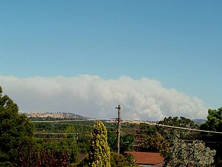
The Pulletop bushfire, officially referred to as the Wandoo fire, started on the 6 February 2006 in hot dry and windy weather conditions approximately 30 kilometres (19 mi) southeast of Wagga Wagga in the Australian state of New South Wales. The fire was thought to have been started by sparks from a tractor on a property at Pulletop which quickly got out of control. The New South Wales Rural Fire Service declared a bushfire emergency and the Hume Highway was closed late in the afternoon with fears that the fire would threaten the towns of Humula, Book Book, Livingstone and Kyeamba after 10 square kilometres (3.9 sq mi) of farmland was burnt. By 7 February 2006 milder conditions helped firefighters to control the fire burning in inaccessible country.

Bowna is a locality in the South East part of the Riverina, New South Wales, Australia.
Woodend is a rural community in the central part of the Riverina about 14 kilometres north east of Pleasant Hills. It is situated by road, about 12 kilometres west from Yerong Creek and 23 kilometres east from Osborne.
Walleroobie is a locality in the north-east part of the Riverina region of south-west New South Wales, Australia. It is situated, by road, about 15 kilometres (9.3 mi) north-east of Cowabbie and 19 kilometres (12 mi) south-east of Ardlethan.
Brookdale is a rural locality in the central east part of the Riverina. It is about 8 kilometres, by road, north-west of Bullenbung and 34 kilometres south-east of Galore.

Burrandana is a rural locality in the south eastern part of the Riverina. It is situated by road, about five kilometres (3.1 mi) east south-east of Pulletop and nine kilometres (5.6 mi) north of Mangoplah.
The Bemboka River, a perennial stream of the Bega River catchment, is located in the Monaro and South Coast regions of New South Wales, Australia.
The Bendoc River is a perennial river of the Snowy River catchment, located in the Alpine regions of the states of Victoria and New South Wales, Australia.
The Boomi River, an anabranch of the Barwon River and part of the Macintyre catchment within the Murray–Darling basin, is located in the north–western slopes region of New South Wales, flowing downstream into the South Downs region of Queensland, Australia.

Boorowa River, a perennial stream that is part of the Lachlan catchment within the Murray–Darling basin, is located in the central–western region of New South Wales, Australia.
The Delegate River is a perennial river of the Snowy River catchment, located in the Alpine regions of the states of Victoria and New South Wales, Australia.

The Wallagaraugh River is a perennial river of the Genoa River catchment, with its headwaters located in the South Coast region of New South Wales and its lower reaches located in the East Gippsland region of Victoria, Australia.
The Queensborough River is a perennial river of the Snowy River catchment, located in the Alpine regions of the Australian states of Victoria and New South Wales.
The Sandy Creek, a perennial stream of the Richmond River catchment, is located in Northern Rivers region in the state of New South Wales, Australia.
The Shannon Brook, a perennial stream of the Richmond River catchment, is located in Northern Rivers region in the state of New South Wales, Australia.
The Clouds Creek, a perennial stream that is part of the Clarence River catchment, is located in the Northern Tablelands region of New South Wales, Australia.
Connollys Creek, a watercourse of the Manning River catchment, is located in the Mid North Coast region of New South Wales, Australia.
The River Pocwock is a tributary of the Saint John River, flowing in:

