Oxley, New South Wales

Last updated

Oxley
New South Wales
Oxley NSW Town Entry Sign.JPG
Entry sign
Australia New South Wales location map blank.svg
Red pog.svg
Oxley
Coordinates 34°10′S144°06′E / 34.167°S 144.100°E / -34.167; 144.100
Population159 (2006 census) [1]
Postcode(s) 2711
LGA(s) Balranald Shire
County Waljeers
State electorate(s) Murray
Federal division(s) Farrer

Oxley is a community on the lower Lachlan River in the Riverina district of New South Wales, Australia near the junction of the Lachlan and Murrumbidgee Rivers. The township which developed in the mid-1860s was named after the noted Australian explorer, John Oxley. At the 2006 census, Oxley had a population of 159 people. [1]

Contents

History

The Lachlan River at Oxley. Oxley Lachlan River 002.JPG
The Lachlan River at Oxley.

Aboriginal History

Oxley is part of the traditional lands of the Muthi Muthi Aboriginal tribe. In 1836 explorer Major Mitchell took Muthi Muthi woman Tourandury and her 4-year-old daughter Ballandella from Oxley as guides through the land. Tourandury was also part of a group of Aborigines who met with explorer Charles Sturt and helped him when his whale boat capsized on the nearby Murrumbidgee river. Ballandella was removed from her mother and taken to Sydney to be educated by Mitchell and his friend Dr Nicholson. Queen Caroline of Oxley and her sister Judy are apical ancestors of many surviving Muthi Muthi people today.

"Oxley" and "Tupra" stations

In about the mid-1840s Phelps and Chadwick took up a run on the lower Lachlan which they called "Thelangerin West".  In 1848 the lease was purchased by Thomas D'Archy who renamed the run "Oxley", and called the station homestead "Oxley House". [2]

Opposite the "Oxley" run on the north bank of the Lachlan River was the "Tupra" run, held by the Tyson brothers since the 1840s.  By the 1860s it was held solely by James Tyson.

Oxley township

In the mid-1860s the squatter James Tyson saw a business opportunity and built a hotel at a new township which was developing at a crossing-place over the river on his "Tupra" run.  A report in the Pastoral Times newspaper in November 1866 stated that "Mr. Tyson has built a brick hotel" which was to be opened shortly at the "new township of Oxley".  The report added: "There is not much traffic past the house, and very few men in the neighborhood, so the prospects of doing a good trade are not very encouraging". [3]

Bridge over the Lachlan River Oxley Lachlan River Bridge.JPG
Bridge over the Lachlan River

In December 1866 it was reported that a petition was to be sent to Government "to place a sum of money on the estimates to build a bridge at a point of the Lachlan River, about eight miles above the government township of Oxley, which is opposite Mr. D'Archy's station".  The report added that "there is a boat there at present, which is a great convenience to persons travelling". [4]

A Government land-sale, which included lots at Oxley township, was held at Hay on 9 March 1868. [5]

Tyson's brick hotel was called the Oxley Hotel; during 1869 Thomas Donahee was recorded as the licensee.  In April 1870 at the Hay Police Court Daniel Murphy, "formerly of Maude", applied for a licence for the Oxley Hotel (which was subsequently granted).  In December 1870 George Carter was successful in his application for a licence for a second public-house at Oxley, called the Stockman's Hotel. [6]

George Carter remained publican of the Stockman's Hotel at Oxley until 1872 when he apparently closed his establishment to carry on the nearby Paika Creek Hotel at Paika Creek.  The Oxley Hotel was once again the sole public-house at the township; Daniel Murphy remained publican until 1874. [7]

In June 1874 the publican's licence for the Oxley Hotel was transferred from Daniel Murphy to John Murphy.  The ownership of the Oxley Hotel apparently remained in the hands of James Tyson (with the various publicans leasing the hotel).  In January 1875 advertisements were placed in the Riverine Grazier newspaper by Tyson's nephew, James Tyson Jnr., seeking a "respectable tenant" for the Oxley Hotel.  A month later it was reported that John Murphy's licence for the Oxley Hotel was to be transferred to Mr. Robert Jackson.  Jackson was the publican of the Oxley Hotel during 1875 to 1877. [8]

In 1878 Michael Joseph Delandre took over the licence.  Delandre had previously been a policeman, stationed at Maude.  A traveller to Oxley in early 1879 reported that "Mr. Delandre… runs a hotel business with a little storekeeping combined".  The Oxley Hotel was described as "one of the most comfortable and cleanly roadside houses I have met with; the building is substantial and commodious".  The writer reported that Delandre "with an eye to business, is constructing a pontoon bridge, which he intends laying across the river in front of his house".  He added: "In his undertaking [Delandre] deserves support and success, for the bridge will be a great boon to travelling stock, and also to the passengers from Hay to Balranald, as Messrs. Cobb and Co. will run coaches between those towns as soon as the bridge is completed, whereas at present the mails are carried on horseback". [9]

St Barnabas Anglican Church, Oxley Oxley NSW Anglican Church 003.JPG
St Barnabas Anglican Church, Oxley

Just two years later another traveller who arrived at Oxley on the mail-coach described Delandre's pontoon-bridge as "a wretched apology for a bridge, in the shape of a pontoon, the condition of which seems to be verging upon the last stages of dissolution". [10]

In 1881 Oxley township once again had two hotels when the Royal Hotel was opened with John Westhead as the publican.  In 1882 there was a re-shuffle of publicans as Delandre left the Oxley Hotel to be replaced by William Westhead, and Daniel Murphy took over the licence of the Royal. [7]

Oxley Post Office opened on 1 November 1884 and closed in 1969. [11]

In about 1888 the Royal Hotel had ceased trading at Oxley.  In 1889 a licence was granted to Thompson S. Page for a new public-house at the township, the Commercial Hotel (possibly a name-change of the old Royal Hotel premises).  In 1889 the publican of the Oxley Hotel was John Parr. [7]

In 1890 "Oxley" station was purchased by the A.M.L.&F. Company.  R. P. McFarland purchased "Oxley" station in 1912. [12]

Related Research Articles

<span class="mw-page-title-main">Balranald</span> Town in New South Wales, Australia

Balranald is a town within the local government area of Balranald Shire, in the Murray region of New South Wales, Australia.

<span class="mw-page-title-main">Hay, New South Wales</span> Town in New South Wales, Australia

Hay is a town in the western Riverina region of south western New South Wales, Australia. It is the administrative centre of Hay Shire local government area and the centre of a prosperous and productive agricultural district on the wide Hay Plains.

<span class="mw-page-title-main">Hillston, New South Wales</span> Town in New South Wales, Australia

Hillston is a township in western New South Wales, Australia, in Carrathool Shire, on the banks of the Lachlan River. It was founded in 1863 and at the 2024 census had a population of 1,544.

<span class="mw-page-title-main">Conargo</span> Town in New South Wales, Australia

Conargo is a town in the Riverina region of New South Wales, Australia. The town is in the Edward River Council local government area. It is on Billabong Creek, a tributary of the Edward River. The nearest towns are Jerilderie and Deniliquin. At the 2006 census, Conargo had a population of 117 people.

<span class="mw-page-title-main">Ivanhoe, New South Wales</span> Town in New South Wales, Australia

Ivanhoe is a very small township on the Cobb Highway between the Lachlan and Darling rivers in New South Wales, Australia. It is located within the Central Darling Shire local government area. Ivanhoe functions as a service centre for the surrounding area. The township is characterised by a particularly wide main street. At the 2016 census, Ivanhoe had a population of 196 people.

<span class="mw-page-title-main">Darlington Point</span> Town in New South Wales, Australia

Darlington Point is a small town on the banks of the Murrumbidgee River in the Riverina district of western New South Wales, Australia. It is part of the Murrumbidgee Council local government area. The centre of town is four kilometres from the Sturt Highway, along Kidman Way. Darlington Point is 631 kilometres (392 mi) south-west of Sydney and 33 kilometres (21 mi) south of Griffith. At the 2021 census, Darlington Point had a population of 1,030.

<span class="mw-page-title-main">James Tyson</span> Australian politician

James Tyson was an Australian pastoralist. He is regarded as Australia's first self-made millionaire. His name became a byword for reticence, wealth and astute dealing.

<span class="mw-page-title-main">Mount Hope, New South Wales</span> Town in New South Wales, Australia

Mount Hope is a settlement in western New South Wales, Australia. It is situated on the Kidman Way, 95 kilometres north of Hillston and 160 km south of Cobar. A government township called 'Nombinnie' was surveyed in the mid-1880s but that name was rarely used.

<span class="mw-page-title-main">Gunbar, New South Wales</span> Town in New South Wales, Australia

Gunbar is in the Riverina district of south-western New South Wales in Australia, on a wide bend of the Mid-Western Highway between Goolgowi and Hay. It is part of the Carrathool Shire local government area, administered from Goolgowi. At the 2006 census, Gunbar had a population of 97 people.

<span class="mw-page-title-main">Rankins Springs</span> Suburb of Carrathool Shire, New South Wales, Australia

Rankins Springs is a village in the Riverina region of New South Wales, Australia in Carrathool Shire and on the Mid-Western Highway. At the 2011 census, Rankins Springs had a population of 299 residents living in 145 private dwellings. This dropped to 174 in 2016, but rebounded to 208 in 2021. The settlement is strung out along the Mid-Western Highway and adjacent railway line. The main agricultural activities of the district around Rankins Springs are the growing of crops such as wheat and oats, and beef-cattle.

<span class="mw-page-title-main">Booligal</span> Town in New South Wales, Australia

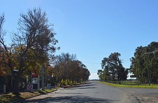
Booligal is a village in the Riverina area of western New South Wales (NSW), Australia. It is located on the Cobb Highway, on the Lachlan River north of Hay. Booligal is a part of Hay Shire local government area.

<span class="mw-page-title-main">Maude, New South Wales</span> Town in New South Wales, Australia

Maude is a village on the north bank of the Murrumbidgee River in New South Wales, Australia. It is in between Hay and Balranald in Hay Shire. It is 55 kilometres downstream from Hay and 25 kilometres upstream from the junction of the Lachlan River with the Murrumbidgee. At the 2006 census, it had a population of 161. It consists of a general store, hotel, post office and caravan park. It is surrounded by market gardens supplied with water from Maude Weir, a popular spot for anglers looking for yellow belly, redfin and Murray cod.

<span class="mw-page-title-main">Kyalite</span> Town in New South Wales, Australia

Kyalite is a locality on the Wakool River in the Riverina district of the Australian state of New South Wales. It is part of Balranald Shire and is approximately 890 kilometres (550 mi) south west of the state capital Sydney and 400 kilometres (250 mi) north west of Melbourne. Kyalite was formerly known as Wakool Crossing. At the 2021 census, Kyalite had a population of 87.

<span class="mw-page-title-main">Penarie, New South Wales</span> Town in New South Wales, Australia

Penarie is a small settlement about 32 kilometres north of Balranald, in the Riverina district of New South Wales, Australia. It is part of Balranald Shire. Penarie is situated at a junction on the road between Balranald and Ivanhoe, where a branch road leads to Oxley. Penarie was formerly known as Homebush.

<span class="mw-page-title-main">Booroorban</span> Town in New South Wales, Australia

Booroorban is a locality in the central part of the Riverina. It is in the Edward River Council local government area and on the Cobb Highway between Hay and Deniliquin, around 769 kilometres (478 mi) south west of the state capital, Sydney. At the 2016 census, Booroorban had a population of 33.

Mossgiel is a location in New South Wales, Australia, in Carrathool Shire. It was a township on the coach route between the Lachlan and Darling Rivers, 50 km southeast of Ivanhoe near the junction with the road to Hillston. The settlement experienced a steady decline during the 20th century. Nowadays Mossgiel township consists of one house and a community hall.

<span class="mw-page-title-main">One Tree, New South Wales</span> Town in New South Wales, Australia

One Tree is a location on the Cobb Highway on the flat plain between Hay and Booligal in the Riverina district of New South Wales, Australia. In 1862 a public house was built there, originally called Finch's Inn and the locality developed as a coach changing-stage and watering-place between the Murrumbidgee and Lachlan rivers. One Tree village was surveyed and proclaimed in 1882, though the location remained as just an amenity on the plain, centred on the hotel.

<span class="mw-page-title-main">Muthi Muthi</span>

The Muthi Muthi people are an indigenous Australian people whose traditional lands are located in the Northern Riverina and Far West regions of New South Wales.

The Hay Standard was an English language newspaper published in Hay, New South Wales, from 1871 to 1900. It was the first newspaper published at Hay.

<span class="mw-page-title-main">Hay Bridge, New South Wales</span> Bridge in New South Wales, Australia

The Hay Bridge is a road bridge that carries the Cobb Highway across the Murrumbidgee River at Hay, New South Wales, Australia. The current bridge is the second bridge located in Hay that crosses the Murrumbidgee; the first bridge was in operation from 1873 until 1973; the second and current bridge has operated since 1973.

References

  1. 1 2 Australian Bureau of Statistics (25 October 2007). "Oxley (Balranald) (State Suburb)". 2006 Census QuickStats. Retrieved 10 November 2009.
  2. Feldtmann, Arthur, The Balranald Story, 1976 (a souvenir of the 'Back to Balranald' celebration - 28 September to 5 October 1976).
  3. Pastoral Times, 17 November 1866, p. 3.
  4. Pastoral Times, 1 December 1866, p. 3.
  5. New South Wales Government Gazette, No. 35, Friday, 7 February 1868, p. 372-3.
  6. Hotel Publicans Licences, NSW Government Gazettes; Pastoral Times, 23 April 1870, p. 2; 3 December 1870, p. 2.
  7. 1 2 3 Hotel Publicans Licences, NSW Government Gazettes.
  8. Riverine Grazier, 6 January 1875, p. 3 (and subsequent issues); Riverine Grazier, 17 February 1875, p. 2.
  9. ’A Tale of Many Towns’, by ‘the Waif’, Town and Country Journal, 15 February 1879, p. 306.
  10. ’Hay to Balranald’, by ‘the Raven’, Town and Country Journal, 21 May 1881, p. 992.
  11. Premier Postal History, Post Office List , retrieved 11 June 2009
  12. Feldtmann, op. cit.

Commons-logo.svg Media related to Oxley, New South Wales at Wikimedia Commons