Murrumbidgee Council

Last updated

Murrumbidgee Council
New South Wales
Murrumbidgee Council LGA NSW.png
Location in New South Wales
Coordinates 35°9′S145°46′E / 35.150°S 145.767°E / -35.150; 145.767
Population
 • Density0.5561/km2 (1.4403/sq mi)
Established12 May 2016 (2016-05-12)
Area6,880 km2 (2,656.4 sq mi) [3]
MayorRuth McRae
Region Riverina
State electorate(s) Murray
Federal division(s) Farrer
Murrumbidgee Council Logo.png
Website Murrumbidgee Council
LGAs around Murrumbidgee Council:
Carrathool Carrathool, Griffith Leeton
Hay, Edward River Murrumbidgee Council Narrandera, Federation
Edward River Berrigan Federation

Murrumbidgee Council is a local government area in the Riverina region of New South Wales, Australia. This area was formed in 2016 from the merger of the Murrumbidgee Shire and the Jerilderie Shire. [3]

Contents

The combined area comprises 6,880 square kilometres (2,660 sq mi) and covers the urban areas of Coleambally, Darlington Point and Jerilderie and the surrounding cropping and pastoral areas. At the time of its establishment, the estimated population of the area was 4,047. [3]

The inaugural mayor of Murrumbidgee Council is former Jerilderie Shire councillor Ruth McRae, elected on 21 September 2017. [4] Cr McRae was elected as mayor for the second term on 24 September 2019. [5]

Demographics

Selected historical census data for Murrumbidgee Council local government area
Census year2001 [6] 2006 [7] 2011 [8] 2016 [1]
PopulationEstimated residents on census night 2,502Increase2.svg 2,503Decrease2.svg 2,261Increase2.svg 3,836
LGA rank in terms of size within New South Wales 117thSteady2.svg 117th
% of New South Wales population0.04%Steady2.svg 0.04%Decrease2.svg 0.03%Increase2.svg 0.05%
% of Australian population0.01%Steady2.svg 0.01%Steady2.svg 0.01%Increase2.svg 0.02%
Cultural and language diversity
Ancestry,
top responses
Australian 36.4%Decrease2.svg 35.0%
English 27.4%Increase2.svg 27.6%
Irish 9.6%Decrease2.svg 9.3%
Scottish 7.7%Increase2.svg 7.8%
Italian n/cIncrease2.svg 3.2%
Language,
top responses
(other than English)
Italian 0.3%Increase2.svg 0.4%Increase2.svg 0.5%Decrease2.svg 0.4%
Spanish n/cSteady2.svg n/cSteady2.svg n/cIncrease2.svg 0.3%
Arabic n/cSteady2.svg n/cSteady2.svg n/cIncrease2.svg 0.3%
Tagalog 0.2%Decrease2.svg n/cIncrease2.svg 0.5%Decrease2.svg 0.3%
Mandarin n/cSteady2.svg n/cSteady2.svg n/cIncrease2.svg 0.3%
Religious affiliation
Religious affiliation,
top responses
Catholic 28.9%Decrease2.svg 28.0%Increase2.svg 28.3%Increase2.svg 28.9%
Anglican 33.0%Decrease2.svg 32.8%Decrease2.svg 29.9%Decrease2.svg 22.3%
No Religion, so described9.2%Decrease2.svg 8.7%Increase2.svg 13.6%Increase2.svg 18.7%
Not statedn/cSteady2.svg n/cSteady2.svg n/cIncrease2.svg 12.1%
Uniting Church 11.2%Decrease2.svg 9.8%Decrease2.svg 8.2%Increase2.svg 8.5%
Median weekly incomes
Personal incomeMedian weekly personal incomeA$467A$508A$659
% of Australian median income100.2%Decrease2.svg 88.0%Increase2.svg 99.5%
Family incomeMedian weekly family incomeA$1,047A$1,109A$1,461
% of Australian median income89.4%Decrease2.svg 74.9%Increase2.svg 84.3%
Household income Median weekly household incomeA$861A$894A$1,197
% of Australian median income83.8%Decrease2.svg 72.4%Increase2.svg 83.2%

Heritage listings

The Murrumbidgee Council has a number of heritage-listed sites, including:

Council

Murrumbidgee Council has nine councillors, with three councillors elected proportionally from three wards – Jerilderie, Murrumbidgee and Murrumbidgee East. All councillors are elected for a fixed four-year term of office. [3] The mayor and deputy mayor are elected for 12 month terms, each September.

The most recent election was held on 9 September 2017, and the councillors elected are as follows:

WardCouncillorPartyNotes
Jerilderie Ward [11] Faith BryceIndependent
Ruth McRaeIndependentMayor Former mayor of Jerilderie Shire
Angelina (Gaila) SmithIndependent
Murrumbidgee Ward [12] Phillip WellsIndependent
Robert CurpheyIndependent
Gavin GilbertIndependent
Murrumbidgee East Ward [13] Robert BlackIndependentDeputy Mayor
Christine ChirgwinIndependent
Austin EvansUnalignedFormer mayor of Murrumbidgee Shire, Administrator of Murrumbidgee Council 2016–17
Pat BrownIndependentElected at by-election on 10 March 2019. [14]

See also

Related Research Articles

<span class="mw-page-title-main">The Hills Shire</span> Local government area in New South Wales, Australia

The Hills Shire is a local government area in the Greater Sydney region of Sydney, New South Wales, Australia. The area is north-west of the Sydney central business district, and encompasses 401 square kilometres (155 sq mi) stretching from the M2 Hills Motorway in the south to Wisemans Ferry on the Hawkesbury River in the north. The Hills Shire had a population of 191,876 as of the 2021 census.

<span class="mw-page-title-main">Hornsby Shire</span> Local government area in New South Wales, Australia

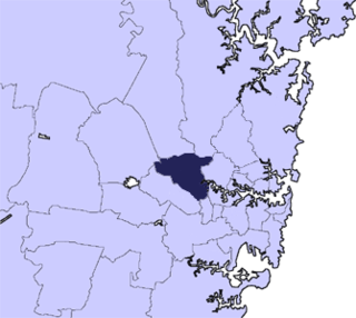
Hornsby Shire is a local government area situated in Northern Sydney, as well as parts of the Hills District, in the state of New South Wales, Australia. The shire stretches from the M2 Hills Motorway in the south to the Hawkesbury River town of Wisemans Ferry, some 53 kilometres (33 mi) to the north, making it the largest local government council in the Greater Sydney Metropolitan region by total area. As of the 2016 census the shire had an estimated population of 142,667.

<span class="mw-page-title-main">Jerilderie Shire</span> Former local government area in New South Wales, Australia

Jerilderie Shire was a local government area in the Riverina region of southern New South Wales, Australia. The Shire was located adjacent to the Newell Highway. The Shire was declared in 1918 after the amalgamation of the former Municipality of Jerilderie and Wunnamurra Shire. It was dissolved in 2016 after its amalgamation with Murrumbidgee Shire to create Murrumbidgee Council

<span class="mw-page-title-main">Murrumbidgee Shire</span> Former local government area in New South Wales, Australia

Murrumbidgee Shire was a local government area in the Riverina region of south western New South Wales, Australia. The Shire was located adjacent to the Murrumbidgee River and the Newell Highway.

<span class="mw-page-title-main">City of Parramatta</span> Local government area in New South Wales, Australia

The City of Parramatta, also known as Parramatta Council, is a local government area located to the west and north-west of Sydney CBD in the Greater Western Sydney region. Parramatta Council is situated between the City of Ryde and Cumberland, where the Cumberland Plain meets the Hornsby Plateau, approximately 25 kilometres (16 mi) west of the Sydney central business district, in New South Wales, Australia. The city occupies an area of 84 square kilometres (32 sq mi) spanning across suburbs in Greater Western Sydney including the Hills District, and a small section of Northern Sydney to the far north east of its area. According to the 2016 census, City of Parramatta had an estimated population of 226,149. The city houses the Parramatta central business district which is one of the key suburban employment destinations for the region of Greater Western Sydney.

<span class="mw-page-title-main">Leeton Shire</span> Local government area in New South Wales, Australia

Leeton Shire is a local government area in the Riverina region of New South Wales, Australia. The Shire is located adjacent to the Murrumbidgee River and falls within the Murrumbidgee Irrigation Area.

<span class="mw-page-title-main">Narromine Shire</span> Local government area in New South Wales, Australia

Narromine Shire is a local government area in the Orana region of New South Wales, Australia. The Shire is located adjacent to the Mitchell Highway and the Main Western railway line. It was formed on 1 January 1981 from the amalgamation of the Municipality of Narromine and Timbrebongie Shire resulting from the Local Government Areas Amalgamation Act 1980.

<span class="mw-page-title-main">Bogan Shire</span> Local government area in New South Wales, Australia

Bogan Shire is a local government area in the Orana region of New South Wales, Australia. The Shire is located adjacent to the Mitchell and Barrier highways and its only significant town is Nyngan.

<span class="mw-page-title-main">Weddin Shire</span> Local government area in New South Wales, Australia

Weddin Shire is a local government area in the Central West region of New South Wales, Australia. The shire's major town is Grenfell and it also includes the small towns of Caragabal, Greenethorpe and Quandialla.

<span class="mw-page-title-main">Carrathool Shire</span> Local government area in New South Wales, Australia

The Carrathool Shire is a local government area that borders both the Riverina and Far West regions of New South Wales, Australia. The Shire comprises 18,933 square kilometres (7,310 sq mi) and is located adjacent to the Mid-Western Highway and north of the Sturt Highway.

<span class="mw-page-title-main">Central Darling Shire</span> Local government area in New South Wales, Australia

Central Darling Shire is a local government area in the Far West region of New South Wales, Australia. The Shire is located adjacent to the Barrier Highway. Central Darling Shire was constituted in 1959 and at 53,511 square kilometres (20,661 sq mi), it is the largest incorporated local government area in New South Wales.

<span class="mw-page-title-main">Berrigan Shire</span> Local government area in New South Wales, Australia

Berrigan Shire is a local government area in the southern Riverina region of New South Wales, Australia. The Shire lies on the New South Wales State border with Victoria formed by the Murray River. The Shire is adjacent to the Newell and Riverina Highways. The Shire is a mainly agricultural region, with dairying, cattle raising, woolgrowing and cropping the main activities. The vast majority of the Shire is irrigated. Tourism is another major activity, concentrated on the river towns of Tocumwal and Barooga.

<span class="mw-page-title-main">Narrabri Shire</span> Local government area in New South Wales, Australia

Narrabri Shire is a local government area in the North West Slopes region of New South Wales, Australia. The Shire is located adjacent to the Namoi River and the Newell and Kamilaroi Highways.

<span class="mw-page-title-main">Ballina Shire</span> Local government area in New South Wales, Australia

Ballina Shire is a local government area in the Northern Rivers region of New South Wales, Australia. The Shire was formed on 1 January 1977 by the amalgamation of the Municipality of Ballina and Tintenbar Shire. The Shire is located adjacent to the Tasman Sea and the Pacific Highway. The council seat is located in the town of Ballina. The population of the Ballina Shire area was 46,850 in 2022.

<span class="mw-page-title-main">City of Coffs Harbour</span> Local government area in New South Wales, Australia

The City of Coffs Harbour is a local government area in the mid north coast region of New South Wales, Australia. The area under administration is 1,175 square kilometres (454 sq mi), expanded in 2004 to take in parts of the former Pristine Waters local government area.

<span class="mw-page-title-main">Walcha Shire</span> Local government area in New South Wales, Australia

Walcha Shire is a local government area located in the New England region of New South Wales, Australia. The Shire is situated adjacent to the junction of the Oxley Highway and Thunderbolts Way and is 20 kilometres (12 mi) east of the Main North railway line passing through Walcha Road. The shire was formed on 1 June 1955 through the amalgamation of Apsley Shire and the Municipality of Walcha.

<span class="mw-page-title-main">Tenterfield Shire</span> Local government area in New South Wales, Australia

Tenterfield Shire is a local government area located in the New England region of New South Wales, Australia. The Shire is situated adjacent to the New England Highway.

<span class="mw-page-title-main">Lockhart Shire</span> Local government area in New South Wales, Australia

Lockhart Shire is a local government area in the Riverina region of New South Wales, Australia. The Shire was created in 1906 and is an agricultural and pastoral area.

<span class="mw-page-title-main">Hay Shire</span> Local government area in New South Wales, Australia

The Hay Shire is a local government area in the Riverina area of south-western New South Wales, Australia. The Shire comprises 11,326 square kilometres (4,373 sq mi) and is located adjacent to the Sturt, Mid-western and Cobb Highways. The area includes the towns of Hay, Booligal and Maude.

<span class="mw-page-title-main">Coonamble Shire</span> Local government area in New South Wales, Australia

Coonamble Shire is a local government area in the Orana region of New South Wales, Australia. The Shire is located adjacent to the Castlereagh Highway and the Castlereagh River.

References

  1. 1 2 Australian Bureau of Statistics (27 June 2017). "Murrumbidgee (A)". 2016 Census QuickStats. Retrieved 8 December 2017. OOjs UI icon edit-ltr-progressive.svg
  2. "3218.0 – Regional Population Growth, Australia, 2017–18". Australian Bureau of Statistics. 27 March 2019. Retrieved 27 March 2019. Estimated resident population (ERP) at 30 June 2018.
  3. 1 2 3 4 "Murrumbidgee Council". Stronger Councils. Government of New South Wales. 12 May 2016. Retrieved 13 May 2016.
  4. Bunn, Anthony (21 September 2017). "Ruth McRae becomes first mayor of Murrumbidgee Shire following amalgamation with Jerilderie". Border Mail. Retrieved 21 September 2017.
  5. "Council Minutes and Business Papers | Murrumbidgee Council". www.murrumbidgee.nsw.gov.au. Retrieved 11 May 2020.
  6. Australian Bureau of Statistics (9 March 2006). "Murrumbidgee (A)". 2001 Census QuickStats. Retrieved 31 May 2021. OOjs UI icon edit-ltr-progressive.svg
  7. Australian Bureau of Statistics (25 October 2007). "Murrumbidgee (A)". 2006 Census QuickStats. Retrieved 31 May 2021.
  8. Australian Bureau of Statistics (31 October 2012). "Murrumbidgee (A)". 2011 Census QuickStats. Retrieved 31 May 2021. OOjs UI icon edit-ltr-progressive.svg
  9. "Warangesda Aboriginal Mission and Station". New South Wales State Heritage Register . Department of Planning & Environment. H01810. Retrieved 18 May 2018. CC BY icon.svg Text is licensed by State of New South Wales (Department of Planning and Environment) under CC-BY 4.0 licence .
  10. "Jerilderie Railway Station Group". New South Wales State Heritage Register . Department of Planning & Environment. H01658. Retrieved 18 May 2018. CC BY icon.svg Text is licensed by State of New South Wales (Department of Planning and Environment) under CC-BY 4.0 licence .
  11. "Murrumbidgee – Jerilderie Ward". NSW Local Council Elections 2017. NSW Electoral Commission. Retrieved 15 September 2017.
  12. "Murrumbidgee – Murrumbidgee Ward". NSW Local Council Elections 2017. NSW Electoral Commission. Retrieved 15 September 2017.
  13. "Murrumbidgee – Murrumbidgee East Ward". NSW Electoral Commission. Retrieved 15 September 2017.
  14. "Our Councillors | Murrumbidgee Council". www.murrumbidgee.nsw.gov.au. Retrieved 11 May 2020.