Gilgandra Shire

Last updated

Gilgandra Shire
New South Wales
Gilgandra LGA NSW.png
Location in New South Wales
Coordinates 31°42′S148°41′E / 31.700°S 148.683°E / -31.700; 148.683 Coordinates: 31°42′S148°41′E / 31.700°S 148.683°E / -31.700; 148.683
Population
 • Density0.87593/km2 (2.2686/sq mi)
Established1906
Area4,836 km2 (1,867.2 sq mi)
MayorDoug Batten (Independent)
Council seat Gilgandra
Region Orana
State electorate(s) Barwon
Federal division(s) Parkes
Gilgandra Shire Council Logo.png
Website Gilgandra Shire
LGAs around Gilgandra Shire:
Warren Coonamble Warrumbungle
Warren Gilgandra Shire Warrumbungle
Narromine Dubbo Warrumbungle

Gilgandra Shire is a local government area in the Orana region of New South Wales, Australia. The Shire is located adjacent to the junction of the Newell, Oxley and Castlereagh highways and can be reached in about six hours by car from Sydney CBD. The Shire lies on the Castlereagh River and includes part of the Warrumbungles National Park. The shire was constituted in 1906.

Contents

The mayor of Gilgandra Shire Council is Cr. Doug Batten, an independent politician.

Settlements and geography

Gilgandra Shire includes Gilgandra, Balladoran and Curban.

The geography of the Gilgandra Shire is very flat. The soil is composed mostly of sand, making it very porous and difficult to grow certain plants. The weather is hot and dry, reaching 40 °C (104 °F) for consecutive days during summer.[ citation needed ]

Demographics

Selected historical census data for Gilgandra Shire local government area
Census year2011 [3] 2016 [1]
PopulationEstimated residents on census night 4,386Decrease2.svg 4,236
LGA rank in terms of size within New South Wales 115thSteady2.svg 115th
% of New South Wales population
% of Australian population
Cultural and language diversity
Ancestry,
top responses
English
Australian
Italian
Chinese
Irish
Language,
top responses
(other than English)
Italian
Mandarin
Cantonese
Korean
Greek
Religious affiliation
Religious affiliation,
top responses
Catholic
No religion
Anglican
Eastern Orthodox
Buddhism
Median weekly incomes
Personal income Median weekly personal incomeA$
% of Australian median income
Family incomeMedian weekly family income
% of Australian median income
Household incomeMedian weekly household income
% of Australian median income

Heritage listings

Gilgandra Shire has a number of heritage-listed sites, including:

Council

Current composition and election method

Gilgandra Shire Council is composed of nine councillors elected proportionally as a single ward. All councillors are elected for a fixed four-year term of office. The mayor is elected by the councillors at the first meeting of the council. The most recent election was held on 10 September 2016, and the makeup of the council is as follows: [6]

PartyCouncillors
  Independents 9
Total9

The current Council, elected in 2016, in order of election, is: [6]

CouncillorPartyNotes
Doug Batten  Independent Mayor [7]
Gregory Peart Independent
Brian Mockler Unaligned
Ash Walker IndependentDeputy Mayor [7]
Noel Wrigley Independent
Deidrie Naden Independent
Noel Mudford Independent
Gina Johnson Independent
Susan Baker Independent

Related Research Articles

<span class="mw-page-title-main">Ku-ring-gai Council</span> Local government area in New South Wales, Australia

Ku-ring-gai Council is a local government area in Northern Sydney, in the state of New South Wales, Australia. The area is named after the Guringai Aboriginal people who were thought to be the traditional owners of the area. More contemporary research suggests that this was not the case.

<span class="mw-page-title-main">Upper Hunter Shire</span> Local government area in New South Wales, Australia

The Upper Hunter Shire is a local government area in the Upper Hunter Region of New South Wales, Australia. The Shire was formed in May 2004 from the Scone Shire and parts of Murrurundi and Merriwa shires.

<span class="mw-page-title-main">Upper Lachlan Shire</span> Local government area in New South Wales, Australia

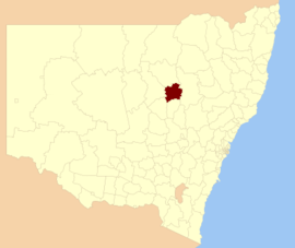
Upper Lachlan Shire is a local government area in the Southern Tablelands region of New South Wales, Australia. The Shire was formed in February 2004 from Crookwell Shire and parts of Mulwaree, Gunning and Yass Shires.

<span class="mw-page-title-main">The Hills Shire</span> Local government area in New South Wales, Australia

The Hills Shire is a local government area in the Greater Sydney region of Sydney, New South Wales, Australia. The suburb is north-west of the Sydney central business district, and encompasses 401 square kilometres (155 sq mi) stretching from the M2 Hills Motorway in the south to Wiseman's Ferry on the Hawkesbury River in the north. The Hills Shire had a population of 157,243 as at the 2016 census.

<span class="mw-page-title-main">Hornsby Shire</span> Local government area in New South Wales, Australia

Hornsby Shire is a local government area situated in Northern Sydney, as well as parts of the Hills District, in the state of New South Wales, Australia. The shire stretches from the M2 Hills Motorway in the south to the Hawkesbury River town of Wisemans Ferry, some 53 kilometres (33 mi) to the north, making it the largest local government council in the Greater Sydney Metropolitan region by total area. As of the 2016 census the shire had an estimated population of 142,667.

<span class="mw-page-title-main">Warrumbungle Shire</span> Local government area in New South Wales, Australia

The Warrumbungle Shire is a local government area in the central western region of New South Wales, Australia. The Shire is traversed by the Newell Highway. The Warrumbungle mountain range and Warrumbungles National Park are major tourist attractions for the Shire. Its capital is Coonabarabran, a city in the southwest.

<span class="mw-page-title-main">City of Penrith</span> Local government area in New South Wales, Australia

The City of Penrith is a local government area in the state of New South Wales, Australia. The seat of the city is located in Penrith, located about 50 kilometres (31 mi) west of Sydney's central business district. It occupies part of the traditional lands of the Darug people. First incorporated as a municipality on 12 May 1871, on 1 January 1949, the municipalities of Penrith, St Marys and Castlereagh and part of the Nepean Shire amalgamated to form a new Municipality of Penrith. Penrith was declared a City on 21 October 1959, and expanded westwards to include Emu Plains and Emu Heights, formerly part of the City of Blue Mountains, on 25 October 1963. As at the 2016 census the City of Penrith had an estimated population of 196,066.

<span class="mw-page-title-main">Leeton Shire</span> Local government area in New South Wales, Australia

Leeton Shire is a local government area in the Riverina region of New South Wales, Australia. The Shire is located adjacent to the Murrumbidgee River and falls within the Murrumbidgee Irrigation Area.

<span class="mw-page-title-main">Weddin Shire</span> Local government area in New South Wales, Australia

Weddin Shire is a local government area in the Central West region of New South Wales, Australia. The shire's major town is Grenfell and it also includes the small towns of Caragabal, Greenethorpe and Quandialla.

<span class="mw-page-title-main">Parkes Shire</span> Local government area in New South Wales, Australia

Parkes Shire is a local government area in the Central West region of New South Wales, Australia. The Shire is located adjacent to the Broken Hill railway line and the Newell Highway.

<span class="mw-page-title-main">Muswellbrook Shire</span> Local government area in New South Wales, Australia

Muswellbrook Shire is a local government area in the Upper Hunter region of New South Wales, Australia. The Shire is situated adjacent to the New England Highway and the Hunter railway line.

<span class="mw-page-title-main">Wentworth Shire</span> Local government area in New South Wales, Australia

Wentworth Shire is a local government area in the far south-west Riverina region of New South Wales, Australia. This Shire is located adjacent to the Murray and Darling Rivers. The Shire's major roads are the Sturt and the Silver City Highways. The Shire includes the towns of Wentworth, Buronga, Gol Gol, Dareton and Pooncarie.

<span class="mw-page-title-main">Armidale Regional Council</span> Local government area in New South Wales, Australia

The Armidale Region is a local government area in the New England and Northern Tablelands regions of New South Wales, Australia. This area was formed in 2016 from the merger of the Armidale Dumaresq Shire with the surrounding Guyra Shire.

<span class="mw-page-title-main">Federation Council, New South Wales</span> Local government area in New South Wales, Australia

The Federation Council is a local government area located in the Riverina region of New South Wales, Australia. This area was formed in 2016 from the merger of the Corowa Shire with its neighbouring Urana Shire.

<span class="mw-page-title-main">Murrumbidgee Council</span> Local government area in New South Wales, Australia

Murrumbidgee Council is a local government area in the Riverina region of New South Wales, Australia. This area was formed in 2016 from the merger of the Murrumbidgee Shire with the neighbouring Jerilderie Shire.

<span class="mw-page-title-main">Snowy Monaro Regional Council</span> Local government area in New South Wales, Australia

The Snowy Monaro Regional Council is a local government area located in the Snowy Mountains and Monaro regions of New South Wales, Australia. The council was formed on 12 May 2016 through a forced merger of the Bombala, Cooma-Monaro and Snowy River shires.

<span class="mw-page-title-main">Snowy Valleys Council</span> Local government area in New South Wales, Australia

The Snowy Valleys Council is a local government area located in the South West Slopes region of New South Wales, Australia. This area was formed in 2016 from the merger of the Tumut Shire with the neighbouring Tumbarumba Shire.

<span class="mw-page-title-main">Murray River Council</span> Local government area in New South Wales, Australia

The Murray River Council is a local government area in the Riverina region of New South Wales, Australia. This area was formed in 2016 from the merger of Murray Shire with Wakool Shire.

<span class="mw-page-title-main">Dubbo Regional Council</span> Local government area in New South Wales, Australia

The Dubbo Regional Council is a local government area located in the Central West and Orana regions of New South Wales, Australia. The council was formed on 12 May 2016 through a merger of the City of Dubbo and Wellington Council as part of a widespread council amalgamation program. It was initially named Western Plains Regional Council for almost four months, and its name was changed to Dubbo Regional Council on 7 September 2016.

Corduroy Road Ruin Historic Site is a heritage-listed former stagecoach route and now disused road at East Coonamble Road, Curban, Gilgandra Shire, New South Wales, Australia. It was designed by n/a and built from 1850 to 1923. It is also known as Cobb & Co route. The property is owned by Gilgandra Shire Council. It was added to the New South Wales State Heritage Register on 5 October 2018.

References

  1. 1 2 Australian Bureau of Statistics (27 June 2017). "Gilgandra (A)". 2016 Census QuickStats. Retrieved 7 July 2017. OOjs UI icon edit-ltr-progressive.svg
  2. "3218.0 – Regional Population Growth, Australia, 2017–18". Australian Bureau of Statistics. 27 March 2019. Archived from the original on 27 March 2019. Retrieved 27 March 2019. Estimated resident population (ERP) at 30 June 2018.
  3. Australian Bureau of Statistics (31 October 2012). "Gilgandra (A)". 2011 Census QuickStats. Retrieved 24 October 2012. OOjs UI icon edit-ltr-progressive.svg
  4. "Corduroy Road Ruin Historic Site". New South Wales State Heritage Register . Department of Planning & Environment. H02015. Retrieved 18 February 2020. CC-BY icon.svg Text is licensed by State of New South Wales (Department of Planning and Environment) under CC-BY 4.0 licence .
  5. "St. Ambrose Church". New South Wales State Heritage Register . Department of Planning & Environment. H01853. Retrieved 18 May 2018. CC-BY icon.svg Text is licensed by State of New South Wales (Department of Planning and Environment) under CC-BY 4.0 licence .
  6. 1 2 "Gilgandra Shire Council: Summary of First Preference Votes for each Candidate". Local Government Elections 2016. Electoral Commission of New South Wales. 17 September 2016. Archived from the original on 6 November 2016. Retrieved 6 November 2016.
  7. 1 2 "Councillors". Your Council. Gilgandra Shire Council. Archived from the original on 6 November 2016. Retrieved 6 November 2016.