City of Shellharbour

Last updated • 3 min readFrom Wikipedia, The Free Encyclopedia

City of Shellharbour
New South Wales
Shellharbour LGA location map.svg
Location in the Illawarra
Coordinates 34°35′S150°52′E / 34.583°S 150.867°E / -34.583; 150.867
Population
 • Density518.9/km2 (1,344/sq mi)
Established1859
Area147 km2 (56.8 sq mi)
MayorChris Homer
Council seat Shellharbour City Centre [3]
Region Illawarra
State electorate(s)
Federal division(s)
Shellharbour City Council Logo.png
Website City of Shellharbour
LGAs around City of Shellharbour:
Wingecarribee Wollongong Tasman Sea
Wingecarribee City of Shellharbour Tasman Sea
Wingecarribee Kiama Tasman Sea

The City of Shellharbour is a local government area in the Illawarra region of New South Wales, Australia. The city is located about 100 kilometres (62 mi) south of Sydney and covers the southern suburbs of the Wollongong urban area centred on Shellharbour and it had an estimated population of 68,460 at the 2016 census.

Contents

The area is bordered by the City of Wollongong to the north, with the boundary being the Lake Illawarra entrance (and the suburb of Lake Illawarra) and Macquarie Rivulet (Albion Park Rail). The Municipality of Kiama is to the south of the City of Shellharbour.

The mayor of the Shellharbour City Council is Cr. Chris Homer. [4]

History

Indigenous occupation of the area, particularly of Bass Point, can be traced back to 17,000 BCE.[ citation needed ]

The area was discovered by Europeans Bass and Flinders in 1796. [5] Free settlers began arriving between 1817 and 1831 and the township was founded in 1851. The Shellharbour (Municipal) Council was constituted on 4 June 1859, and was gazetted as a City in 1996. In May 2009, Shellharbour City Council celebrated its sesquicentenary. [6]

A 2015 review of local government boundaries recommended that the City of Shellharbour merge with the City of Wollongong to form a new council with an area of 831 square kilometres (321 sq mi) and support a population of approximately 276,000. [7] On 13 February 2017, the New South Wales Government decided not to forcibly amalgamate Shellharbour Council with Wollongong Council.

Heritage listings

The City of Shellharbour has a number of heritage-listed sites, including:

Suburbs

The City of Shellharbour contains the following suburbs and localities:

Council

Current composition and election method

As of 2023, Shellharbour City Council is composed of eight councillors elected proportionally in four wards.. Under the Local Government (Shellharbour and Wollongong Elections) Act, 2011 (NSW), councillors are elected to hold office until September 2024. Since 2021, the mayor has been directly elected.

The current council, elected in 2021, is:

WardCouncillorParty
Mayor Chris Homer Independent
A Ward Kellie MarshKellie Marsh Independents
 Maree Edwards Labor
B Ward Moira Hamilton Labor
 John DaveyLocal Voice
C Ward Colin Gow Independent
 Lou Stefanovski Labor
D Ward Jacqueline Graf Independent
 Rob Petreski Labor

Election results

2024

2024 New South Wales local elections: Shellharbour
PartyVotes %SwingSeatsChange
 Chris Homer Independents
  Labor
 Kane Murphy Independents
 Kellie Marsh Independents
  Independents
 Formal votes
 Informal votes
 Total8
 Registered voters / turnout

2021

2021 New South Wales local elections: Shellharbour [12] [13]
PartyVotes %SwingSeatsChange
  Labor 21,19961.8+12.54Increase2.svg 1
 Kellie Marsh Independents8,74625.51
  Independent 5,58316.32
 Local Voice3,45410.11
 Community Voice3,41610.00
 Formal votes34,28294.9
 Informal votes1,8455.1
 Total votes36,127100.0
 Registered voters / turnout55,82564.71

Attractions

Shellharbour City has many attractions for family entertainment and recreation. In Albion Park Rail there is a Light Rail Museum and steam trains, Historical Aircraft Restoration Society (HARS) Museum, and Albion Oval; a local sports ground. Shellharbour Village, the beach and playground are also popular attractions. Excellent fishing at Lake Illawarra and superb surfing at Warilla beach. A cycleway goes from Oak Flats to Barrack Point. The Macquarie Valley (Shellharbour) provides scenic views and also includes the Macquarie Pass National Park.

There are various beaches in Shellharbour such as the Blacks Beach, Shellharbour North Beach, Shellharbour South Beach, Warilla Central Beach, Warilla North Beach, and Warilla South Beach which are some of the major crowd pullers. [14]

See also

Related Research Articles

<span class="mw-page-title-main">Wollongong</span> City in New South Wales, Australia

Wollongong is a city located in the Illawarra region of New South Wales, Australia. The name is believed to originate from the Dharawal language, meaning either 'five islands/clouds', 'ground near water' or 'sound of the sea'. Wollongong lies on the narrow coastal strip between the Illawarra Escarpment and the Pacific Ocean, 85 kilometres south of central Sydney. Wollongong had an estimated urban population of 302,739 at June 2018, making it the third-largest city in New South Wales after Sydney and Newcastle and the tenth-largest city in Australia by population. The city's current Lord Mayor is Gordon Bradbery AM who was elected in 2021.

<span class="mw-page-title-main">Illawarra</span> Region in New South Wales, Australia

The Illawarra is a coastal region in the southeast of the Australian state of New South Wales. It is situated immediately south of Sydney and north of the South Coast region. It encompasses the two cities of Wollongong, Shellharbour and the coastal town of Kiama. Wollongong is the largest city of the Illawarra with a population of 240,000, then Shellharbour with a population of 70,000 and Kiama with a population of 10,000. These three cities have their own suburbs. Wollongong stretches from Otford in the north to Windang in the south, with Maddens Plains and Cordeaux in the west.

<span class="mw-page-title-main">Albion Park, New South Wales</span> Suburb of Illawarra, New South Wales, Australia

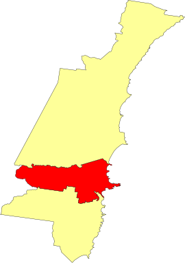
Albion Park is a suburb situated in the Macquarie Valley in the City of Shellharbour, which is in turn one of the three local government areas that comprise the Wollongong Metropolitan Area, New South Wales, Australia. Although it is surrounded by a 'green belt' of farms, Albion Park had a population of 13,316 at the 2016 census.

<span class="mw-page-title-main">Albion Park Rail, New South Wales</span> Suburb of City of Shellharbour, New South Wales, Australia

Albion Park Rail is a suburb of Shellharbour, Australia situated in the Macquarie Valley (Shellharbour). The South Coast railway line was opened to the railway station and Bombo in 1887. At the time the nearest town was Albion Park, several kilometres away. Over time, houses were built around the railway station, and Albion Park Rail developed into a town in its own right, and with its own name.

<span class="mw-page-title-main">Dunmore railway station</span> Historic site in New South Wales, Australia

Dunmore railway station is a heritage-listed former railway station that was located on the South Coast railway line in Dunmore, City of Shellharbour, New South Wales, Australia. The station served the southern Wollongong suburb of Dunmore and indirectly Shellharbour and opened on 9 November 1887. The weatherboard station on Platform 2 dates from 1887. It is also known as the Shellharbour Railway Station Group, Shellharbour railway station and Dunmore Railway Station. The property was added to the New South Wales State Heritage Register on 2 April 1999.

<span class="mw-page-title-main">Oak Flats railway station</span> Railway station in New South Wales, Australia

Oak Flats railway station is a single-platform intercity train station located in Oak Flats, New South Wales, Australia, on the South Coast railway line. The station serves NSW TrainLink trains travelling south to Kiama and north to Wollongong and Sydney. Together with the Dunmore and later Shellharbour Junction stations, Oak Flats has long served as the rail connection for the coastal suburbs of the City of Shellharbour.

<span class="mw-page-title-main">Albion Park railway station</span> Railway station in New South Wales, Australia

Albion Park railway station is a heritage-listed railway station located on the South Coast railway line on the Princes Highway in Albion Park Rail, New South Wales, Australia. The station was designed by New South Wales Government Railways and built during 1887 by William Monie & Company, with the single line railway line built by David Proudfoot and Thomas Logan. The complex is also known as the Albion Park Railway Station Group. The property was added to the New South Wales State Heritage Register on 2 April 1999. The station is located close to Shellharbour Airport.

<span class="mw-page-title-main">Unanderra railway station</span> Railway station in New South Wales, Australia

Unanderra railway station is located on the South Coast railway line in the Wollongong suburb of Unanderra, New South Wales, Australia.

<span class="mw-page-title-main">Warilla, New South Wales</span> Suburb of City of Shellharbour, New South Wales, Australia

Warilla is a seaside suburb of the City of Shellharbour, Australia within the Wollongong urban area. It is one of the more established areas and is between the suburbs of Mount Warrigal in the west, Barrack Heights and Barrack Point in the south and Lake Illawarra in the north.

Warilla High School is a government-funded co-educational comprehensive secondary day school, located in Barrack Heights, a suburb of the City of Shellharbour, in the Illawarra region of New South Wales, Australia.

<span class="mw-page-title-main">Shellharbour Junction railway station</span> Railway station in New South Wales, Australia

Shellharbour Junction railway station is a railway station located in Dunmore in the City of Shellharbour, New South Wales, Australia, on the Illawarra railway line. The station is served by NSW TrainLink South Coast Line trains traveling south to Kiama and north to Wollongong and Sydney. Premier Illawarra operates a connecting bus service from the station to Shellharbour.

Shellharbour is an electoral district of the Legislative Assembly in the Australian state of New South Wales. It is represented by Anna Watson who won Labor preselection after the former member Lylea McMahon decided not to contest the 2011 election.

<span class="mw-page-title-main">Shellharbour Airport</span> Airport serving the Illawarra region and Wollongong, Australia

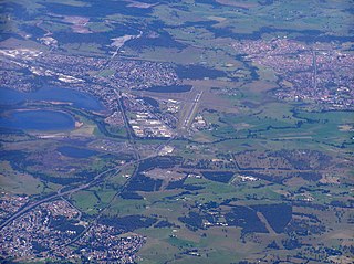
Shellharbour Airport, formerly Illawarra Regional Airport, also referred as Albion Park Aerodrome or Wollongong Airport, is an airport located in Albion Park Rail, New South Wales, Australia.

<span class="mw-page-title-main">Flinders, New South Wales</span> Suburb of Shellharbour, New South Wales, Australia

Flinders is a southern suburb of Shellharbour, located in the Illawarra region of New South Wales, Australia. Flinders is located approximately 111 kilometres south-southwest of New South Wales' capital city of Sydney. Flinders is close to a number of beaches and to and over 60 hectares of green open spaces including bush reserves, waterways and landscaped parks. Flinders adjoins neighbouring suburbs of Shellharbour, Shell Cove, Blackbutt and Shell Heights.

Barrack Point is a seaside suburb of the City of Shellharbour, New South Wales, Australia which sits within the southern Wollongong urban area. Surrounding suburbs are Warilla to the north, Barrack Heights to the west, and Shellharbour to the south.

The Macquarie Valley, also known as Albion Park, Rural West or Western Valley, is an area located in the Shellharbour local government area in the Illawarra region of New South Wales, Australia.

<span class="mw-page-title-main">Dunmore, New South Wales</span> Suburb of Shellharbour, New South Wales, Australia

Dunmore is a largely rural suburb of Shellharbour City in New South Wales, Australia. Dunmore is bisected north to south by the South Coast railway line and the Princes Highway.

<span class="mw-page-title-main">Bass Point Reserve</span> Historic site in New South Wales, Australia

Bass Point Reserve is a heritage-listed former cedar timber industry, Aboriginal camping, meeting place, pastoral property and basalt mine and now nature conservation and passive recreation area located at Boollwarroo Parade, Shell Cove in the Illawarra region of New South Wales, Australia. It is also known as Long Point. The property is owned by Department of the Environment and Shellharbour City Council. It was added to the New South Wales State Heritage Register on 18 January 2013.

Toongla is a heritage-listed former residence and dairy farm and now residence at 41 Tullimbar Road, Albion Park in the City of Shellharbour local government area in the Illawarra region of New South Wales, Australia. It was built during 1873. The property is privately owned. It was added to the New South Wales State Heritage Register on 2 April 1999.

References

  1. Australian Bureau of Statistics (28 June 2022). "Shellharbour". 2021 Census QuickStats. Retrieved 24 February 2023. OOjs UI icon edit-ltr-progressive.svg
  2. "3218.0 – Regional Population Growth, Australia, 2017–18". Australian Bureau of Statistics . 27 March 2019. Archived from the original on 27 March 2019. Retrieved 27 March 2019. Estimated resident population (ERP) at 30 June 2018.
  3. "Shellharbour City Council". Department of Local Government . Archived from the original on 6 September 2006. Retrieved 26 November 2006.
  4. shh-admin (4 December 2018). "Chris Homer (Mayor)". Shellharbour Council. Retrieved 2 March 2022.
  5. "Bass and Flinders". Australian History. 2012. Archived from the original on 20 March 2012. Retrieved 5 October 2012.{{cite web}}: CS1 maint: unfit URL (link)
  6. "Our History". Shellharbour City Council. Archived from the original on 8 February 2008. Retrieved 16 March 2008.
  7. "Merger proposal: Shellharbour City Council, Wollongong City Council" (PDF). Government of New South Wales. January 2016. p. 7. Archived (PDF) from the original on 10 March 2016. Retrieved 10 March 2016 via Amazon Web Services.
  8. "Toongla". New South Wales State Heritage Register . Department of Planning & Environment. H00556. Retrieved 18 May 2018. CC BY icon.svg Text is licensed by State of New South Wales (Department of Planning and Environment) under CC-BY 4.0 licence .
  9. "Albion Park Railway Station Group". New South Wales State Heritage Register . Department of Planning & Environment. H01072. Retrieved 18 May 2018. CC BY icon.svg Text is licensed by State of New South Wales (Department of Planning and Environment) under CC-BY 4.0 licence .
  10. "Shellharbour Railway Station Group". New South Wales State Heritage Register . Department of Planning & Environment. H01245. Retrieved 18 May 2018. CC BY icon.svg Text is licensed by State of New South Wales (Department of Planning and Environment) under CC-BY 4.0 licence .
  11. "Bass Point Reserve". New South Wales State Heritage Register . Department of Planning & Environment. H01896. Retrieved 18 May 2018. CC BY icon.svg Text is licensed by State of New South Wales (Department of Planning and Environment) under CC-BY 4.0 licence .
  12. "City of Shellharbour". ABC News. 4 December 2021. Archived from the original on 6 May 2024. Retrieved 16 September 2024.
  13. "As we approach the last day of pre polls tomorrow I encourage those who have not voted yet to come down to Bing Lee at Warilla or the Scout Hall at Station Rd Albion Park and get the job done before Saturday". Facebook. Community Voice for Shellharbour - Peter Moran and Tammy Larkings. 2 December 2021. Archived from the original on 16 September 2024. Retrieved 16 September 2024.
  14. "Beaches and pools". Shellharbour City Council. 7 November 2018. Archived from the original on 14 May 2019. Retrieved 21 May 2019.