
Macquarie Pass National Park is a national park in New South Wales, Australia, 90 km southwest of Sydney. It is located around the pass of the same name, which is on the Illawarra Highway and part of the Illawarra escarpment.

Wollongong is a city located in the Illawarra region of New South Wales, Australia. The name is believed to originate from the Dharawal language, meaning either 'five islands/clouds', 'ground near water' or 'sound of the sea'. Wollongong lies on the narrow coastal strip between the Illawarra Escarpment and the Pacific Ocean, 85 kilometres south of central Sydney. Wollongong had an estimated urban population of 302,739 at June 2018, making it the third-largest city in New South Wales after Sydney and Newcastle and the tenth-largest city in Australia by population. The city's current Lord Mayor is Gordon Bradbery AM who was elected in 2021.

The Illawarra is a coastal region in the southeast of the Australian state of New South Wales. It is situated immediately south of Sydney and north of the South Coast region. It encompasses the two cities of Wollongong, Shellharbour and the coastal town of Kiama. Wollongong is the largest city of the Illawarra with a population of 240,000, then Shellharbour with a population of 70,000 and Kiama with a population of 10,000. These three cities have their own suburbs. Wollongong stretches from Otford in the north to Windang in the south, with Maddens Plains and Cordeaux in the west.
Shellharbour is a suburb located in the Illawarra region of New South Wales, Australia. It also gives its name to the local government area, City of Shellharbour, and its central business district, Shellharbour City Centre.

Princes Motorway is a 62-kilometre (39 mi) predominantly dual carriage untolled motorway that links Sydney to Wollongong and further south through the Illawarra region to Oak Flats. Part of the Australian Highway 1 network, the motorway is designated route M1.
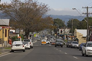
Albion Park is a suburb situated in the Macquarie Valley in the City of Shellharbour, which is in turn one of the three local government areas that comprise the Wollongong Metropolitan Area, New South Wales, Australia. Although it is surrounded by a 'green belt' of farms, Albion Park had a population of 13,316 at the 2016 census.
Albion Park Rail is a suburb of Shellharbour, Australia situated in the Macquarie Valley (Shellharbour). The South Coast railway line was opened to the railway station and Bombo in 1887. At the time the nearest town was Albion Park, several kilometres away. Over time, houses were built around the railway station, and Albion Park Rail developed into a town in its own right, and with its own name.

Oak Flats railway station is a single-platform intercity train station located in Oak Flats, New South Wales, Australia, on the South Coast railway line. The station serves NSW TrainLink trains travelling south to Kiama and north to Wollongong and Sydney. Together with the Dunmore and later Shellharbour Junction stations, Oak Flats has long served as the rail connection for the coastal suburbs of the City of Shellharbour.

Albion Park railway station is a heritage-listed railway station located on the South Coast railway line on the Princes Highway in Albion Park Rail, New South Wales, Australia. The station was designed by New South Wales Government Railways and built during 1887 by William Monie & Company, with the single line railway line built by David Proudfoot and Thomas Logan. The complex is also known as the Albion Park Railway Station Group. The property was added to the New South Wales State Heritage Register on 2 April 1999. The station is located close to Shellharbour Airport.

The City of Shellharbour is a local government area in the Illawarra region of New South Wales, Australia. The city is located about 100 kilometres (62 mi) south of Sydney and covers the southern suburbs of the Wollongong urban area centred on Shellharbour and it had an estimated population of 68,460 at the 2016 census.

Oak Flats is a suburb of Shellharbour, New South Wales, Australia situated on the south western shores of Lake Illawarra and within the Illawarra region of New South Wales. It is a residential area, which had a population of 6,415 at the 2016 census.

Shellharbour Junction railway station is a railway station located in Dunmore in the City of Shellharbour, New South Wales, Australia, on the Illawarra railway line. The station is served by NSW TrainLink South Coast Line trains traveling south to Kiama and north to Wollongong and Sydney. Premier Illawarra operates a connecting bus service from the station to Shellharbour.

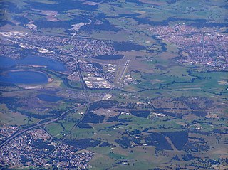
Shellharbour Airport, formerly Illawarra Regional Airport, also referred as Albion Park Aerodrome or Wollongong Airport, is an airport located in Albion Park Rail, New South Wales, Australia.

Macquarie Pass is an eight-kilometre-long section of the Illawarra Highway passing through Macquarie Pass National Park. It was opened in 1898, though had been used by the Wodi Wodi tribe.
Tongarra is a rural locality located in the Shellharbour LGA, west of Albion Park. It remains untouched from urban development. At the 2016 census, it had a population of 107.
Calderwood is a suburb in the City of Shellharbour in New South Wales, Australia, lying to the northwest of Albion Park. At the 2021 census, Calderwood had a population of 3,013. It is currently undergoing suburban redevelopment through Lendlease.
The Macquarie Valley, also known as Albion Park, Rural West or Western Valley, is an area located in the Shellharbour local government area in the Illawarra region of New South Wales, Australia.
Dunmore is a largely rural suburb of Shellharbour City in New South Wales, Australia. Dunmore is bisected north to south by the South Coast railway line and the Princes Highway.
North Macquarie is a suburb of Wollongong in the City of Shellharbour in New South Wales, Australia, 4 km west of Albion Park.

