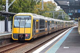
The Eastern Suburbs & Illawarra Line is a commuter railway line on the Sydney Trains network in the eastern and southern suburbs of Sydney. The line was constructed in the 1880s to Wollongong to take advantage of agricultural and mining potentials in the Illawarra area. In March 1926, it became the first railway in New South Wales to run electric train services.
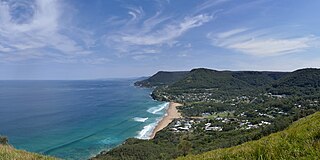
Stanwell Park is a coastal village and northern suburb of Wollongong, New South Wales, Australia. It is the northernmost point of the Illawarra coastal strip and lies south of Sydney's Royal National Park. It is situated in a small valley between Bald Hill to the north, Stanwell Tops to the west and Mount Mitchell to the south. It has two lagoons from the village's two creeks, Stanwell and Hargrave Creeks, and a beach running between headlands. Stanwell Park and the surrounding suburbs are colloquially referred to by its postcode 2508.

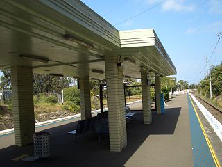
Waterfall railway station is located on the Illawarra line, serving the Sydney suburb of Waterfall. It is served by Sydney Trains' T4 Eastern Suburbs & Illawarra Line services and NSW TrainLink's South Coast Line services.

The South Coast Railway is a commuter and goods railway line from Sydney to Wollongong and Bomaderry in New South Wales, Australia. Beginning at the Illawarra Junction, the line services the Illawarra and South Coast regions of New South Wales.

The East Hills railway line serves the southern and south-western suburbs of Sydney, Australia. The line opened to East Hills in 1931 and was extended to connect to the Main South Line in 1987. Most services along the line form part of the Airport & South Line operated by Sydney Trains.

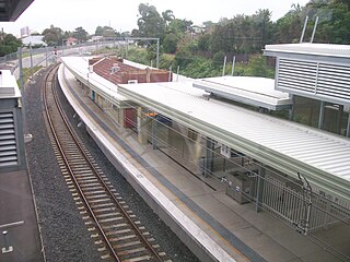
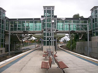
Gymea railway station is a heritage-listed railway station located on the Cronulla line, serving the Sydney suburb of Gymea. It is served by Sydney Trains' T4 Eastern Suburbs & Illawarra Line services.

Bulli railway station is a heritage-listed railway station on the South Coast railway line in New South Wales, Australia, serving the northern Wollongong suburb of Bulli. It was added to the New South Wales State Heritage Register on 30 August 2013.

Kirrawee railway station is located on the Cronulla line, serving the Sydney suburb of Kirrawee. It is served by Sydney Trains' T4 Eastern Suburbs & Illawarra Line services.
Caringbah railway station is a heritage-listed railway station located on the Cronulla line, serving the Sydney suburb of Caringbah. It is served by Sydney Trains' T4 Eastern Suburbs & Illawarra Line services.
Woolooware railway station is a heritage-listed railway station located on the Cronulla line, serving the Sydney suburb of Woolooware. It is served by Sydney Trains' T4 Eastern Suburbs & Illawarra Line services.

Scarborough railway station is a heritage-listed railway station on the South Coast railway line in New South Wales, Australia. It serves the seaside village of Scarborough. It was added to the New South Wales State Heritage Register on 2 April 1999.

Austinmer railway station is a heritage-listed railway station located on the South Coast railway line in New South Wales, Australia. It serves the northern Wollongong suburb of Austinmer. It was added to the New South Wales State Heritage Register on 2 April 1999.

Thirroul railway station is a heritage-listed railway station on the South Coast railway line in New South Wales, Australia. It serves the northern Wollongong suburb of Thirroul. It was added to the New South Wales State Heritage Register on 2 April 1999.

Coniston railway station is located in Coniston, New South Wales, Australia, on the South Coast railway line. The station serves NSW TrainLink trains travelling south to Port Kembla or Kiama and north to Wollongong and Sydney.

Cringila railway station is located in Cringila, Australia, on the South Coast railway line's Port Kembla branch. The station serves NSW TrainLink trains travelling south to Port Kembla and north to Wollongong and Sydney.
The Cronulla railway line is a suburban branch line serving the southern suburbs of Sydney, New South Wales, Australia. Sydney Trains operates electric passenger train services over the line as part of its Eastern Suburbs & Illawarra Line.
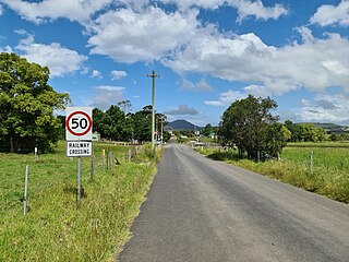
Jaspers Brush is a rural locality south of Berry, New South Wales in the City of Shoalhaven.
The Maldon – Dombarton railway line is a partially constructed railway line in New South Wales, Australia. Construction commenced in December 1983 with the project being cancelled in June 1988. A number of feasibility studies have since been conducted, but none have found the project to be viable.
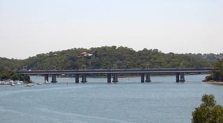
The Como railway bridge carries the Illawarra railway line across the Georges River between the Sydney suburbs of Oatley and Como.

The Stanwell Creek railway viaduct is a heritage-listed railway bridge on the Illawarra railway line at Stanwell Park, City of Wollongong, New South Wales, Australia. It was designed by the New South Wales Government Railways and built in 1920 by day labour. The property is owned by Transport Asset Holding Entity, an agency of the Government of New South Wales. It was added to the New South Wales State Heritage Register on 2 April 1999.

