Related Research Articles

Campbelltown is a suburb located on the outskirts of the metropolitan area of Sydney, New South Wales, Australia. It is located in Greater Western Sydney 53 kilometres (33 mi) south-west of the Sydney central business district by road. Campbelltown is the administrative seat of the local government area of the City of Campbelltown. It is also acknowledged on the register of the Geographical Names Board of New South Wales as one of only four cities within the Sydney metropolitan area.

Peel River, a watercourse that is part of the Namoi catchment within the Murray–Darling basin, is located in the North West Slopes and Plains district of New South Wales, Australia.

Scheyville is a suburb of Sydney, Australia. It is located 54 kilometres (34 mi) northwest of the Sydney central business district in the Hawkesbury local government area.
Gilead is a suburb of Sydney, in the state of New South Wales, Australia. Gilead is located 58 kilometres south-west of the Sydney central business district, in the local government area of the City of Campbelltown and is part of the Macarthur region.

The Upper Nepean Scheme is a series of dams and weirs in the catchments of the Cataract, Cordeaux, Avon and Nepean rivers of New South Wales, Australia. The scheme includes four dams and two weirs, and a gravity-fed canal system that feeds into a large storage reservoir to provide water to the Macarthur and Illawarra regions, the Wollondilly Shire, and metropolitan Sydney. The four dams and associated infrastructure are individually listed on the New South Wales State Heritage Register.
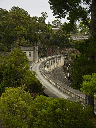
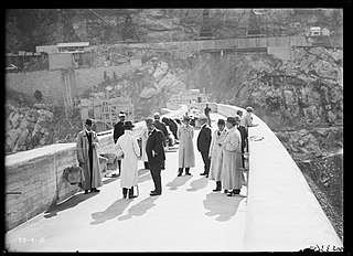
The Cordeaux Dam is a heritage-listed dam in Cordeaux, New South Wales, Australia. It provides water to the Macarthur and Illawarra regions, the Wollondilly Shire, and metropolitan Sydney. It is one of four dams and weirs in the catchment of the Upper Nepean Scheme. Completed in 1926 under the supervision of Ernest Macartney de Burgh, the dam is owned by Water NSW, an agency of the Government of New South Wales. It was listed on the New South Wales State Heritage Register on 18 November 1999.
The Nepean Dam is a heritage-listed dam split across Avon in the Wingecarribee Shire and Bargo in the Wollondilly Shire, both in New South Wales, Australia. The reservoir created by the dam spreads across Avon, Bargo and also Yerrinbool in Wingecarribee Shire. The Nepean Dam is one of four dams and weirs in the catchment of the Upper Nepean Scheme, in New South Wales, Australia, and provides water to the Macarthur and Illawarra regions, the Wollondilly Shire, and metropolitan Sydney. Completed in 1935 under the supervision of Ernest Macartney de Burgh, the dam is currently managed by the Sydney Catchment Authority and is listed on the New South Wales State Heritage Register.

The Avon Dam is a heritage-listed dam in Avon, Wingecarribee Shire, New South Wales, Australia. It is one of four dams and weirs in the catchment of the Upper Nepean Scheme, providing water to the Macarthur and Illawarra regions, the Wollondilly Shire, and metropolitan Sydney. The arch dam across the Avon River was completed in 1927 under the supervision of Ernest Macartney de Burgh, the dam is currently managed by the Sydney Catchment Authority and is listed on the New South Wales State Heritage Register.

Wollondilly Shire is a periurban local government area, located on the south west fringe of the Greater Sydney area in New South Wales, Australia, parts of which fall into the Macarthur, Blue Mountains and Central Tablelands regions in the state of New South Wales, Australia. Wollondilly is seen as the transition between Regional NSW and the Greater Sydney Region, and is variously categorised as part of both. Wollondilly Shire was created by proclamation in the NSW Government Gazette on 7 March 1906, following the passing of the Local Government (Shires) Act 1905, and amalgamated with the Municipality of Picton on 1 May 1940.

The Prospect Reservoir is a heritage-listed 50,200-megalitre potable water supply and storage reservoir created by the Prospect Dam, across the Prospect Creek located in the Western Sydney suburb of Prospect, in New South Wales, Australia. The eastern bounds of the reservoir are a recreational area and the western periphery are within the bounds of Western Sydney Parklands. It was added to the New South Wales State Heritage Register on 18 November 1999.
Burrinjuck is a village community in the far eastern part of the Riverina, in the South West Slopes. It is situated by road, about 15 kilometres (9.3 mi) southwest from Woolgarlo and 28 kilometres (17 mi) south from Bookham. The name of the town is derived from an Aboriginal word meaning 'mountain with a rugged top'. At the 2016 census, the Burrinjuck area had a population of 19.
Bong Bong was a small township in Wingecarribee Shire, New South Wales, Australia. It is also the name for the surrounding parish. It is within the Southern Highlands.
The Parish of Wilton is a parish of the County of Camden in New South Wales, Australia. It is located in the area around where Picton Road crosses the Hume Highway, and the area around nearby Wilton.
The Avon River, a perennial river of the Hawkesbury-Nepean catchment, is located in the Southern Highlands and Macarthur districts of New South Wales, Australia.
The Cordeaux River, a perennial river of the Hawkesbury-Nepean catchment, is located in the Southern Highlands and Macarthur regions of New South Wales, Australia.

The Williams River is a perennial stream that is a tributary of the Hunter River, in the Hunter Region of New South Wales, Australia.
Avon is a suburb of the City of Wollongong and Wingecarribee Shire, both in New South Wales, Australia. It is "a locality within Metropolitan Catchment Area on the western side of Illawarra Range about 4km west of Wongawilli and about 5km north west of Avondale". At the 2016 census, it had no population.
Gledswood Hills is a suburb of the Macarthur Region of Sydney in the state of New South Wales, Australia in Camden Council. The suburb name was assigned on 9 December 2011. The suburb was named after the 1830 Gledswood Homestead.

The Kiama Reservoirs are heritage-listed reservoirs at Irvine Street, Kiama, Municipality of Kiama, New South Wales, Australia. They are owned by Sydney Water. It was added to the New South Wales State Heritage Register on 15 November 2002.

St John's Roman Catholic Church and Cemetery is a heritage-listed former school and now Roman Catholic church building located in George Street in Campbelltown. It was designed by John Joseph Therry and built from 1824 to 1841. It is also known as St Johns Roman Catholic Church and Cemetery (former), Saint Johns Roman Catholic Church and Old St John's Church. It was added to the New South Wales State Heritage Register on 2 April 1999. The current church, called St John the Evangelist Catholic Church was built in 1886 and is located at Cordeaux Street, Campbelltown in the City of Campbelltown local government area of New South Wales, Australia. The property is owned by Trustees of the Roman Catholic Church for the Diocese of Wollongong.
References
- ↑ "Cordeaux". Geographical Names Register (GNR) of NSW. Geographical Names Board of New South Wales . Retrieved 12 March 2019.
- ↑ "Cordeaux Dam". New South Wales State Heritage Register . Department of Planning & Environment. H01360. Retrieved 2 June 2018.
 Text is licensed by State of New South Wales (Department of Planning and Environment) under CC-BY 4.0 licence .