
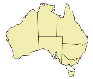
Wollongong is a city located in the Illawarra region of New South Wales, Australia. The name is believed to originate from the Dharawal language, meaning either 'five islands/clouds', 'ground near water' or 'sound of the sea'. Wollongong lies on the narrow coastal strip between the Illawarra Escarpment and the Pacific Ocean, 85 kilometres south of central Sydney. Wollongong had an estimated urban population of 302,739 at June 2018, making it the third-largest city in New South Wales after Sydney and Newcastle and the tenth-largest city in Australia by population. The city's current Lord Mayor is Tania Brown who was elected in 2024.

Arncliffe is a suburb in southern Sydney, in the state of New South Wales, Australia. Arncliffe is located 11 kilometres south of the Sydney central business district, in the local government area of the Bayside Council.

Orange is a city in the Central Tablelands region of New South Wales, Australia. It is 254 km (158 mi) west of the state capital, Sydney [206 km (128 mi) on a great circle], at an altitude of 862 metres (2,828 ft). Orange had an urban population of 41,920 at the 2021 Census, making the city a significant regional centre. A significant nearby landmark is Mount Canobolas with a peak elevation of 1,395 m (4,577 ft) AHD and commanding views of the district. Orange is situated within the traditional lands of the Wiradjuri tribe.

Fairy Meadow is a suburb in the City of Wollongong, New South Wales, Australia. Located in the Illawarra region and only 4 km from the city centre, it is a mainly low-density residential area, with a large strip of commercial and industrial properties along and off the Princes Highway.
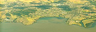
Dapto is a suburb of Wollongong in the Illawarra region of New South Wales, Australia, located on the western side of Lake Illawarra and covering 7.15 square kilometres (2.76 sq mi). As at the 2021 census, the suburb had a population of 10,954.

Mount Keira is a suburb and mountain in the Illawarra region of New South Wales, Australia.
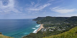
Stanwell Park is a coastal village and northern suburb of Wollongong, New South Wales, Australia. It is the northernmost point of the Illawarra coastal strip and lies south of Sydney's Royal National Park. It is situated in a small valley between Bald Hill to the north, Stanwell Tops to the west and Mount Mitchell to the south. It has two lagoons from the village's two creeks, Stanwell and Hargrave Creeks, and a beach running between headlands. Stanwell Park and the surrounding suburbs are colloquially referred to by its postcode 2508.
Unanderra is a suburb of Wollongong in New South Wales, Australia. It is located approximately 6 km south-west of the Wollongong CBD. It is bordered to the west by Farmborough, Cordeaux Heights and Farmborough Heights in the Mount Kembla foothills, the north by Figtree, the east by Berkeley and Flagstaff Hill, site of the Nan Tien Temple, and the south by Kembla Grange.

Balgownie is a small suburb of Wollongong, New South Wales, Australia.

Mount Richon is a suburb of Perth, Western Australia in the City of Armadale. Formerly part of Armadale and Wungong, Mount Richon was approved as a suburb in 2003. It occupies the western slope of the Darling Range from the intersection of Albany and South Western Highways south to Leys Rise, is bounded on the west by South-Western Highway and is bounded on the east by Albany Highway and Bungendore Park. Mount Richon is named after a vineyard that formerly existed in the area.

Frankston South is a suburb in Melbourne, Victoria, Australia, 43 km south-east of Melbourne's Central Business District, located within the City of Frankston local government area. Frankston South recorded a population of 18,801 at the 2021 census.

Woonona is a suburb north of Wollongong, New South Wales, Australia, south of Sydney. It is served by Woonona Station on the South Coast Line, and by the Princes Highway.

The Illawarra escarpment, or officially the Illawarra Range, is the fold-created cliffs and plateau-eroded outcrop mountain range west of the Illawarra coastal plain south of Sydney, in the state of New South Wales, Australia. The range encloses the Illawarra region which stretches from Stanwell Park in the north to Kiama, Gerringong and the Shoalhaven River in the south.

Coniston, is a suburb of Wollongong in New South Wales, Australia. At the 2021 census, it had a population of 2,267.

North Wollongong is a coastal suburb of the City of Wollongong, New South Wales, Australia. It is immediately to the north of the Wollongong city centre. Although North Wollongong is an official suburb with precise boundaries, the term North Wollongong may refer to northern areas of Wollongong which are not part of the suburb.
Mount Nebo, a tall hill that is part of the Illawarra Range, is located in the foothills of the Illawarra escarpment on the edge of the suburban fringe of the city of Wollongong, New South Wales, Australia. At 251 metres (823 ft) above sea level, the hill is reached by the steep O'Brien's Road from the suburb of Figtree.
Corrimal is a suburb north of the city of Wollongong, New South Wales, Australia. Corrimal's CBD is situated on the Princes Highway, and several streets adjacent to it. The main shopping centres are Lederer Corrimal and Corrimal Park Mall next to the park on the main thoroughfare of Corrimal itself. Outside this centre is an old locomotive that is affectionately known as "The Green Frog". Corrimal's welcome signs feature The Green Frog, as it ran on the Bulli Colliery Line to Bellambi Haven from 1909 to 1967. To the west is a lawn bowls club and a wealthy foothill neighbourhood of residences bordering bushland.

Figtree is an inner western suburb of Wollongong, New South Wales, Australia. It is south-west of West Wollongong and connected to Wollongong by the Princes Highway
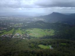
The city of Wollongong has a distinct geography. It lies on a narrow coastal plain flanked by the Pacific Ocean to the east and a steep sandstone precipice known as the Illawarra Escarpment to the west, most notably Mount Keira, joined to the escarpment by a high saddle.
