
Wollongong is a city located in the Illawarra region of New South Wales, Australia. The name is believed to originate from the Dharawal language, meaning either 'five islands/clouds', 'ground near water' or 'sound of the sea'. Wollongong lies on the narrow coastal strip between the Illawarra Escarpment and the Pacific Ocean, 85 kilometres south of central Sydney. Wollongong had an estimated urban population of 302,739 at June 2018, making it the third-largest city in New South Wales after Sydney and Newcastle and the tenth-largest city in Australia by population. The city's current Lord Mayor is Gordon Bradbery AM who was elected in 2021.

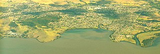
Lake Illawarra is an open and trained intermediate wave dominated barrier estuary or large coastal lagoon, is located in the Illawarra region of New South Wales, situated about 100 kilometres (62 mi) south of Sydney, Australia.
Dapto is a suburb of Wollongong in the Illawarra region of New South Wales, Australia, located on the western side of Lake Illawarra and covering 7.15 square kilometres (2.76 sq mi). As at the 2021 census, the suburb had a population of 10,954.

Narrabeen is a beachside suburb of northern Sydney, New South Wales, Australia, 23 kilometres northeast of the business district, shared by the local government area of Northern Beaches Council and the Northern Beaches region. The bay was named Broken Bay by James Cook as he sailed past.
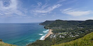
Stanwell Park is a coastal village and northern suburb of Wollongong, New South Wales, Australia. It is the northernmost point of the Illawarra coastal strip and lies south of Sydney's Royal National Park. It is situated in a small valley between Bald Hill to the north, Stanwell Tops to the west and Mount Mitchell to the south. It has two lagoons from the village's two creeks, Stanwell and Hargrave Creeks and a beach running between headlands. Stanwell Park and the surrounding suburbs are colloquially referred to by its postcode 2508.

Yarrawarrah is a suburb in southern Sydney, in the state of New South Wales, Australia 32 kilometres south of the Sydney central business district, in the local government area of the Sutherland Shire.

Allawah is a suburb in southern Sydney, in the state of New South Wales, Australia. Allawah is 16 kilometres south of the Sydney central business district and is part of the St George area. Allawah lies in the local government area of the Georges River Council. The postcode is 2218, which is shared by the neighbouring suburb of Carlton.

Cardiff is a small town in the Lake Macquarie LGA of New South Wales, Australia.

Eschol Park is a suburb of Sydney, in the state of New South Wales, Australia. Eschol Park is located 60 kilometres south-west of the Sydney central business district, in the local government area of the City of Campbelltown and is part of the Macarthur region.

Windang is a suburb of Wollongong in New South Wales on the southern tip of the peninsula guarding the ocean entrance to Lake Illawarra. Windang is popular for its fishing, prawning, boating, windsurfing and yachting. Windang is about 98 km south of Sydney, approximately 20 minutes drive south of the Wollongong CBD and about seven minutes from Shellharbour.

Oak Flats is a suburb of Shellharbour, New South Wales, Australia situated on the south western shores of Lake Illawarra and within the Illawarra region of New South Wales. It is a residential area, which had a population of 6,840 at the 2021 census.

Warrawong is a suburb of Wollongong in the Illawarra region of New South Wales, Australia. It is situated on the northeast corner of Lake Illawarra.

Bellambi is a suburb of Wollongong in the Illawarra region of New South Wales, Australia. It has a railway station on the NSW TrainLink South Coast Line.
Wyee is a small town in Greater Newcastle that is located in the City of Lake Macquarie local government area in the Hunter region of New South Wales, Australia. The town is near the Pacific Motorway and has a railway station which opened in 1892 that is on NSW TrainLink's Central Coast & Newcastle Line which is part of the Main Northern NSW line. It had a population of 1,487 in 2001, which significantly increased to 2,588 in 2011, and decreased to 2,406 in 2016.
Garden Suburb is a small semi-rural community in the City of Lake Macquarie local government area in the Greater Newcastle area in the state of New South Wales, Australia. It is located 2 kilometres East of Cardiff.
South Durras is a small village on the South Coast of New South Wales, Australia. South Durras is located approximately 280 kilometres south of Sydney and 15 kilometres north of Batemans Bay, in the local government area of Eurobodalla Shire. The village is surrounded by the Murramarang National Park.

Marshall Mount is a suburb of Wollongong in New South Wales, Australia. It is located between the larger centres of Dapto and Albion Park.
Kanahooka is a southern suburb in Wollongong City Council. It has a few shops and a playground. Situated on Lake Illawarra is a Park with a playground. It has a public school and a high school.
Yallah is a western suburb in the City of Wollongong, New South Wales, Australia, located on the western shore of Lake Illawarra. It contains a mixture of rural, commercial and light industrial areas.

Toongabbie Creek, an urban watercourse that is part of the Parramatta River catchment, is located in Greater Western Sydney, New South Wales, Australia.
