Shellharbour is a suburb located in the Illawarra region of New South Wales, Australia. It also gives its name to the local government area, City of Shellharbour, and its central business district, Shellharbour City Centre.
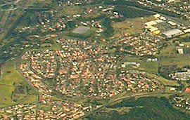
Albion Park is a suburb situated in the Macquarie Valley in the City of Shellharbour, which is in turn one of the three local government areas that comprise the Wollongong Metropolitan Area, New South Wales, Australia. Although it is surrounded by a 'green belt' of farms, Albion Park had a population of 13,316 at the 2016 census.
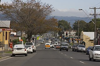
Albion Park Rail is a suburb of Shellharbour, Australia situated in the Macquarie Valley (Shellharbour). The South Coast railway line was opened to the railway station and Bombo in 1887. At the time the nearest town was Albion Park, several kilometres away. Over time, houses were built around the railway station, and Albion Park Rail developed into a town in its own right, and with its own name.

Warilla is a seaside suburb of the City of Shellharbour, Australia within the Wollongong urban area. It is one of the more established areas and is between the suburbs of Mount Warrigal in the west, Barrack Heights and Barrack Point in the south and Lake Illawarra in the north.
New Lambton is a suburb of Newcastle, in the Hunter Region of New South Wales, Australia. It is located about 6 km (4 mi) west of the Newcastle central business district. It includes two shopping districts, schools and other general facilities. At the 2016 Australian census it had a population of approximately 10,000.
Warilla High School is a government-funded co-educational comprehensive secondary day school, located in Barrack Heights, a suburb of the City of Shellharbour, in the Illawarra region of New South Wales, Australia.

The City of Shellharbour is a local government area in the Illawarra region of New South Wales, Australia. The city is located about 100 kilometres (62 mi) south of Sydney and covers the southern suburbs of the Wollongong urban area centred on Shellharbour and it had an estimated population of 68,460 at the 2016 census.

Oak Flats is a suburb of Shellharbour, New South Wales, Australia situated on the south western shores of Lake Illawarra and within the Illawarra region of New South Wales. It is a residential area, which had a population of 6,415 at the 2016 census.
Shellharbour is an electoral district of the Legislative Assembly in the Australian state of New South Wales. It is represented by Anna Watson who won Labor preselection after the former member Lylea McMahon decided not to contest the 2011 election.

Barrack Heights is a suburb of the City of Shellharbour in New South Wales, Australia in the local government area of the same name. Many institutions are located in Barrack Heights, including Shellharbour Public Hospital, Shellharbour Private Hospital, Warilla Bowling Club, Warilla Sports Club and Warilla High School.

Mount Warrigal is a large suburb of Shellharbour, New South Wales, Australia. The population, according to the 2016 Australian Census, was 4,909. The suburb is in the Shellharbour City LGA.

Shellharbour City Centre is the central business district of the City of Shellharbour, located in the Illawarra region of New South Wales, Australia. Its name reflects its status as the commercial and administrative centre for the City of Shellharbour local government area, and is home to the Council Administration Centre, Stockland Shellharbour shopping centre, cinemas and other retail shops. In recent years, apartment buildings have become more common within the district.
Shell Cove is a seaside suburb in the Shellharbour area located just south of Wollongong, New South Wales, Australia. Shell Cove adjoins Bass Point and Killalea State Park and includes a variety of facilities and amenities such as: parks and bush reserves, The Links Golf Course, Shell Cove Public School & pre-schools, Shellharbour Anglican College, Family Health Medical Centre and of course The newly developed Shell Cove Marina.

Flinders is a southern suburb of Shellharbour, located in the Illawarra region of New South Wales, Australia. Flinders is located approximately 111 kilometres south-southwest of New South Wales' capital city of Sydney. Flinders is close to a number of beaches and to and over 60 hectares of green open spaces including bush reserves, waterways and landscaped parks. Flinders adjoins neighbouring suburbs of Shellharbour, Shell Cove, Blackbutt and Shell Heights.
Tullimbar is a suburb situated in the Macquarie Valley in the City of Shellharbour, New South Wales, Australia.
Croom is a rural locality of Wollongong in New South Wales, Australia, part of the state suburb of Dunmore. The name has been variously spelled Croomb, Croom and Croome. The locality shares its name with the village of Croom in County Limerick, Ireland – derived from the Irish cromadh, meaning bend.
Barrack Point is a seaside suburb of the City of Shellharbour, New South Wales, Australia which sits within the southern Wollongong urban area. Surrounding suburbs are Warilla to the north, Barrack Heights to the west, and Shellharbour to the south.

Dunmore is a largely rural suburb of Shellharbour City in New South Wales, Australia. Dunmore is bisected north to south by the South Coast railway line and the Princes Highway.
North Macquarie is a suburb of Wollongong in the City of Shellharbour in New South Wales, Australia, 4 km west of Albion Park.