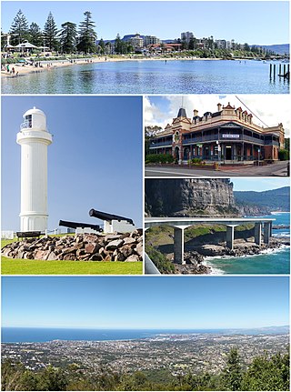
Wollongong, colloquially referred to as The Gong, is a city located in the Illawarra region of New South Wales, Australia. The name is believed to originate from the Dharawal language, meaning either 'five islands/clouds', 'ground near water' or 'sound of the sea'. Wollongong lies on the narrow coastal strip between the Illawarra Escarpment and the Pacific Ocean, 85 kilometres south of central Sydney. Wollongong had an estimated urban population of 302,739 at June 2018, making it the third-largest city in New South Wales after Sydney and Newcastle and the tenth-largest city in Australia by population. The city's current Lord Mayor is Gordon Bradbery AM who was elected in 2021.
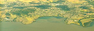
Dapto is a suburb of Wollongong in the Illawarra region of New South Wales, Australia, located on the western side of Lake Illawarra and covering an area 7.15 square kilometres in size. As at the 2016 census, the suburb had a population of 10,730.
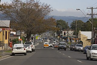
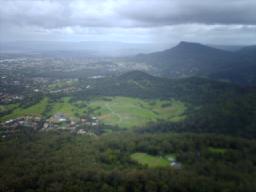
Unanderra is a suburb of Wollongong in New South Wales, Australia. It is located approximately 6 km south-west of the Wollongong CBD. It is bordered to the west by Farmborough, Cordeaux Heights and Farmborough Heights in the Mount Kembla foothills, the north by Figtree, the east by Berkeley and Flagstaff Hill, site of the Nan Tien Temple, and the south by Kembla Grange.
Albion Park is a suburb situated in the Macquarie Valley in the City of Shellharbour, which is in turn one of the three local government areas that comprise the Wollongong Metropolitan Area, New South Wales, Australia. Although it is surrounded by a 'green belt' of farms, Albion Park had a population of 13,316 at the 2016 census.
Mount Pleasant is a hilly suburb in the city of Wollongong, New South Wales, Australia. It is situated on the northern flank of Mount Keira extending across to the Illawarra escarpment and is exclusively residential. It is home to the Rhododendron Park, found on Parrish Avenue. Mount Pleasant has a small local primary school Pleasant Heights Public School which has approximately 180 enrolled students. The suburb is locally notable for its commonly known Brokers Road which is amongst the steepest roads in New South Wales.
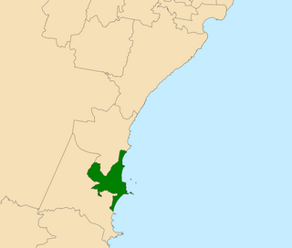
Wollongong is an electoral district of the Legislative Assembly in the Australian state of New South Wales. It is represented by Paul Scully of the Labor Party. Since a redistribution in 2013, it has covered an area of 79.25 square kilometres and includes the localities of Berkeley, Coachwood Park, Coniston, Cordeaux Heights, Corrimal, Cringila, Fairy Meadow, Farmborough Chase, Farmborough Heights, Figtree, Gwynneville, Kembla Grange, Kembla Heights, Kemblawarra, Lake Heights, Lindsay Heights, Mangerton, Mount Kembla, Mount Saint Thomas, North Wollongong, Port Kembla, Primbee, Spring Hill, Towradgi, Unanderra, Warrawong, West Wollongong, Windang, Wollongong.

The City of Shellharbour is a local government area in the Illawarra region of New South Wales, Australia. The city is located about 100 kilometres (62 mi) south of Sydney and covers the southern suburbs of the Wollongong urban area centred on Shellharbour and it had an estimated population of 68,460 at the 2016 census.

Coniston, is a suburb of Wollongong in New South Wales. At the 2016 census, it had a population of 2,268.

North Wollongong is a coastal suburb of the City of Wollongong, New South Wales, Australia. It is immediately to the north of the Wollongong city centre. Although North Wollongong is an official suburb with precise boundaries, the term North Wollongong may refer to northern areas of Wollongong which are not part of the suburb.
Mount Nebo, a tall hill that is part of the Illawarra Range, is located in the foothills of the Illawarra escarpment on the edge of the suburban fringe of the city of Wollongong, New South Wales, Australia. At 251 metres (823 ft) above sea level, the hill is reached by the steep O'Brien's Road from the suburb of Figtree.

Keiraville is an inner suburb of the city of Wollongong, New South Wales, Australia in the Illawarra region. It is situated in the foothills of Mount Keira, approximately three kilometres northwest of Wollongong.
Mangerton is an inner western suburb of the coastal city of Wollongong, New South Wales, Australia.

Mount Ousley is a residential suburb situated on the foothills of Mount Keira about four kilometres northwest from the city of Wollongong, New South Wales, Australia. It is also the name of the road which crosses the nearby Illawarra Escarpment and is adjacent to the University of Wollongong. Mount Ousley has a public school, Mount Ousley Public School.
West Wollongong is the innermost western suburb of the coastal city of Wollongong, New South Wales, Australia. It is mainly a residential area, serviced by a small commercial strip with a music store, chicken shop, electric goods store and carpet store along the Princes Highway with several petrol stations, two restaurants, a liquor store, a chemist and a flower shop.

Drummond Battery, also known as Fort Drummond, is a heritage-listed former coastal artillery fortification and now television station and mushroom farm at 1 Television Avenue, Mt Drummond, Mount Saint Thomas, City of Wollongong, New South Wales, Australia. It was built between 1942 and 1943 by the NSW Public Works Department and NSW Department of Main Roads. The Australian Army used the site from 1942.

Marshall Mount is a suburb of Wollongong in New South Wales, Australia. It is located between the larger centres of Dapto and Albion Park.

The Cordeaux River, a perennial river of the Hawkesbury-Nepean catchment, is located in the Southern Highlands and Macarthur regions of New South Wales, Australia.
Cleveland is a suburb of the City of Wollongong to the west of Dapto. At the 2016 census, it had a population of 21.
Huntley is a suburb of the City of Wollongong to the west of Dapto. At the 2016 census, it had a population of 50.
Haywards Bay is a suburb of the City of Wollongong to the south of Dapto. At the 2021 census, it had a population of 1,280.
