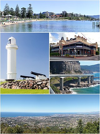
Wollongong, colloquially referred to as The Gong, is a city located in the Illawarra region of New South Wales, Australia. The name is believed to originate from the Dharawal language, meaning either 'five islands/clouds', 'ground near water' or 'sound of the sea'. Wollongong lies on the narrow coastal strip between the Illawarra Escarpment and the Pacific Ocean, 85 kilometres south of central Sydney. Wollongong had an estimated urban population of 302,739 at June 2018, making it the third-largest city in New South Wales after Sydney and Newcastle and the tenth-largest city in Australia by population. The city's current Lord Mayor is Gordon Bradbery AM who was elected in 2021.

Waterfall is a small suburb in southern Sydney, in the state of New South Wales, Australia. It is 40 kilometres south of the Sydney central business district in the Sutherland Shire. It is the southernmost suburb of Sydney in the eastern corridor, bordering the Illawarra region.

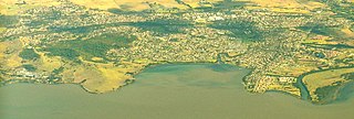
Lake Illawarra, is an open and trained intermediate wave dominated barrier estuary or large coastal lagoon, is located in the Illawarra region of New South Wales, situated about 100 kilometres (62 mi) south of Sydney, Australia.
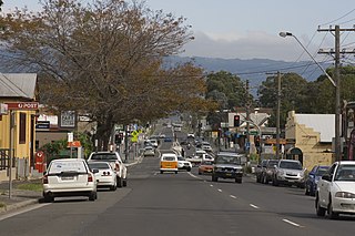
Dapto is a suburb of Wollongong in the Illawarra region of New South Wales, Australia, located on the western side of Lake Illawarra and covering 7.15 square kilometres (2.76 sq mi). As at the 2016 census, the suburb had a population of 10,730.
Albion Park is a suburb situated in the Macquarie Valley in the City of Shellharbour, which is in turn one of the three local government areas that comprise the Wollongong Metropolitan Area, New South Wales, Australia. Although it is surrounded by a 'green belt' of farms, Albion Park had a population of 13,316 at the 2016 census.

The South Coast Line is an intercity rail service operated by NSW TrainLink that services the Illawarra region of New South Wales, Australia. The service runs from Central, and runs the entire length of the eponymous South Coast railway line to Bomaderry. The service also runs along the Eastern Suburbs railway line at peak hours and the Port Kembla railway line to Port Kembla. It is operated with NSW TrainLink H sets and Sydney Trains T sets, with Endeavour railcars operating the service on the non-electrified line between Kiama and Bomaderry.

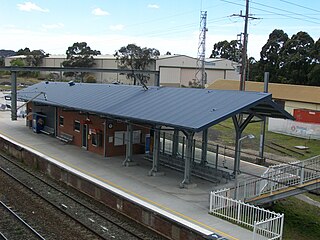
Dapto railway station is located on the South Coast railway line in the Wollongong suburb of Dapto, New South Wales, Australia.
Unanderra railway station is located on the South Coast railway line in the Wollongong suburb of Unanderra, New South Wales, Australia.

The City of Shellharbour is a local government area in the Illawarra region of New South Wales, Australia. The city is located about 100 kilometres (62 mi) south of Sydney and covers the southern suburbs of the Wollongong urban area centred on Shellharbour and it had an estimated population of 68,460 at the 2016 census.

The Illawarra Rugby League is a rugby league competition in Wollongong, NSW. It is one of the oldest rugby league competitions in Australia, founded in 1911 with five clubs. The area provides a nursery of juniors for the Illawarra Steelers and St George Illawarra Dragons. The season is contested by seven teams and concludes with a finals series involving the top four teams.

Kanahooka High School is a government-funded co-educational comprehensive secondary day school, located in Kanahooka, 15 kilometres (9 mi) southwest of the city of Wollongong, in the Illawarra region of New South Wales, Australia.

Dapto High School is a government-funded co-educational comprehensive secondary day school, located in Dapto, a suburb of Wollongong in the Illawarra region of New South Wales, Australia.

Figtree High School is a government-funded co-educational comprehensive secondary day school, located on Gibsons Road in Figtree, a suburb of Wollongong, in the Illawarra region of New South Wales, Australia.

Marshall Mount is a suburb of Wollongong in New South Wales, Australia. It is located between the larger centres of Dapto and Albion Park.
Kanahooka is a southern suburb in Wollongong City Council. It has a few shops and a playground. Situated on Lake Illawarra is a Park with a playground. It has a public school and a high school.
Cleveland is a suburb of the City of Wollongong to the west of Dapto. At the 2016 census, it had a population of 21.
Huntley is a suburb of the City of Wollongong to the west of Dapto. At the 2016 census, it had a population of 50.
Haywards Bay is a suburb of the City of Wollongong to the south of Dapto. At the 2021 census, it had a population of 1,280.
Dombarton is a rural locality north west of Dapto in the Wollongong LGA, in the Illawarra region of New South Wales, Australia, located on the western side of Lake Illawarra. It is also known for the uncompleted Maldon – Dombarton railway line.
