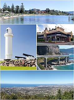
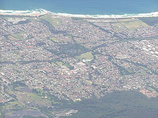
Wollongong, informally referred to as "The Gong", is a city located in the Illawarra region of New South Wales, Australia. The name is thought to be derived from the word woolyungah in the language of the Aboriginal inhabitants at the time of settlement, meaning five islands. Wollongong lies on the narrow coastal strip between the Illawarra Escarpment and the Pacific Ocean, 85 kilometres south of central Sydney. Wollongong had an estimated urban population of 302,739 at June 2018, making it the third-largest city in New South Wales after Sydney and Newcastle and the tenth-largest city in Australia by population. The city's current Lord Mayor is Gordon Bradbery AM who was elected in 2021.

Bulli is a northern suburb of Wollongong situated on the south coast of New South Wales, Australia.
Robertson is a town in the Southern Highlands of New South Wales, Australia, in Wingecarribee Shire. The town is located on the edge of an elevated plateau about 35 km (22 mi) from the coast.

Mount Keira is a suburb and mountain in the Illawarra region of New South Wales, Australia.
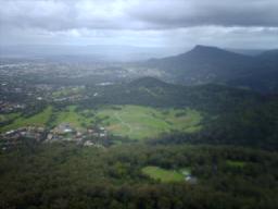
Mount Kembla is a suburb and a mountain in the Illawarra region of New South Wales, Australia.

Towradgi is a small beach-side suburb approximately 5 km (3.1 mi) north of Wollongong, New South Wales, Australia. Towradgi is derived from the Dharawal word Kow-radgi, meaning "guardian of the sacred stones". On an early map it was called Towroger. Towradgi is served by electric trains at Towradgi railway station, opened in 1948.

Thirroul is a northern seaside suburb of the city of Wollongong, Australia. Situated between Austinmer and Bulli, it is approximately 13 kilometres north of Wollongong, and 73 km south of Sydney. It lies between the Pacific Ocean and a section of the Illawarra escarpment known as Lady Fuller Park, adjacent to Bulli Pass Scenic Reserve.

The South Coast Railway is a commuter and goods railway line from Sydney to Wollongong and Bomaderry in New South Wales, Australia. Beginning at the Illawarra Junction, the line services the Illawarra and South Coast regions of New South Wales.

Otford is a village in the Otford Valley just 55 km to the south of the Sydney metropolitan area and north of the Illawarra and Wollongong in New South Wales, Australia. Otford is within the local government area of Wollongong City Council.

Helensburgh railway station is a heritage-listed railway station located on the South Coast railway line in New South Wales, Australia. It serves the town of Helensburgh. It was added to the New South Wales State Heritage Register on 2 April 1999.

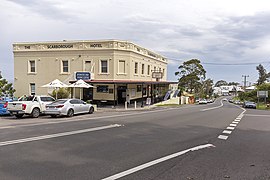
Scarborough railway station is a heritage-listed railway station on the South Coast railway line in New South Wales, Australia. It serves the seaside village of Scarborough. It was added to the New South Wales State Heritage Register on 2 April 1999.

Coalcliff is a town on the coast of New South Wales, Australia, between Sydney and Wollongong.

Helensburgh, New South Wales, Australia is a small town, located 45 kilometres south of the Sydney central business district and 35 kilometres (22 mi) north of Wollongong and north and above the Illawarra escarpment and region. Helensburgh is in the Wollongong City Council local government area. It is surrounded by bushland reserves being adjacent to the southern end of the Royal National Park and Garawarra State Conservation Area and the Woronora reservoir water catchment is to its west.

Clifton is a village on the coast of New South Wales, Australia, between Sydney and Wollongong. Along with nearby Coalcliff, the village began life as a coal-mining centre. It is situated on a narrow area between the sea and the Illawarra escarpment. The electrified South Coast railway line passes through, but the station at Clifton was closed in 1915. It reopened on 1934-07-04 and closed for the last time on 1983-11-27, at the time of double tracking and electrification.

Austinmer is a northern village of Wollongong on the south coast of New South Wales, Australia. It sits in the northern Illawarra region, south of Stanwell Park and immediately north of Thirroul.
Corrimal is a northern suburb of the city of Wollongong, New South Wales, Australia. Corrimal's CBD is situated on the Princes Highway, and several streets adjacent to it. The main shopping centres are Lederer Corrimal and Corrimal Park Mall next to the park on the main thoroughfare of Corrimal itself. Outside this centre is an old locomotive that is affectionately known as "The Green Frog". Corrimal's welcome signs feature The Green Frog, as it ran on the Bulli Colliery Line to Bellambi Haven from 1909 to 1967. To the west is a lawn bowls club and a wealthy foothill neighbourhood of residences bordering bushland.

Bellambi is a suburb of Wollongong in the Illawarra region of New South Wales, Australia. It has a railway station on the NSW TrainLink South Coast Line.
Kembla Heights is a village west of Wollongong, New South Wales in the Parish of Kembla County of Camden. It is situated along Harry Graham Drive and upper Cordeaux Road and is part of a tourist route that runs along the Illawarra escarpment for a distance between Mount Kembla and Mount Keira. The Dendrobium Colliery is located in Kembla Heights.

Wongawilli is a southern suburb of Wollongong, Australia at the foot hills of the Illawarra escarpment. The word 'Wonga' is a native aboriginal word meaning native pigeon.

The Helensburgh Glow Worm tunnel is a disused rail tunnel in Helensburgh, New South Wales that has become a popular tourist attraction due to its haunted history, and most notably, its glow worm population. It is owned by Crown Lands and managed by a community group Helensburgh Landcare who, in early 2019, restricted access to the tunnel for the conservation of the glow worm colony. As of 9 February 2020, the tunnel was closed for an indefinite period due to excessive flooding and to help the glow worm population recover.