Illawarra

Last updated

Illawarra
New South Wales
Sunset lake illawarra.jpg
Sunset over Lake Illawarra
Australia New South Wales relief location map.png
Red pog.svg
Illawarra
Coordinates 34°30′S150°54′E / 34.5°S 150.9°E / -34.5; 150.9
Population313,842 (2021) [1]
 • Density288.19/km2 (746.4/sq mi)
Area1,089 km2 (420.5 sq mi)
Time zone AEST (UTC+10)
 • Summer (DST) AEDT (UTC+11)
Location85 km (53 mi) S of Sydney
LGA(s)
State electorate(s)
Federal division(s)
Localities around Illawarra:
Macarthur (Greater Sydney) Southern Sydney (Greater Sydney) Tasman Sea
Southern Highlands Illawarra Tasman Sea
Southern Tablelands South Coast Tasman Sea

The Illawarra is a coastal region in the southeast of the Australian state of New South Wales. It is situated immediately south of Sydney and north of the South Coast region. It encompasses the two cities of Wollongong, Shellharbour and the coastal town of Kiama. Wollongong is the largest city of the Illawarra with a population of 240,000, then Shellharbour with a population of 70,000 and Kiama with a population of 10,000. These three cities have their own suburbs. Wollongong stretches from Otford in the north to Windang in the south, with Maddens Plains and Cordeaux in the west.

Contents

The Illawarra region is characterised by three distinct districts: the north-central district, which is a contiguous urban sprawl centred on Lake Illawarra, the western district defined by the Illawarra escarpment, which leads up to the fringe of Greater Metropolitan Sydney including the Macarthur in the northwest, and to the Southern Highlands region in the southwest, which is historically semi-rural, but now defined by increasing urbanisation.

Etymology

The word "illawarra" is derived from the Aboriginal Tharawal word "allowrie," also sometimes spelled as "elouera" or "eloura." According to A. W. Reed, the word is variously translated as "pleasant place near the sea" or "high place near the sea." [2] [3] The prefix of "illa" is also known to mean "white clay;" with the suffix "warra," sometimes spelled as "wurra," meaning "mountain" in the local indigenous language. [3] George Bass and Matthew Flinders were the first Europeans to visit the area, with Flinders recording that it 'was called "Allowrie" by the natives'. [2]

For the period around 1806, the region was called "Five Islands"; referring to the group of five islands off Red Point. [2] [4] [ failed verification ] In 1817 Governor Macquarie, referring to region, wrote: 'part of the coast known generally by the name of the Five Islands, but called by the natives "Illawarra". [2]

History

Geography

Lookout from the Illawarra escarpment above Wombarra over the northern Illawarra plain viewing Austinmer, Thirroul, Bulli, Wollongong up to Port Kembla in the far. Subpointlookout.jpg
Lookout from the Illawarra escarpment above Wombarra over the northern Illawarra plain viewing Austinmer, Thirroul, Bulli, Wollongong up to Port Kembla in the far.
Illawarra Escarpment above Austinmer, showing Hawkesbury sandstone, Rainforest and Eucalyptus forest. Illawarra Escarpment.jpg
Illawarra Escarpment above Austinmer, showing Hawkesbury sandstone, Rainforest and Eucalyptus forest.
A section of the Illawarra coastline, c. 1900 A bit of the Illawarra Coast from The Powerhouse Museum.jpg
A section of the Illawarra coastline, c.1900

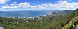
The region consists of a grassy coastal plain, narrow in the north and wider in the south, bounded by the Tasman Sea on the east and the mountainous, almost impassable Illawarra escarpment (forming the eastern edge of the Southern Highlands plateau) to the west. In the middle of the region is Lake Illawarra, a shallow lake formed when sediment built up at the entrance to a bay. The district extends from the southern hills of the Royal National Park in the north to the Shoalhaven River in the south, and contains the city of Wollongong, the fourth largest urban area in New South Wales.

North of Wollongong the plain narrows to a small strip of land between the coast and the escarpment. At Coalcliff and Stanwell Park small valleys are formed allowing further settlement. To the south it widens, and becomes increasingly hillier before reaching Stockyard Mountain, a long divide between the main plain and the Jamberoo Valley, which stretches until it reaches Kiama. South of Kiama is Saddleback Mountain and south of that the Shoalhaven plains and the outcrop of Coolangatta Mountain.

Ecology

Illawarra Sunset SunsetNSW.jpg
Illawarra Sunset

Ecologically, the coastal grassy region of the Illawarra is within the Illawarra Lowlands Grassy Woodland biome. Characteristic tree species in the region include Eucalyptus tereticornis , Eucalyptus eugenioides , Eucalyptus longifolia , Eucalyptus bosistoana and Melaleuca decora . Shrub species include Acacia mearnsii , Dodonaea viscosa and as well as the endangered orchard Pterostylis gibbosa . [5]

The wet elevated areas of the Illawarra, where rainfall exceeds 1300mm, are within the Southern Lowland Wet Sclerophyll Forests and Southern Escarpment Wet Sclerophyll Forests biomes which generally feature tall, compact eucalyptus forests 30m-60m tall and understorey that include moist shrubs, tree ferns, a few vines and a uninterrupted herbaceous groundcover. [6] [7] The Illawarra-Shoalhaven subtropical rainforest lies in the region.

Government administration

For the purposes of Australian federal elections for the House of Representatives, the Illawarra region is contained within the electoral Divisions of Cunningham, Whitlam and the northern tip of Gilmore. [8] [9] [10]

For the purposes of New South Wales elections for the NSW Legislative Assembly, the Illawarra region is contained within the electoral districts of Wollongong, Keira, Shellharbour, Heathcote, and Kiama.

For the purposes of local government administration, the Illawarra region is contained within the cities of Wollongong, Shellharbour and the Municipality of Kiama.

Economy

The main industries in the area have traditionally been farming, coal mining and steel making. Australia's largest steel-works, BlueScope, operates at Port Kembla. The area, especially around Port Kembla and Wollongong, was once known for its mainly industrial jobs, but since the 1990s commerce has played an increasing role in the city, overtaking industry in many areas.

Illawarra cattle were originally bred in Illawarra and are now Australia's 3rd largest breed in population. They are large dark red cows sometimes with white patches. They produce large amounts of high butter fat and high protein milk and are suited to the Australian climate. [11] The Illawarra Central Co-operative Dairy Factory was used by the Illawarra Central Co-operative Dairy Co. Ltd. for the intake of milk and cream from dairy farmers in the local area.

Coal mining has been a key part to the Illawarra's economy for over 200 years. [12] The southern part of the region has been a source of crushed-stone construction aggregate and railway track ballast material for over 140 years. [13]

Transport

The Illawarra region is linked to Sydney in the north by several passes, a motorway (Southern Freeway) and an electric railway (see Illawarra railway line); to the west by the Illawarra Highway and Picton Road; and to the south by the Princes Highway. At Albion Park Rail the Illawarra Regional Airport serves the region. [14]

Sport

Rugby League Football

The Illawarra Steelers Rugby league Football Club played in the NSWRL rugby league competition, then the NRL, from 1982 to 1998, and currently forms one half of the St George Illawarra Dragons joint venture, who play six of their twelve home games at WIN Stadium in Wollongong. The Illawarra Steelers still field teams in the lower rugby league divisions.

Many famous footballers, such as Bob Fulton, Graeme Langlands, Mick Cronin, Rod Wishart, Paul McGregor, Craig Fitzgibbon, Luke Bailey, Steve Roach, Garry Jack, Warren Ryan, and the Stewart brothers Brett and Glenn, have come from the Illawarra region.

Basketball

The Illawarra Hawks have represented the region (previously known as The Hawks and the Wollongong Hawks) since the foundation year of the NBL, 1979. They won the NBL championship in 2001 defeating the Townsville Crocs 2-1 in the best of 3 finals. They also finished as runners-up in 2005 and 2010 seasons. The team caught global attention when American teen sensation LaMelo Ball announced on ESPN's show The Jump that he will be joining the Hawks through the NBL's Next Star program. In April 2020, LaMelo Ball and his business manager, Jermaine Jackson announced they had bought the Hawks. [15]

Association football

The Wollongong Wolves participated in the now defunct NSL, winning back to back premierships in 2000 and 2001. The Wolves were not selected for the NSL's replacement, the A-League, and instead chose to compete in the New South Wales Premier League under the name Wollongong FC. The Wolves organisation collapsed in 2008, and was taken over by Wollongong Community Football Club. The Wolves have continued to play in the New South Wales Premier League.

Cricket

Cricket has also been played in the Illawarra for at least one hundred and fifty years with the Keira Cricket Club being founded in 1862.

Water Polo

The first recorded match of water polo in the Illawarra came in 1894, in a men's match between the Wollongong and Kiama Swim Clubs at Brighton Beach. The Kiama Swim Club prevailed, winning 3-0. [16] Water polo is currently played at UOW Pool through the Illawarra Water Polo Club. Each year, Illawarra also compete at the NSW Country Club Championships, whereby the Illawarra U14's boys won in 2021. [17]

See also

Related Research Articles

<span class="mw-page-title-main">Wollongong</span> City in New South Wales, Australia

Wollongong, colloquially referred to as The Gong, is a city located in the Illawarra region of New South Wales, Australia. The name is believed to originate from the Dharawal language, meaning either 'five islands/clouds', 'ground near water' or 'sound of the sea'. Wollongong lies on the narrow coastal strip between the Illawarra Escarpment and the Pacific Ocean, 85 kilometres south of central Sydney. Wollongong had an estimated urban population of 302,739 at June 2018, making it the third-largest city in New South Wales after Sydney and Newcastle and the tenth-largest city in Australia by population. The city's current Lord Mayor is Gordon Bradbery AM who was elected in 2021.

<span class="mw-page-title-main">Kiama, New South Wales</span> Town in New South Wales, Australia

Kiama is a coastal country town 120 kilometres south of Sydney in the Illawarra. One of the main tourist attractions is the Kiama Blowhole. Kiama features several popular surfing beaches and caravan parks, and numerous alfresco cafes and restaurants. Its proximity to the south of Sydney makes it an attractive destination for many day-trippers and weekenders. Kiama also has historically been a farming and agricultural centre. Even to today it maintains a country and agricultural community with a weekly farmers markets held on Wednesday afternoons.

<span class="mw-page-title-main">Gerringong, New South Wales</span> Town in New South Wales, Australia

Gerringong is a town located about ten minutes drive south of Kiama, and about twenty minutes north of Nowra in the Illawarra region of New South Wales, Australia in the Municipality of Kiama. At the 2016 census, Gerringong had a population of 3,966. One theory says that the name derives from an Aboriginal word meaning "fearful place".

<span class="mw-page-title-main">Oak Flats railway station</span> Railway station in New South Wales, Australia

Oak Flats railway station is a single-platform intercity train station located in Oak Flats, New South Wales, Australia, on the South Coast railway line. The station serves NSW TrainLink trains travelling south to Kiama and north to Wollongong and Sydney. Together with the Dunmore and later Shellharbour Junction stations, Oak Flats has long served as the rail connection for the coastal suburbs of the City of Shellharbour.

<span class="mw-page-title-main">Dapto railway station</span> Railway station in New South Wales, Australia

Dapto railway station is located on the South Coast railway line in the Wollongong suburb of Dapto, New South Wales, Australia.

<span class="mw-page-title-main">Unanderra railway station</span> Railway station in New South Wales, Australia

Unanderra railway station is located on the South Coast railway line in the Wollongong suburb of Unanderra, New South Wales, Australia.

<span class="mw-page-title-main">Illawarra escarpment</span> Mountain range in New South Wales, Australia

The Illawarra escarpment, or officially the Illawarra Range, is the fold-created cliffs and plateau-eroded outcrop mountain range west of the Illawarra coastal plain south of Sydney, in the state of New South Wales, Australia. The range encloses the Illawarra region which stretches from Stanwell Park in the north to Kiama, Gerringong and the Shoalhaven River in the south.

<span class="mw-page-title-main">Electoral district of Kiama</span> State electoral district of New South Wales, Australia

Kiama is an electoral district of the Legislative Assembly in the Australian state of New South Wales. It is currently represented by Gareth Ward. Originally elected as a member of the Liberal Party, Ward stood down from the party in May 2021 following allegations of sexual misconduct.

<span class="mw-page-title-main">Illawarra Steam Navigation Company</span> Australian steamship company

The Illawarra Steam Navigation Company was a shipping company that serviced the south coast of New South Wales, Australia from 1858 to the early 1950s. It was formed through the amalgamation of the General Steam Navigation Company, the Kiama Steam Navigation Company and the Shoalhaven Steam Navigation Company, each of whom serviced parts of the south coast with their respective vessels. After merging, the new company held a near monopoly in regard to shipping on the south coast, and their fleet visited every significant port between Sydney and the border of Victoria. The company transported both passengers and a range of produce, including livestock, and hence it became known as the 'Pig and Whistle Line': it was said that ships would wait an hour for a pig but not a minute for a passenger.

<span class="mw-page-title-main">City of Wollongong</span> Local government area in New South Wales, Australia

The City of Wollongong is a local government area in the Illawarra region of New South Wales, Australia. The area is situated adjacent to the Tasman Sea, the Princes Motorway and the Illawarra railway line.

<span class="mw-page-title-main">Shellharbour Junction railway station</span> Railway station in New South Wales, Australia

Shellharbour Junction railway station is a railway station located at Dunmore, New South Wales, Australia, on the Illawarra railway line. The station is served by NSW TrainLink South Coast Line trains traveling south to Kiama and north to Wollongong and Sydney. Premier Illawarra operates a connecting bus service from the station to Shellharbour.

<span class="mw-page-title-main">Group 7 Rugby League</span>

South Coast Group 7 Rugby League is the divisional boundary drawn from the Southern Illawarra and South Coast regions of New South Wales, Australia and is governed by the NSWCRL. The main semi-professional competition,, comprises ten (10) teams from across the region. Group 7 Rugby League also administers reserve grade, third grade, and under-18s competitions, Ladies League Tag, as well as looking over many junior competitions.

<span class="mw-page-title-main">Saddleback Mountain (New South Wales)</span> Mountain in New South Wales, Australia

Saddleback Mountain is a mountain near Kiama in the Illawarra region of New South Wales, Australia. The mountain rises to about 600 metres (2,000 ft) above sea level on the Illawarra escarpment and has views of Noorinan Mountain, 662 metres (2,172 ft) above sea level, and Barren Grounds Plateau to the west and south to Coolangatta Mountain and Pigeon House Mountain to Ulladulla, and north over Lake Illawarra, the Illawarra escarpment and to the Cronulla Sandhills and Kurnell Oil Refinery on a clear day.

Shellharbour is an electoral district of the Legislative Assembly in the Australian state of New South Wales. It is represented by Anna Watson who won Labor preselection after the former member Lylea McMahon decided not to contest the 2011 election.

<span class="mw-page-title-main">AFL South Coast</span>

The AFL South Coast is an Australian rules football competition in the Shoalhaven and Illawarra regions of New South Wales. The AFLSC has three divisions of senior men's football and one division of senior women's football. In 2012 The South Coast AFL became "AFL South Coast" incorporating the three leagues of South Coast AFL Seniors, Shoalhaven Juniors and Illawarra Juniors.

<span class="mw-page-title-main">Eastern Australian temperate forests</span> Ecoregion in Australia

The Eastern Australian temperate forests is a broad ecoregion of open forest on uplands starting from the east coast of New South Wales in the South Coast to southern Queensland, Australia. Although dry sclerophyll and wet sclerophyll eucalyptus forests predominate within this ecoregion, a number of distinguishable rainforest communities are present as well.

<span class="mw-page-title-main">Premier Transport Group</span>

Premier Transport Group is an Australian operator of bus and coach services in New South Wales and Queensland. Its origins can be traced back to December 1987 when John King purchased Nowra Coaches. It has since expanded through a number of acquisitions.

<span class="mw-page-title-main">Stone Fleet (New South Wales)</span>

The Stone Fleet was the colloquial name for the small coastal ships that carried crushed-stone construction aggregate to Sydney from the Illawarra ports of Kiama and Shellharbour and the nearby ocean jetties at Bombo and Bass Point.

<span class="mw-page-title-main">Southern Highlands Shale Forest and Woodland</span> Ecological community in New South Wales

The Southern Highlands Shale Forest and Woodland is a mixed grassy woodland and sclerophyll-temperate forest community situated within the Southern Highlands region of New South Wales, Australia. An ecotone featuring clay soils derived from Wianamatta Group, it is listed as an endangered ecological community by the Environment Protection and Biodiversity Conservation Act 1999 as less than 5% of the original extent remains today. Three varieties of the Shale Woodland exist: ‘typical’, ‘tall wet’ and ‘short dry’.

<span class="mw-page-title-main">Illawarra-Shoalhaven subtropical rainforest</span> Indigenous woodland community in Sydney, Australia

The Illawarra-Shoalhaven subtropical rainforest, or Illawarra Subtropical Rainforest (ISR), is a scattered rainforest community in the Illawarra region of New South Wales, Australia. Occurring just south of Sydney, it spans from the Royal National Park (north of Wollongong) to the Milton-Ulladulla district in the south, albeit in scattered fragments.

References

  1. "Illawarra". Australian Bureau of Statistics. Retrieved 29 June 2022.
  2. 1 2 3 4 Reed, A. W (1973). Place names of Australia. Sydney: Reed Books. p. 120.
  3. 1 2 "Illawarra Range". Geographical Names Register (GNR) of NSW. Geographical Names Board of New South Wales . Retrieved 29 December 2013. OOjs UI icon edit-ltr-progressive.svg
  4. "Northern Illawarra". NorthernIllawarra.com.au. Archived from the original on 27 February 2007. Retrieved 22 March 2007.
  5. "Illawarra Lowlands Grassy Woodland in the Sydney Basin Bioregion - profile". NSW Environment, Energy and Science. Archived from the original on 19 June 2016. Retrieved 9 September 2020.
  6. "Southern Lowland Wet Sclerophyll Forests". NSW Government – Office of Environment and Heritage (New South Wales) . Archived from the original on 14 June 2018. Retrieved 9 September 2020.
  7. "Southern Escarpment Wet Sclerophyll Forests". NSW Government – Office of Environment and Heritage (New South Wales) . Archived from the original on 14 June 2018. Retrieved 9 September 2020.
  8. "Profile of the electoral division of Cunningham (NSW)". Australian Electoral Commission . 26 September 2013. Archived from the original on 31 December 2013. Retrieved 17 December 2013.
  9. "Profile of the electoral division of Whitlam (NSW)". Australian Electoral Commission . 19 November 2019. Archived from the original on 3 August 2020. Retrieved 13 November 2020.
  10. "Profile of the electoral division of Gilmore (NSW)". Australian Electoral Commission . 26 September 2013. Archived from the original on 4 February 2014. Retrieved 17 December 2013.
  11. "Information about Illawarra Cattle". Illawarras Australia. 2012. Archived from the original on 30 December 2013. Retrieved 29 December 2013.
  12. Spillett, Emma; Langford, Ben (23 May 2014). "Gloomy times for mining in the Illawarra". Illawarra Mercury. Archived from the original on 29 June 2017.
  13. "The Stone Fleet and the Blue Diamond Trade". www.uniteddivers.com.au. Retrieved 19 December 2019.
  14. "The Stone Fleet and the Blue Diamond Trade". www.uniteddivers.com.au. Retrieved 19 December 2019.
  15. "LaMelo Ball buys struggling Illawarra Hawks: report". The Sydney Morning Herald. 2 April 2020. Archived from the original on 3 April 2020. Retrieved 2 April 2020.
  16. "WOLLONGONG SWIMMING CLUB". Trove.
  17. "Why Illawarra Water Polo". Illawarra Water Polo.