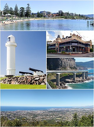
Wollongong, colloquially referred to as The Gong, is a city located in the Illawarra region of New South Wales, Australia. The name is believed to originate from the Dharawal language, meaning either 'five islands/clouds', 'ground near water' or 'sound of the sea'. Wollongong lies on the narrow coastal strip between the Illawarra Escarpment and the Pacific Ocean, 85 kilometres south of central Sydney. Wollongong had an estimated urban population of 302,739 at June 2018, making it the third-largest city in New South Wales after Sydney and Newcastle and the tenth-largest city in Australia by population. The city's current Lord Mayor is Gordon Bradbery AM who was elected in 2021.

Kiama is a coastal town 120 kilometres south of Sydney in the Illawarra. One of the main tourist attractions is the Kiama Blowhole. Kiama features several popular surfing beaches and caravan parks, and numerous alfresco cafes and restaurants. Its proximity to the south of Sydney makes it an attractive destination for many day-trippers and weekenders.
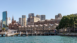
The Rocks is a suburb, tourist precinct and historic area of Sydney's city centre, in the state of New South Wales, Australia. It is located on the southern shore of Sydney Harbour, immediately north-west of the Sydney central business district.

Randwick is a suburb in the Eastern Suburbs of Sydney, in the state of New South Wales, Australia. Randwick is located 6 kilometres south-east of the Sydney central business district and is the administrative centre for the local government area of the City of Randwick. The postcode is 2031.

The Macquarie Lighthouse, also known as South Head Upper Light, is the first, and is the longest serving, lighthouse site in Australia. It is located on Dunbar Head, on Old South Head Road, Vaucluse in the Municipality of Woollahra local government area of New South Wales, Australia. The lighthouse is situated approximately 2 kilometres (1 mi) south of South Head near the entrance to Sydney Harbour. There has been a navigational aid in this vicinity since 1791 and a lighthouse near the present site since 1818. The current heritage-listed lighthouse was completed in 1883. The lighthouse and associated buildings were designed by James Barnet and built from 1881 to 1883.

The Sydney central business district (CBD) is the historical and main commercial centre of Sydney. The CBD is Sydney's city centre, or Sydney City, and the two terms are used interchangeably. Colloquially, the CBD or city centre is often referred to simply as "Town" or "the City". The Sydney city centre extends southwards for about 3 km (2 mi) from Sydney Cove, the point of first European settlement in which the Sydney region was initially established. Due to its pivotal role in Australia's early history, it is one of the oldest established areas in the country.
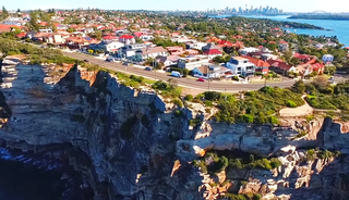
Vaucluse is an eastern suburb of Sydney, in the state of New South Wales, Australia. It is located 8 kilometres (5 mi) north-east of the Sydney central business district, in the local government areas of Waverley Council and the Municipality of Woollahra.

The City of Blue Mountains is a local government area of New South Wales, Australia, governed by the Blue Mountains City Council. The city is located in the Blue Mountains, on the Great Dividing Range at the western edge of the Greater Sydney Region in New South Wales, Australia.

Woollahra Municipal Council is a local government area in the eastern suburbs of Sydney, in the state of New South Wales, Australia. Woollahra is bounded by Sydney Harbour in the north, Waverley Council in the east, Randwick City in the south and the City of Sydney in the west.

Millers Point is an inner-city suburb of Sydney, in the state of New South Wales, Australia. It is on the north-western edge of the Sydney central business district, adjacent to The Rocks and is part of the local government area of the City of Sydney.

The Sydney Heads are a series of headlands that form the 2 km (1.2 mi) wide entrance to Sydney Harbour in Sydney, New South Wales, Australia. North Head and Quarantine Head are to the north; South Head and Dunbar Head are to the south; and Middle Head, Georges Head, and Chowder Head are to the west and within the harbour. The Heads are contained within the Sydney Harbour National Park.

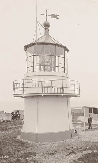
Hornby Lighthouse, also known as South Head Lower Light or South Head Signal Station, is a heritage-listed active lighthouse located on the tip of South Head, New South Wales, Australia, a headland to the north of the suburb Watsons Bay. It marks the southern entrance to Port Jackson and Sydney Harbour, as well as lighting the South Reef, a ledge of submerged rocks. It is the third oldest lighthouse in New South Wales. Designed by Mortimer Lewis and listed on the Register of the National Estate and on the New South Wales State Heritage Register since 2 April 1999, with the following statement of significance:
A dominant Sydney landmark which appears to have been in continuous use since the 1840s as a controlling point for shipping entering and leaving Port Jackson. The building complex, designed by the Colonial Architect Mortimer Lewis in the early 1840s, is an architectural important example of an early Victorian public work associated with port activities.

Norah Head, originally known as Bungaree Noragh Point, is a headland and a coastal village in Central Coast Council on the Central Coast of New South Wales, Australia. Norah Head is known for its great surfing and clear beaches like Soldiers Beach near Wyrrabalong National Park and Pebbly Beach with Norah Head Rock Pool. The town is home to Norah Head Lighthouse with scenic views along the coast.

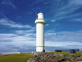
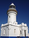
Wollongong Breakwater Lighthouse, also known as Wollongong Harbour Lighthouse, is a historic lighthouse situated on the southern breakwater of the heritage-listed Wollongong Harbour, in Wollongong, New South Wales in Australia. Wollongong is the only place in the east of Australia to have two lighthouses located in close proximity of each other, the other being Wollongong Head Lighthouse. While no longer used, the lighthouse was restored in 2002 as operational and is listed an official local heritage building.
The city of Wollongong has a distinct geography. It lies on a narrow coastal plain flanked by the Pacific Ocean to the east and a steep sandstone precipice known as the Illawarra Escarpment to the west, most notably Mount Keira, joined to the escarpment by a high saddle.
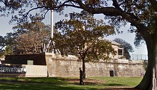
Fort Phillip was a citadel style fort constructed as part of the first defensive works of the penal settlement of Sydney, located on Observatory Hill in the Sydney suburb of Millers Point, New South Wales, Australia. The fort has been demolished and the local government heritage-listed site repurposed as the Sydney Observatory.

The Bradleys Head Light is an active heritage-listed lighthouse at Bradleys Head, a headland protruding from the north shore of Sydney Harbour, within Mosman, Mosman Council, Sydney, New South Wales, Australia. It is the sibling of Robertson Point Light. The site is owned and managed as part of the Sydney Harbour National Park by the NSW National Parks and Wildlife Service, an agency of the Government of New South Wales; while the light is managed and operated by Sydney Ports Corporation. It was added to the New South Wales State Heritage Register on 18 April 2000.
Nobbys Head Light is an active lighthouse on Nobbys Head, a headland on the south side of the entrance to Newcastle Harbour, New South Wales, Australia. An image of the lighthouse is included in the Coat of Arms of the City of Newcastle.

The Kiama Reservoirs are heritage-listed reservoirs at Irvine Street, Kiama, Municipality of Kiama, New South Wales, Australia. They are owned by Sydney Water. It was added to the New South Wales State Heritage Register on 15 November 2002.

Wollongong Harbour Precinct is a heritage-listed shipping harbour at Cliff Road and Endeavour Drive, in Wollongong, New South Wales, Australia. It was built in 1837. The historic precinct includes Belmore Basin, Government Dam, Government Basin, Stockade Point, Flagstaff Hill, Signal Hill, Brighton Beach, Boat Harbour and Fortress Hill. It was added to the New South Wales State Heritage Register on 5 May 2010.