Smoky Cape Lighthouse

Last updated

Smoky Cape Lighthouse
SmokyCapeLighthouse.JPG
Smoky Cape Lighthouse, near South West Rocks
Smoky Cape Lighthouse
Location Smoky Cape
New South Wales
Australia
Coordinates 30°55′22.4″S153°05′14.5″E / 30.922889°S 153.087361°E / -30.922889; 153.087361
Tower
Constructed1891
Constructionconcrete tower
Automated1988
Height17.4 metres (57 ft)
Shapeoctagonal tower with balcony and lantern attached to 1-story building
Markingswhite tower and building
Power sourcemains electricity  OOjs UI icon edit-ltr-progressive.svg
OperatorAustralian Maritime Safety Authority
Heritagelisted on the Commonwealth Heritage List, Heritage Act — State Heritage Register  OOjs UI icon edit-ltr-progressive.svg
Light
Focal height128 metres (420 ft)
LensFirst order Fresnel lens
Intensity1,000,000  cd
Range26 nautical miles (48 km; 30 mi) [1]
Characteristic Fl (3) W 20s.

Smoky Cape Lighthouse is a heritage-listed active lighthouse located on Smoky Cape, a headland in Arakoon east of the town of South West Rocks, Kempsey Shire, New South Wales, Australia, and within the Hat Head National Park. It directs boats towards the entrance to the Macleay River, which is located just to the north of the lighthouse. [2]

Contents

It is one of the last major lighthouse complexes designed by the New South Wales colonial architect of the time, James Barnet, [3] and was one of Australia's last lighthouses to be designed for architectural excellence. [4] Standing on a granite headland 111 metres (364 ft) above the sea, its light is the highest in New South Wales. [5]

It was added to the New South Wales State Heritage Register on 2 April 1999. [6]

History

The South West Rocks area was well known for many years because of its prominent coastal geography. A journal entry recorded on Sunday May 13, 1770 by Captain James Cook describes a point "or a head land, on which we saw fires that produced a great quantity of smoke, bore W. distant four leagues. To this point, I gave the name of Smoky Cape; it is of a considerable height, and over the pitch of the Point, is a round hillock; within it are two others, much higher and larger and within them the land is very low". Earliest European contact was not until 1816, when the brig, Trial, hijacked by convicts was wrecked at Trial Bay. Subsequently, explorer John Oxley visited the area in 1817. Trial Bay was noted early as a valuable haven for passing ships during southerly gales because of its northerly aspect and position midway between Sydney and Brisbane. Shipping was the primary mode of trade and transport for the eastern seaboard communities. [6]

More than twenty wrecks have occurred in the area of the headland, several of them with losses of life. Three men died when the ketch Woolloomooloo was wrecked in Trial Bay in 1864 and nine died in the wreck of the brig Annie Ogle in 1875. A number of ships have been wrecked in the Bay area with more lost around the headland and immediate coastline. The first action to establish a light at Smoky Cape was taken by Alexander Kethel, member for West Sydney in the New South Wales Legislative Assembly, who in 1886 passed a resolution stating that, for the benefit of the increasing coast trade and navigation it was necessary to erect a lighthouse at Smoky Cape. [6]

A sum of 18,000 pounds was set aside for the construction of the complex. The Colonial Architect, James Barnet, who played an important role in the design and construction of lights at South Solitary Island, Montague Island and Green Cape, selected the site and prepared the necessary documentation. During the design stage major changes in organisation occurred. James Barnet was dismissed in 1890 and the office of the Colonial Architect was replaced with that of Government Architect. The project was then handed to C. W. Darley, Engineer-in-Chief for Harbours and Rivers. Barnets original design was however used for the Lighthouse. [6]

Tenders for the work were called in January 1889 and the offer from Messrs. Oakes and Company was successful. The contract called for the construction of the tower and annex, the head keeper's residence and semi detached assistant keepers cottages, a coach house and stables. All were to be erected on an 81 acres reserve, 128 metres above sea level. By 1889 construction was well underway and a notice was given to mariner's informing them of the construction of the lighthouse with full particulars coming at a later date. It was reported the contractor, a Mr Oakes died during the construction of the complex, however it was completed by his heirs within budget. [6]

The light was first exhibited on the 15 April 1891. The official ceremony, attended by Darley and members of the Marine Board, taking place on the 29 April 1891. In 1912 the original light source was replaced and in 1962 was changed again to an electric lamp and new thrust bearing pedestal system. [6]

As a result of the Commonwealth Lighthouses Act of 1911, management of the lighthouse was transferred in 1915 to Federal control because of its status as a coastal light. [4]

Since 1939, the lighthouse has been an Australian Bureau of Meteorology site for the gathering of climate statistics. [7]

During the World War 2, the lighthouse precinct was used for military purposes. There was a searchlight battery and light gun emplacement, and possibly a radio room, operating there at that time. The concrete remains of the military installation are still visible. [5]

In 1962 the light was electrified and around 1988 it was automated. The optic system is still the original first order Fresnel lens. [4] [8]

On May 14, 1998, Smoky Cape was the first NSW Parks and Wildlife Service lighthouse to be opened for tours. [9]

Design

Lighthouse plans, 1888 Smoky Cape Light, lighthouse plans, 1888.jpg
Lighthouse plans, 1888
Keepers' quarters plans, 1888 Smoky Cape Light, plan of keepers' quarters, 1888.jpg
Keepers' quarters plans, 1888
Plan of site, 1888 Smoky Cape Light, plan of site, 1888.jpg
Plan of site, 1888

The lighthouse's design is unusual for its octagonal tower, and was so designed because it was easier to cast the tower in the octagonal formwork than round formwork. [4] It has a single-story pavilion entrance, cast-iron staircase and distinctive gunmetal balustrade. [10] It is one of only three nineteenth century mass concrete lighthouses in NSW (the others being South Solitary Island Lighthouse and Green Cape Lighthouse). [5] The fact that it has its original Chance Brothers revolving apparatus and lens, and lantern house, makes it an important example of late nineteenth century industrial maritime technology. [5]

Description

Context

Smoky Cape is located to the south east of South West Rocks a seaside resort town situated at the mouth of the Macleay River, 35 kilometres north east of Kempsey and midway between Coffs Harbour and Port Macquarie. South West Rocks has a variety of beaches facing in different directions. East of the township is Laggers Point which extends north west with a west facing beach at its base. Southeast of the point are a number of small protected beaches such as Horseshoe Bay and Little Bay. Gap Beach and North Smoky are long stretches of forest fringed beaches. Trial Bay Gaol, which occupies Laggers Point is a prominent tourist attraction dating from the same period as Smoky Cape.

The Lighthouse is sited on the top of a bluff, which then falls away to the sea below. The support buildings are set below and behind the lighthouse for more protection from adverse weather. The main cottage and two assistants cottages are sited on level platforms, cut into the steep slopes and stabilised by high concrete retaining walls. The stables are set well below the cottages, near the entry to the precinct. The site rises steeply from the carpark to the Lighthouse and its narrow pathway is known as "Heart Attack Hill". There is little on site car parking. Cars presently can drive up a narrow driveway, but must traverse all the way up the lighthouse forecourt before turning around and descending to the small grassed plot in front of the Head Lighthouse keeper's cottage

Buildings and structures

The Lighthouse Precinct consists of:

An historic view of the lighthouse Smoky Cape historic.jpg
An historic view of the lighthouse

The Lighthouse Tower

The Lighthouse is octagonal with large single storey entry pavilion. Constructed in mass concrete the tower is 17.4 metres tall and has a Chance Bros. lantern and lens. Cast iron stairs lead up to the gallery level. [6]

An early description of the tower refers to two storeys with iron floors and staircases and walls of mass concrete. The gallery round lantern is of granite supported on moulded granite cantilevers with gun metal railing. The tower is entered from an enclosed passage protected by a screen wall which is constructed around the base of the structure. The floors of the storerooms are paved in concrete and cemented. The tower is divided into two storeys with iron floors and staircases. The walls are 920mm thick at the base and taper to 620mm at the top and are constructed of mass concrete using locally mined granite as the aggregate and are cemented externally and internally. The gallery floor of the lantern is formed of granite voussoir blocks supported on molded granite brackets. An ornate metal railing featuring Queen Victoria's mark is used for the handrailing at this level. [6]

The tower walls feature a number of openings including a light opening located below the balcony which housed a subsidiary red light to cover Fish Rock. The tower is entered from an enclosed passage which also accesses the two store rooms and are also constructed of mass concrete. A screen wall also of mass concrete is built around the tower. [6]

The ground floor rooms were originally used as store and work room. In 1912 the original burner was replaced by an incandescent vaporised kerosene burner. Again in 1962 the light was altered to a mains electric operation with an increased power. The structure has also undergone a number of other fabric alterations including the roofing to the pavilion which was replaced in zincalume in 1990. [6]

The Lighthouse is maintained by AMSA and has recently been painted. The original optic remains but the light source has been updated. The light still operates at night and is screened from view towards the settled areas to the south west. [6]

Head Lighthouse Keeper's Cottage

The Headkeeper's Quarters designed in 1888 is also constructed in concrete with rendered finish. The building was constructed with two bedrooms, sitting room Inspecting Officer's Room, dining room, kitchens and stores. Most of the building was surrounded by verandah with the corner windbreaks at the north and south eastern corners. The building extends from the north western corner and incorporates store and enclosure forming a courtyard which houses one of the underground water tanks. The building also has verandahs on the northern and southern facades which are connected by a central passage. Another verandah is located on the eastern facade of the building and faces a concrete retaining wall. [6]

Assistant Keeper's Cottages

The Assistants quarters are two semi-detached cottages originally containing four rooms, with kitchen and store areas. The buildings were also constructed of mass concrete cement rendered externally and plastered internally. The roofs originally clad in galvanised iron. [6]

The northern residence has the characteristic corner wind break at the north western corner flanked by two open verandahs on the northern and western facades. A verandah located on the eastern facade of the building was enclosed during the 1970s, however the kitchen and store areas continue to enclose the courtyard space to the east of the building. A concrete retaining wall forms the eastern boundary of the courtyard. All of the ceilings were battened during the 1920s through to the 1940s over either the original lath and plaster or later fibrous plaster. The ceilings to the lobby and kitchen appear to be fibre board with timber battens. [6]

The northern residence now has three bedrooms, a door opening was made in the dividing party wall between the two residences and partitions erected to facilitate the use of an extra bedroom. The other, southern residence has two bedrooms in addition to kitchen, bathroom and outside toilets. Enclosed balconies provide additional space. The residences generally feature hipped roofs with painted brick chimneys and skillion roof verandahs supported on simply decorated timber posts. [6]

A car park and sealed access road were added in the 1970s. [6]

Other structures and elements

Three cement rendered underground water tanks remain the capacity in proportion with each residence. The accompanying pumps however have been removed. A modern steel water tank has been constructed in the courtyard of northern assistant keeper's residence. Paving, fencing, retaining walls and remnant gardens surround the complex. The footings of the flagstaff remain in front of the lighthouse, but the flagstaff has been removed. It was an integral part of the operation of the Lighthouse and can be partly seen in the AMSA brochure on the Lighthouse. [6]

Operation and tourism

The lighthouse is operated by the Australian Maritime Safety Authority and is classified by the National Trust of Australia (NSW).

Its nearest lighthouses are South Solitary Island Lighthouse north of Coffs Harbour, to the north, and Tacking Point Lighthouse at Port Macquarie, to the south.

The lighthouse complex is located in Hat Head National Park. The head keeper's cottage is now run as a bed and breakfast, [8] and two other cottages as holiday houses, leased from the NSW National Parks and Wildlife Service.

The cape is a popular point for whale-watching.[ citation needed ]

Heritage listing

Smoky Cape Lightstation and its setting are highly significant as one of a collection of lighthouses which combine the natural values of a rugged coastal environment with the cultural values of a prominent landmark. Built as an isolated outpost of European settlement it demonstrates the development of coastal shipping in the late 19th century. The light tower retains its original function today using recent technology to allow for automated operation. It is a notable work of NSW Colonial Architect James Barnet which retains components of 19th-century lighthouse technologies. This site retains evidence of cultural values, both Aboriginal and European which demonstrates the changing uses of the site, against a constant of natural values. [6]

Smoky Cape Lighthouse was listed on the New South Wales State Heritage Register on 2 April 1999 having satisfied the following criteria: [6]

The place is important in demonstrating the course, or pattern, of cultural or natural history in New South Wales.

Smoky Cape was named by Captain Cook in 1770 for the large number of fires observed along the range. The Lighthouse precinct and Trial Bay Goal together provide a fine example of Colonial architecture and planning and of Colonial government settlement in the area. World War 2 radar installations and ruins show the more recent use of the area for defence purposes. James Barnet designed a series of lighthouse towers in NSW which are reported as being the most architecturally sophisticated in Australia. Smoky Cape retains the distinctive bracketed capital and gunmetal balcony balustrade characteristic to Barnet's design. The pavilion entrance is also a feature reintroduced by Barnet and in evidence at Smoky Cape. The cast-iron stair is also a good example of its type. [6]

The place is important in demonstrating aesthetic characteristics and/or a high degree of creative or technical achievement in New South Wales.

Smoky Cape is an outstanding and relatively intact example of a late Victorian Lightstation unique in NSW for the use of in-situ mass concrete in the construction of its main buildings. The lighthouse is a fine example constructed in an unusual hexagonal shape with a rare first order Chance Bros. rotating optic. The residences display the robust design typical of Barnet's work, planned to embody the hierarchy of the keepers. Each has a view to the tower. The design is more elaborate than its contemporaries in other States. The natural setting provides a picturesque landscape quality with a sense of isolation accentuated by the siting, with no other man-made elements visible from most of the headland or beaches. [6]

The place has a strong or special association with a particular community or cultural group in New South Wales for social, cultural or spiritual reasons.

The Smoky Range is significant to the Aboriginal populations with a number of mythological associations. In addition, the lightstation and its setting have significance to Europeans as a remote outpost continuously occupied for over 100 years and closely associated with the maritime history of the area. It is a place that attracts many visitors to admire its character, setting and history. It is highly regarded by local and regional populations of the area as one of the oldest and substantially intact building complexes surviving from the Colonial era. The location offers scope for the interpretation of coastal processes in conjunction with cultural values. [6]

The place has potential to yield information that will contribute to an understanding of the cultural or natural history of New South Wales.

Smoky Cape is part of a cohesive group of late 19th- and early 20th-century lightstations in NSW each of which demonstrates the incremental changes in the design and construction of the various complexes. The tower and houses are constructed of mass concrete using aggregate of locally quarried granite and cement rendered both internally and externally. The use of concrete in Australian lighthouses was relatively widespread. In NSW, however, Green Cape and Smoky Cape lighthouses are the only known in-situ concrete towers and both are relatively early uses of concrete. Throughout Australia Smoky Cape is one of approximately 10 in-situ concrete towers constructed prior to 1920. The optic, cast-iron and copper lantern house are examples of the late 19th-century industrial technology. The optic is rare due to its detailed configuration consisting of triple panels which provide the triple group flash. One of numerous 12' diameter Chance lanterns, it is one of only four known to have both a trapezoidal glazing pattern and Trinity type vent. [6]

The place possesses uncommon, rare or endangered aspects of the cultural or natural history of New South Wales.

Early use of mass concrete, together with unusual technology in lantern and lens. [6]

The place is important in demonstrating the principal characteristics of a class of cultural or natural places/environments in New South Wales.

Representative of the work of James Barnet, NSW Colonial Architect. [6]

See also

Notes

  1. According to "Lighthouses of Australia Inc". List of Lights says 25 nautical miles (46 km; 29 mi).
  2. "Smokey Cape Lighthouse Photo Gallery". Archived from the original on 12 October 2008. Retrieved 13 February 2009.
  3. Searle, Garry. "Smoky Cape". Lighthouses of New South Wales. SeaSide Lights.
  4. 1 2 3 4 "Smoky Cape Lighthouse". Lighthouses of New South Wales. Lighthouses of Australia Inc.
  5. 1 2 3 4 "Smoky Cape Lighthouse (listing CHL105604)". Australia Heritage Places Inventory. Department of Sustainability, Environment, Water, Population and Communities.
  6. 1 2 3 4 5 6 7 8 9 10 11 12 13 14 15 16 17 18 19 20 21 22 23 24 25 "Smoky Cape Lighthouse Group". New South Wales State Heritage Register . Department of Planning & Environment. H01007. Retrieved 2 June 2018. CC BY icon.svg Text is licensed by State of New South Wales (Department of Planning and Environment) under CC-BY 4.0 licence .
  7. "Climate Statistics for Australian Locations". Archived from the original on 11 October 2008. Retrieved 16 February 2009.
  8. 1 2 Rowlett, Russ. "Lighthouses of Australia: Northern New South Wales". The Lighthouse Directory. University of North Carolina at Chapel Hill . Retrieved 2 May 2010.
  9. Lighthouses of Australia. June 1998 Bulletin
  10. Smoky Cape Lighthouse

Related Research Articles

<span class="mw-page-title-main">Macquarie Lighthouse</span> Lighthouse in New South Wales, Australia

The Macquarie Lighthouse, also known as South Head Upper Light, is the first, and is the longest serving, lighthouse site in Australia. It is located on Dunbar Head, on Old South Head Road, Vaucluse in the Municipality of Woollahra local government area of New South Wales, Australia. The lighthouse is situated approximately 2 kilometres (1 mi) south of South Head near the entrance to Sydney Harbour. There has been a navigational aid in this vicinity since 1791 and a lighthouse near the present site since 1818. The current heritage-listed lighthouse was completed in 1883. The lighthouse and associated buildings were designed by James Barnet and built from 1881 to 1883.

<span class="mw-page-title-main">Hornby Lighthouse</span> Lighthouse in New South Wales, Australia

Hornby Lighthouse, also known as South Head Lower Light or South Head Signal Station, is a heritage-listed active lighthouse located on the tip of South Head, New South Wales, Australia, a headland to the north of the suburb Watsons Bay. It marks the southern entrance to Port Jackson, as well as lighting the South Reef, a ledge of submerged rocks. It is the third oldest lighthouse in New South Wales. Designed by Mortimer Lewis and listed on the Register of the National Estate and on the New South Wales State Heritage Register since 2 April 1999, with the following statement of significance:

A dominant Sydney landmark which appears to have been in continuous use since the 1840s as a controlling point for shipping entering and leaving Port Jackson. The building complex, designed by the Colonial Architect Mortimer Lewis in the early 1840s, is an architectural important example of an early Victorian public work associated with port activities.

<span class="mw-page-title-main">Green Cape Lighthouse</span> Lighthouse in New South Wales, Australia

The Green Cape Lighthouse is a heritage-listed lighthouse located at the tip of Green Cape, a headland forming the northern boundary of Disaster Bay, in southern New South Wales, Australia. It is the southernmost lighthouse in New South Wales and Australia's first lighthouse built in concrete. At 29 metres (95 ft) it is also the tallest lighthouse in New South Wales. It marks Green Cape on the northerly shore-hugging sailing course.

<span class="mw-page-title-main">Cape Byron Light</span> Lighthouse in New South Wales, Australia

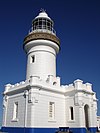
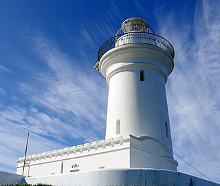
Cape Byron Light, also called Cape Byron Lightstation, is an active heritage-listed lighthouse and now interpretative centre, interpretative space, maritime museum, administration office, retail building, accommodation, tourist attraction and visitor attraction located at Lighthouse Road, Byron Bay, Cape Byron, Byron Shire, New South Wales, Australia. It was designed by Charles Harding and Cecil W. Darley and built from 1899 to 1901 by Messrs Mitchell & King. It is also known as Cape Byron Lightstation, Byron Bay Lighthouse, Cape Byron Headlan and Cape Byron Headland Reserve. The property is owned by NSW National Parks & Wildlife Service.

<span class="mw-page-title-main">Montague Island Light</span> Lighthouse in New South Wales, Australia

The Montague Island Light is a heritage-listed active lighthouse located on Barunguba / Montague Island, an island in the Tasman Sea, 9 kilometres (5.6 mi) offshore from Narooma on the south coast of New South Wales, Australia. The lighthouse is located at the highest point of the island. It was designed by James Barnet and NSW Colonial Architect and built from 1878 to 1881 by J. Musson and completed By W. H. Jennings. It is also known as the Montague Island Lightstation and its setting. The property is owned by the Office of Environment and Heritage, an agency of the Government of New South Wales. It was added to the New South Wales State Heritage Register on 2 April 1999, and the Commonwealth Heritage List on 22 June 2004.

<span class="mw-page-title-main">Norah Head Light</span> Lighthouse in New South Wales, Australia

Norah Head Light is an active lighthouse located at Norah Head, a headland on the Central Coast, New South Wales, Australia, close to Toukley. It is the last lighthouse of the James Barnet style to be built, and the last staffed lighthouse constructed in New South Wales.

<span class="mw-page-title-main">Barrenjoey Head Lighthouse</span> Lighthouse in New South Wales, Australia

<span class="mw-page-title-main">Point Stephens Light</span> Lighthouse in New South Wales, Australia

The Point Stephens Light is a heritage-listed active lighthouse located on Point Stephens, a point on an unnamed headland at the east of Fingal Bay, 4.25 km (2.64 mi) south of the entrance of Port Stephens, New South Wales, Australia. The light serves to assist vessels entering Port Stephens. It is considered an endangered lighthouse due to remote location and old age.

<span class="mw-page-title-main">South Solitary Island Light</span> Lighthouse near Coffs Harbour in New South Wales, Australia

South Solitary Island Light is an active lighthouse on South Solitary Island, an island within the Solitary Islands Marine Park, about 15 kilometres (9.3 mi) northeast of Coffs Harbour, New South Wales, Australia. The lighthouse is located at the summit of the island. It is considered the most isolated lighthouse on the New South Wales coast. It was first in New South Wales to use kerosene over colza oil, and the last to do so before converting to electric power.

<span class="mw-page-title-main">Sugarloaf Point Light</span> Lighthouse in New South Wales, Australia

Sugarloaf Point Light, also known as Seal Rocks Lighthouse, is an active lighthouse located on Sugarloaf Point, a point about 3 kilometres (1.9 mi) southeast of Seal Rocks, Mid-Coast Council, New South Wales, Australia. It guards Seal Rocks, a treacherous rock formation to the south. It is the first lighthouse designed by James Barnet, and built from 1874 to 1875 by John McLeod. It is also one of only two towers in Australia with an external stairway. It is also known as Sugarloaf Point Lightstation Group, Seal Rocks Lightstation Complex and Sugarloaf Point Lighthouse. The property is owned by National Parks and Wildlife Service. It was added to the Commonwealth Heritage List on 22 June 2004; on the New South Wales State Heritage Register on 22 February 2019; and on the Register of the National Estate on 10 April 1989.

<span class="mw-page-title-main">Booby Island Light</span> Lighthouse

Booby Island Light is an active heritage-listed lighthouse located on Booby Island in the Shire of Torres, near the tip of Cape York Peninsula, west of Prince of Wales Island, within the Endeavour Strait, Queensland, Australia. It marks the western entrance to the navigation channel through the Torres Strait. It was the last of the major lights to be constructed along the Queensland coast.

<span class="mw-page-title-main">Sandy Cape Light</span> Lighthouse

Sandy Cape Light is a heritage-listed active lighthouse located on Sandy Cape, the most northern point on K'gari, Queensland, Australia. It stands about 6 kilometres (3.7 mi) southwest of the northeastern tip of the island. It is the tallest lighthouse in Queensland. Built in 1870, it is the second major lighthouse to be built in Queensland after its formation in 1859. It is one of the first lighthouses in Australia to be constructed using bolted prefabricated segments of cast iron, and one of only two such lighthouses in Queensland, the other being its sibling, Bustard Head Light.

<span class="mw-page-title-main">Cape Capricorn Light</span> Lighthouse in Queensland, Australia

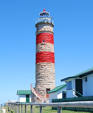
Cape Capricorn Light is an active heritage-listed lighthouse located on Cape Capricorn, a coastal headland on the northeast point of Curtis Island, in Gladstone Region, Central Queensland, Australia. The lighthouse, constructed in 1964, is the third at this site, following a timber frame lighthouse constructed in 1875 and a concrete lighthouse constructed around 1937. It was added to the Queensland Heritage Register on 31 August 2001.

<span class="mw-page-title-main">Lady Elliot Island Light</span> Lighthouse

Lady Elliot Island Light is an active lighthouse located on Lady Elliot Island, the southernmost coral cay of the Great Barrier Reef, 46 nautical miles north-east of Bundaberg, Queensland, Australia. The lighthouse is located on the western side of the island. It was the third lighthouse erected in Queensland after its formation in 1859 and the first in Australia to be constructed of a timber frame clad with iron plates. The original lighthouse was deactivated in 1995 and the light was replaced by a modern skeletal tower standing close to the original lighthouse.

<span class="mw-page-title-main">Cape Moreton Light</span> Lighthouse in Queensland, Australia

Cape Moreton Light, also listed as North Point Range Rear Light, is a heritage-listed active lighthouse located on Cape Moreton, a rocky headland located at the north eastern tip of Moreton Island, a large sand island on the eastern side of Moreton Bay, on the coast of South East Queensland, Australia. It marks the northern entrance to Moreton Bay and Brisbane and also serves as the rear light for the North Point Range. With its two distinctive red bands, it also serves as a daymark. It is the oldest lighthouse in Queensland, and the only one to be built by the New South Wales Government before the separation of Queensland, which took place in 1859. It is also the only lighthouse in Queensland to be built of stone.

<span class="mw-page-title-main">Cape Cleveland Light</span> Lighthouse in Queensland, Australia

Cape Cleveland Light is an active heritage-listed lighthouse located on the northern tip of Cape Cleveland, a promontory projecting into the Coral Sea west of Cleveland Bay in the locality of Cape Cleveland about 40 kilometres (25 mi) east of Townsville, Queensland, Australia. The lighthouse marks the northern point of the Cape, and the entrance to Cleveland Bay.

<span class="mw-page-title-main">Dent Island Light</span> Lighthouse

Dent Island Light is an active lighthouse on Dent Island, a small island off the coast of Queensland, Australia, part of the Whitsunday Group of the Whitsunday Islands. Located on the southwest tip of the island, the light guides ships navigating the Whitsunday Passage, between Whitsunday Island and the islands to the west, and marks the Dent Island Passage.

<span class="mw-page-title-main">Double Island Point Light</span> Lighthouse

Double Island Point Light is an active lighthouse located at the summit of Double Island Point, a coastal headland within the Cooloola section of the Great Sandy National Park. It is located at the southern end of Wide Bay, 70 kilometres (43 mi) north of Noosa Heads, Queensland, Australia.

<span class="mw-page-title-main">Low Isles Light</span> Lighthouse

Low Isles Light, also known as Low Islets Light or Low Island Light, is an active lighthouse located on Low Island, a coral cay which together with Woody Island forms the Low Isles group, about 13 kilometres (8.1 mi) northeast of Port Douglas, Queensland, Australia. The island is situated on the western edge of the main shipping channel into the harbour of Port Douglas, and it marks the entrance to the channel. Built in 1878, it was the first lighthouse in Far North Queensland and more specifically the first to light the Inner Passage of the Great Barrier Reef. Its construction is typical to Queensland lighthouses of the time, timber frame clad with galvanized iron, and it is the fourth lighthouse of this type constructed in Queensland, though it is the first of them to use portholes.

<span class="mw-page-title-main">Norah Head Lightstation Precinct</span> Lighthouse in New South Wales, Australia

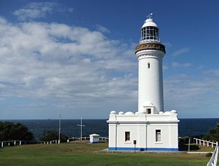
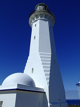
Norah Head Lightstation Precinct is a heritage-listed former lighthouse precinct located at Bush Street, Norah Head in the Central Coast local government area of New South Wales, Australia. The Norah Head lighthouse and associated buildings were designed by Cecil W. Darley and built in 1903. The precinct was added to the New South Wales State Heritage Register on 13 April 2007.

References

Bibliography

Attribution

CC BY icon-80x15.png This Wikipedia article contains material from Smoky Cape Lighthouse Group , entry number 01007 in the New South Wales State Heritage Register published by the State of New South Wales (Department of Planning and Environment) 2018 under CC-BY 4.0 licence , accessed on 2 June 2018.