
Darling Harbour is a harbour adjacent to the city centre of Sydney, New South Wales, Australia that is made up of a large recreational and pedestrian precinct that is situated on western outskirts of the Sydney central business district.

Palm Beach is a suburb in the Northern Beaches region of Greater Sydney, in the state of New South Wales, Australia. Palm Beach is located 41 kilometres (25 mi) north of the Sydney central business district, in the local government area of Northern Beaches Council. Palm Beach sits on a peninsula at the end of Barrenjoey Road near Pittwater and is the northernmost beach in the Greater Sydney Metropolitan area. The population of Palm Beach was 1,593 as at the 2016 census.

Town Hall railway station is a heritage-listed underground commuter rail station located in the centre of the Sydney central business district in New South Wales, Australia. The station opened on 28 February 1932. It is named after the Sydney Town Hall, located directly above the station.
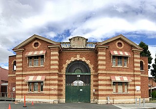
H.M. Prison Brisbane, commonly known as Boggo Road Gaol, was Queensland's main prison from the 1880s to the 1980s. By the time it closed, it had become notorious for poor conditions and rioting. Located on Annerley Road in Dutton Park, an inner southern suburb of Brisbane, it is the only surviving intact gaol in Queensland that reflects penological principles of the 19th century. After closing in 1992, the larger 1960s section was demolished, leaving the heritage listed section.
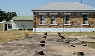
Fannie Bay Gaol is a historic gaol in Fannie Bay, Northern Territory, Australia. The gaol operated as Her Majesty's Gaol and Labour Prison, from 20 September 1883 until 1 September 1979. Glen SUTTON was the last Superintendent of Fannie Bay and the first Superintendent of the new gaol at Berrimah.
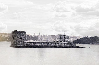
Fort Denison, part of the Sydney Harbour National Park, is a protected national park that is a heritage-listed former penal site and defensive facility occupying a small island located north-east of the Royal Botanic Garden and approximately 1 kilometre (0.62 mi) east of the Opera House in Sydney Harbour, New South Wales, Australia. The island is also known as Mattewanye or Muddawahnyuh in the Eora language, and as Pinchgut Island.

The Berrima Correctional Centre was an Australian prison, located at Berrima, New South Wales. The Centre was operational between 1839 and 2011 with a number of breaks in between, was re-opened in September 2016 and then permanently closed in 2020. Initially established as Berrima Gaol, the facility closed in 1909 and reopened in 1949 as the Berrima Training Centre. The Centre was the oldest Australian correctional facility in operation. It was added to the New South Wales State Heritage Register on 2 April 1999.

South West Rocks is a town located on the Mid North Coast of New South Wales, Australia, near the mouth of the Macleay River. It is approximately 40 km (25 mi) from Kempsey. Jerseyville is located nearby.

Crescent Head is a town on the Mid North Coast, 340 km north-northeast of Sydney, in The Kempsey Shire local government area of New South Wales, Australia. At the 2021 census, Crescent Head had a population of 978 people. Its major industries include tourism and fishing. It has a 6-hole golf course overlooking the sea.

German Australians are Australians with German ancestry. German Australians constitute one of the largest ancestry groups in Australia, and German is the fifth most identified European ancestry in Australia behind English, Irish, Scottish and Italian. German Australians are one of the largest groups within the global German diaspora.

Smoky Cape is a headland in Australia on the New South Wales Mid-North Coast. It lies just east of the town of South West Rocks, and within the Hat Head National Park.
Arakoon is an eastern suburb of the town of South West Rocks in Kempsey Shire, New South Wales, Australia. At the 2016 census, Arakoon had a population of 420 people.

Tourism in Sydney forms an important part of the city's economy. The city received 12 million domestic visitors and 4.1 million international visitors in year ending June 2019. The most famous attractions include the Sydney Opera House, and the Sydney Harbour Bridge. Other attractions include the Sydney Mardi Gras, Royal Botanical Gardens, Luna Park, the beaches and Sydney Tower.

Trial Bay is a broad bay on the Mid North Coast of New South Wales, Australia. The bay faces northwards and extends from Laggers Point in the east around to Grassy Head to the west, past the town of South West Rocks and the Macleay River mouth.

Trial Bay Gaol is a heritage-listed former public works prison and internment camp at Cardwell Street, Arakoon, Kempsey Shire, New South Wales, Australia. The property is owned by the NSW National Parks and Wildlife Service. It was added to the New South Wales State Heritage Register on 14 May 2010.

Milsons Point ferry wharf is located on the northern side of Sydney Harbour serving the Sydney suburb of Milsons Point. It is next to Luna Park and the Sydney Harbour Bridge. It is served by Sydney Ferries Parramatta River and Pyrmont Bay services operated by First Fleet and RiverCat class ferries.

Macleay Island is an island in Moreton Bay, South East Queensland, Australia. The island constitutes a town and locality within the City of Redland. In the 2021 census, Macleay Island had a population of 3,193 people.

Smoky Cape Lighthouse is a heritage-listed active lighthouse located on Smoky Cape, a headland in Arakoon east of the town of South West Rocks, Kempsey Shire, New South Wales, Australia, and within the Hat Head National Park. It directs boats towards the entrance to the Macleay River, which is located just to the north of the lighthouse.

Berrima Internment Camp Huts Area is a heritage-listed former internment camp site at Argyle Street, Berrima, in the Southern Highlands of New South Wales, Australia. It formed an additional section of the former Berrima Internment Camp outside the walls of the Berrima Gaol. It was established from 1915 to 1918. The camp was also known as the Berrima PoW Camp, the German Detention Camp and the German Concentration Camp. It was added to the New South Wales State Heritage Register on 14 January 2011.

