Lighthouses by state or territory
Jervis Bay Territory
| Location | Name | Image | Coordinates | Established | Automated | Deactivated | Remarks |
|---|---|---|---|---|---|---|---|
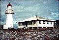
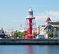
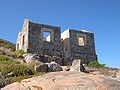
| Jervis Bay Village | Cape St George Lighthouse |  | 35°09′07″S150°45′42″E / 35.15184°S 150.76154°E | 1860 | 1889 | Destroyed to avoid confusion with Point Perpendicular Light. [37] |
New South Wales
There are several lighthouse siblings in the vicinity – lighthouses that were designed by the same architect around the same time, which are very similar by design. These include:
- Wollongong Breakwater Lighthouse and Warden Head Light, built 1872–1873, initiated by Edward Orpen Moriarty MA MInstCE
- Crowdy Head Light, Fingal Head Light, Clarence River Light (the original, now demolished), Tacking Point Lighthouse and Richmond River Light, designed by James Barnet in 1878
- Point Perpendicular Light (1899), Cape Byron Light (1901) and Norah Head Light (1903), designed by Charles Assinder Harding
- Bradleys Head Light (1905) and Robertson Point Light (1910)
- The "Disney Castles", Grotto Point Light, Parriwi Head Light, Vaucluse Bay Range Front Light and Vaucluse Bay Range Rear Light, built 1910–1911 by Maurice Festu
- The "Wedding Cakes", Eastern Channel Pile Light and Western Channel Pile Light built in 1924


Northern Territory
Most of the lighthouses in the Northern Territory were constructed by the Commonwealth Lighthouse Service during the "Golden Age of Australian Lighthouses", between 1913 and 1920. These include Cape Don Light, East Vernon Light, Emery Point Light, Cape Hotham Light and Cape Fourcroy. [50]
Of these five, three can be considered "siblings", Cape Hotham Light, Emery Point Light and Cape Fourcroy Light. They are almost identical white square skeletal towers, and they also share a similar light characteristic, three flashes every 15 second (Fl.(3) 15s). [51]
| Location | Name | Image | Coordinates | Year established | Year automated | Status | Remarks |
|---|---|---|---|---|---|---|---|
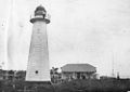
| Cobourg Peninsula | Cape Don Light |  | 11°18′28″S131°45′55″E / 11.30786°S 131.76515°E | 1917 | 1983 | active | solar powered [52] |
| Cape Fourcroy | Cape Fourcroy Light | 11°47′51″S130°01′28″E / 11.79747°S 130.02434°E | active | ||||
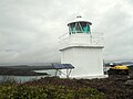
| Clarence Strait | Cape Hotham Light |  | 12°02′47″S131°17′22″E / 12.04644°S 131.28946°E | 1928 | active | ||
| East Vernon Island | East Vernon Light |  | 12°04′38″S131°05′43″E / 12.07722°S 131.09531°E | 1928 | active | ||
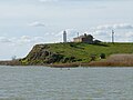
| Larrakeyah Barracks | Emery Point Light |  | 12°27′14″S130°48′56″E / 12.45382°S 130.81555°E | 1900 | active | ||
| Cox Peninsula | Point Charles Light |  | 12°23′21″S130°37′50″E / 12.38929°S 130.63068°E | 1893 | 1933 | active | survived cyclone Tracy; [53] solar powered [54] |
Queensland
Most lighthouses in Queensland were constructed in well established groups:
- Two lighthouses constructed using bolted prefabricated segments of cast iron: Sandy Cape Light and Bustard Head Light. [55]
- Eight lighthouses made of hardwood frame clad with corrugated iron: Little Sea Hill Light, Grassy Hill Light, Goods Island Light, Bay Rock Light, Old Caloundra Light, North Point Hummock Light (demolished), Gatcombe Head Light (demolished) and Bulwer Island Light. [56]
- Seven concrete towers erected between 1964 and 1979: Cape Capricorn Light, New Caloundra Light, Point Danger Light, New Burnett Heads Light, Fitzroy Island Light, Point Cartwright Light and Archer Point Light. [56]


