
Cape Beale Lightstation is an active manned lighthouse on Vancouver Island in British Columbia., Canada.

The Cape Schanck Lighthouse was built in 1859 as the second coastal lighthouse in the Australian state of Victoria. It is located on Cape Schanck, at the southernmost tip of the Mornington Peninsula. The 21 metres (69 ft) tall tower was built from limestone. The light's focal plane is situated 100 metres (330 ft) above sea level, the light characteristic is the Morse code letter "N", a long signal of 10.8 seconds followed by a flash. Depending on the bearing of the light, the colours are either white or red. Due to its powerful lantern of one million candela and a first order Fresnel lens, which was installed in 1915, the light has a range of 26 nmi (48 km).

The Cliffy Island Lighthouse is located atop Cliffy Island, a steep-sided island which is the summit of a granite submarine mountain in the Bass Strait. Cliffy Island is located about 32 kilometres directly south of Port Albert, and roughly 38 kilometres to the northeast of Wilsons Promontory Lighthouse in Victoria, Australia. The lighthouse warns approaching vessels of rocks in Bass Strait by emitting a flash of white light every five seconds. The focal plane of the lightsource and Fresnel lens is situated 52 metres above sea level. The site is managed by the Victoria Department of Conservation and Natural Resources, while the lighthouse itself is operated by the Australian Maritime Safety Authority (AMSA). The island is accessible only by helicopter, and the entire site is closed to the public.
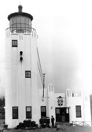
The Cape Hinchinbrook Light is a lighthouse located near the southern end of Hinchinbrook Island adjacent to Prince William Sound, in Alaska, United States.

The Sentinel Island Light is a lighthouse in Alaska adjacent to Lynn Canal.

Cape Borda Lighthouse is a lighthouse in the Australian state of South Australia located at Cape Borda on Kangaroo Island.

Cape Anguille is a headland and the westernmost point in Newfoundland, reaching into the Gulf of Saint Lawrence. It is the southern edge of St. George's Bay. Its name is derived from the French word anguille, which means eel. Close to the cape is the community of Cape Anguille.

The Cape Tourville Lighthouse is an unmanned, automatic lighthouse built in 1971 by private contractors. The road was constructed through virgin eucalypt forest, along with the powerline, with minimal disruption to the National Park. The top of the granite headland was levelled by blasting to provide the base for the lighthouse and parking area.

Whalers Bluff Lighthouse is a lighthouse on Whalers Bluff, also known as Whalers Point, in the regional city of Portland in the Western District of the state of Victoria in Australia. It stands about 1.5 km north of the city centre and overlooks Portland's harbour. It is operated by the Victorian Channels Authority, part of the Port of Melbourne Corporation.

Cape Baily Light is an active lighthouse located at Cape Baily, a headland at the south side of the entrance to Botany Bay, New South Wales, Australia. The light serves to help north-bound shipping hug the coast to avoid the strong southerly currents further out to sea.

Cape Bowling Green Light is an active lighthouse on Cape Bowling Green, a long headland ending in a long low sandspit, about 30 kilometres (19 mi) from Ayr, Queensland, Australia. The lighthouse is at the end of the headland, near the base of the sandspit. The first lighthouse at the location, established in 1874, was moved multiple times. It was prefabricated in Brisbane, shipped to the location, moved twice due to coastal erosion and finally transferred for display at the Australian National Maritime Museum at Darling Harbour in Sydney.
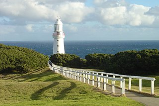
Cape Otway Lighthouse is a lighthouse on Cape Otway in southern Victoria, Australia. It is Victoria's oldest working lighthouse. During winter to spring, the lighthouse is a vantage point for land-based whale watching as migrating whales swim very close to shores.

Point Hicks Lighthouse is a lighthouse located on the Point Hicks headland, in the East Gippsland region of Victoria, Australia.

Cape Spencer Lighthouse is a lighthouse in the Australian state of South Australia located on Cape Spencer on the Yorke Peninsula in gazetted locality of Inneston. The navigation aid was originally established as an automatic beacon which was first lit in late 1950, was established after a lengthy period of lobbying of the Australian government. The automatic beacon was replaced in 1975 by an automatic lighthouse facility.

Penguin Island Lighthouse was a lighthouse located on Penguin Island at the north end of Rivoli Bay in South Australia.

Cape Martin Lighthouse is a lighthouse located on Cape Martin near Beachport at the north end of Rivoli Bay in South Australia. It was first lit in 1960. It replaced the Penguin Island Lighthouse whose light apparatus was reused in the new tower. The lighthouse was converted to mains power electricity in 1974. The original tower had a height of 4.5 metres. However, the gradual build up of sand dunes obscured the light. This problem was rectified in 1980 when the tower was raised to a height of 12 metres.

The Gabo Island Lighthouse is an active lighthouse located on Gabo Island, Victoria, Australia.

