
Port Phillip or Port Phillip Bay is a horsehead-shaped enclosed bay on the central coast of southern Victoria, Australia. The bay opens into the Bass Strait via a short, narrow channel known as The Rip, and is completely surrounded by localities of Victoria's two largest cities — metropolitan Greater Melbourne in the bay's main eastern portion north of the Mornington Peninsula, and the city of Greater Geelong in the much smaller western portion north of the Bellarine Peninsula. Geographically, the bay covers 1,930 km2 (750 sq mi) and the shore stretches roughly 264 km (164 mi), with the volume of water around 25 km3 (6.0 cu mi). Most of the bay is navigable, although it is extremely shallow for its size — the deepest portion is only 24 m (79 ft) and half the bay is shallower than 8 m (26 ft). Its waters and coast are home to seals, whales, dolphins, corals and many kinds of seabirds and migratory waders.

Searoad Ferries is an Australian company that operates a roll-on/roll-off vehicle and passenger ferry service between the heads of Port Phillip, near Melbourne, Victoria, Australia.

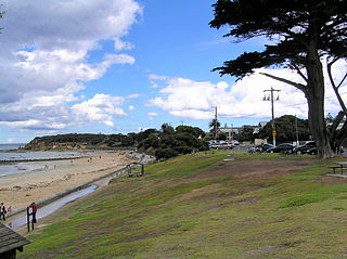
Queenscliff is a town at the south-eastern end of the Bellarine Peninsula in southern Victoria, Australia. It lies south of Swan Bay at the entrance to Port Phillip. It is the administrative centre for the Borough of Queenscliffe. At the 2021 census, Queenscliff had a population of 3,276.

The Rip, also known as The Heads, is the narrow waterway entrance connecting the Bass Strait to the bay of Port Phillip in southern Victoria, Australia, and is the only route of maritime transport into Port Phillip and thus seaport access into Melbourne and Geelong, Victoria's two largest cities. Because of large tidal flows through the relatively narrow channel from the bay to the ocean, and a high rocky seabed, The Rip is a dangerous stretch of water and has claimed numerous ships and many lives. Geographically, it is the roughly triangular area of water between the land points of Point Nepean on the Mornington Peninsula, Shortlands Bluff and Point Lonsdale on the Bellarine Peninsula, with these three forming The Heads.
Point Lonsdale is a town on the Bellarine Peninsula, near Queenscliff, Victoria, Australia. The town is divided between the Borough of Queenscliffe and the City of Greater Geelong. Point Lonsdale is also one of the headlands which, with Point Nepean, frame The Rip, the entrance to Port Phillip. The headland is dominated by the Point Lonsdale Lighthouse. At the 2016 census, Point Lonsdale had a population of 2,684. The population grows rapidly over the summer months through to the Easter period due to its popularity as a holiday destination.

The Bellarine Peninsula is a peninsula located south-west of Melbourne in Victoria, Australia, surrounded by Port Phillip, Corio Bay and Bass Strait. The peninsula, together with the Mornington Peninsula, separates Port Phillip Bay from Bass Strait. The peninsula itself was originally occupied by Indigenous Australian clans of the Wadawurrung nation, prior to European settlement in the early 19th century. Early European settlements were initially centred on wheat and grain agriculture, before the area became a popular tourist destination with most visitors arriving by paddle steamer on Port Phillip in the late 19th century.

Bellarine Highway is a main arterial highway that runs east from Geelong in Victoria along the Bellarine Peninsula to Queenscliff. The highway also provides the main route to Barwon Heads and Ocean Grove, localities along the southern coast of the peninsula.

Around the Bay in a Day is a non-competitive fully supported recreational cycling fundraising event organised by Bicycle Network in Victoria, Australia. Cyclists register to ride a course which is 210 km (130 mi) either clockwise or anti-clockwise around Port Phillip Bay, starting and ending in Melbourne, though other distances, both shorter and longer, are available.
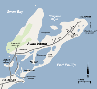
Swan Island is a 1.4 km2 sand barrier island which, with Duck Island and the Edwards Point spit, separate Swan Bay from Port Phillip in Victoria, Australia. It lies close to and north of the town of Queenscliff at the eastern end of the Bellarine Peninsula, and is an official bounded locality of the Borough of Queenscliffe.

The Queenscliff High Light, also variously known as the Black Lighthouse, Fort Queenscliff Lighthouse or Shortland Bluff Light, stands in the grounds of Fort Queenscliff in Queenscliff, Victoria, Australia. It is one of four black lighthouses in the world, and the only one in the Southern Hemisphere. Together with the nearby white Queenscliff Low Light, it was built in 1862 to replace the former sandstone lighthouse of 1843 on the same site which was underpowered and deteriorating.

Fort Queenscliff, in Victoria, Australia, dates from 1860 when an open battery was constructed on Shortland's Bluff to defend the entrance to Port Phillip. The Fort, which underwent major redevelopment in the late 1870s and 1880s, became the headquarters for an extensive chain of forts around Port Phillip Heads. Its garrison included volunteer artillery, engineers, infantry and naval militia, and it was manned as a coastal defence installation continuously from 1883 to 1946. The other fortifications and armaments around the Heads were completed by 1891, and together made Port Phillip one of the most heavily defended harbours in the British Empire.

Pope's Eye is the uncompleted foundation for an island fort intended to defend the entrance to Port Phillip in the state of Victoria, Australia. The undefined area of the fort, generally assessed at 4 hectares, is one of six separate areas that comprise the Port Phillip Heads Marine National Park and is a popular site for divers.
The Port Phillip Heads Marine National Park is a marine protected area located in the vicinity of the bay of Port Phillip, between the Bellarine and Mornington Peninsulas, in Victoria, Australia. The 3,580-hectare (8,800-acre) marine national park comprises six separate sites located approximately 60 kilometres (37 mi) south-west of Melbourne and stretches along 40 kilometres (25 mi) of coastline of Victoria.

South Channel Fort, also known as South Channel Island, is a 0.7 ha artificial island in southern Port Phillip, Victoria, Australia, 6 km north-east of the town of Sorrento. It was part of a network of fortifications protecting the narrow entrance to Port Phillip.

Fort Nepean is a former defensive facility occupying part of Point Nepean, Victoria, Australia. It was part of a network of fortifications, commanded from Fort Queenscliff, protecting the narrow entrance to Port Phillip. It is now part of Point Nepean National Park and a local tourist attraction.

Point Lonsdale Lighthouse, also known as the Point Lonsdale Signal Station, is close to the township of Point Lonsdale in the Borough of Queenscliffe, Victoria, Australia. It stands at the eastern end of the Bellarine Peninsula, on the western side of the entrance to Port Phillip from Bass Strait, on a headland overlooking the "Rip", a stretch of water considered one of the more treacherous navigable passages in the world, and the only seaborne approach to Melbourne. It is operated by Victorian Ports Corporation (Melbourne).
Citadel Island Lighthouse was built in 1913. In 1982, it was replaced by a GRP cabinet while the light was converted to solar power. The old lantern was dismantled in 1992 and removed to Port Albert, where it was restored for display at the Port Albert Maritime Museum in 2004.
The New Burnett Heads Light, also known as South Head Light, is an active lighthouse standing on the south side of the Burnett River entrance, in Burnett Heads, Queensland, Australia. In 1971 it replaced the Old Burnett Heads Light, which was relocated inland.

The Queenscliffe Maritime Museum is a regional maritime museum in the town of Queenscliff at the entrance from Bass Strait to the bay of Port Phillip in Victoria, south-eastern Australia. It lies within walking distance of the Searoad ferry terminal. It covers the maritime history of the Borough of Queenscliffe, southern Port Phillip and the connection with Bass Strait.


