Gabo Island is a 154-hectare (380-acre) island located off the coast of eastern Victoria, Australia, between Mallacoota and Cape Howe on the border with New South Wales. It is separated from the mainland by a 500-metre (1,600 ft) wide channel; access is available by arranged flights and boats. Gabo Island is a shipping reference commonly referred to in Victorian weather warnings issued by the Australian Bureau of Meteorology. The island is an unincorporated area under the direct administration of the government of Victoria.

The Cape Schanck Lighthouse was built in 1859 as the second coastal lighthouse in the Australian state of Victoria. It is located on Cape Schanck, at the southernmost tip of the Mornington Peninsula. The 21 metres (69 ft) tall tower was built from limestone. The light's focal plane is situated 100 metres (330 ft) above sea level, the light characteristic is the Morse code letter "N", a long signal of 10.8 seconds followed by a flash. Depending on the bearing of the light, the colours are either white or red. Due to its powerful lantern of one million candela and a first order Fresnel lens, which was installed in 1915, the light has a range of 26 nmi (48 km).

Cape Liptrap Lighthouse stands upon the rocky cliff top of Cape Liptrap peninsula, on a solitary part of the South Gippsland coastline. The lighthouse warns ships of the rocks in treacherous Bass Strait.
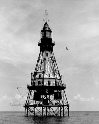
A pile lighthouse is a type of lighthouse found in Australia and the United States. In the United States they are found primarily in Florida, including on open reefs adjacent to the Florida Keys.

Deal Island, the largest island of the Kent Group, is a 1,576-hectare (3,890-acre) granite island, located in northern Bass Strait, that lies between the Furneaux Group, north-east of Tasmania, and Wilsons Promontory, in Victoria, Australia.

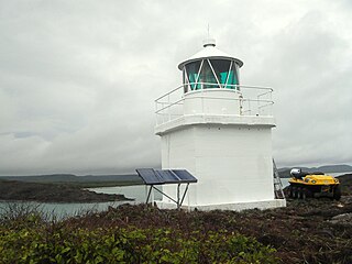
Archer Point Light is an active lighthouse on Archer Point, a conical, 60-metre-high (200 ft) grassy headland about 14 kilometres (8.7 mi) southeast of Cooktown, Queensland, Australia. Originally an 1883 timber frame lighthouse covered with galvanised iron, it was replaced in 1975 with a modern square concrete equipment room topped with a lantern.

Booby Island Light is an active heritage-listed lighthouse located on Booby Island in the Shire of Torres, near the tip of Cape York Peninsula, west of Prince of Wales Island, within the Endeavour Strait, Queensland, Australia. It marks the western entrance to the navigation channel through the Torres Strait. It was the last of the major lights to be constructed along the Queensland coast.
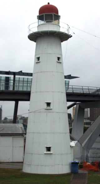
Bulwer Island Light, also known as Bulwer Island Range Rear Light, is an inactive lighthouse that was on Bulwer Island, in the suburb of Pinkenba, City of Brisbane, Queensland, Australia. In 1983, it was moved to the Queensland Maritime Museum in South Brisbane.
The New Burnett Heads Light, also known as South Head Light, is an active lighthouse standing on the south side of the Burnett River entrance, in Burnett Heads, Queensland, Australia. In 1971 it replaced the Old Burnett Heads Light, which was relocated inland.

Cape Capricorn Light is an active heritage-listed lighthouse located on Cape Capricorn, a coastal headland on the northeast point of Curtis Island, in Gladstone Region, Central Queensland, Australia. The lighthouse, constructed in 1964, is the third at this site, following a timber frame lighthouse constructed in 1875 and a concrete lighthouse constructed around 1937. It was added to the Queensland Heritage Register on 31 August 2001.

Cape Bowling Green Light is an active lighthouse on Cape Bowling Green, a long headland ending in a long low sandspit, about 30 kilometres (19 mi) from Ayr, Queensland, Australia. The lighthouse is at the end of the headland, near the base of the sandspit. The first lighthouse at the location, established in 1874, was moved multiple times. It was prefabricated in Brisbane, shipped to the location, moved twice due to coastal erosion and finally transferred for display at the Australian National Maritime Museum at Darling Harbour in Sydney.

Lady Elliot Island Light is an active lighthouse located on Lady Elliot Island, the southernmost coral cay of the Great Barrier Reef, 46 nautical miles north-east of Bundaberg, Queensland, Australia. The lighthouse is located on the western side of the island. It was the third lighthouse erected in Queensland after its formation in 1859 and the first in Australia to be constructed of a timber frame clad with iron plates. The original lighthouse was deactivated in 1995 and the light was replaced by a modern skeletal tower standing close to the original lighthouse.

Dent Island Light is an active lighthouse on Dent Island, a small island off the coast of Queensland, Australia, part of the Whitsunday Group of the Whitsunday Islands. Located on the southwest tip of the island, the light guides ships navigating the Whitsunday Passage, between Whitsunday Island and the islands to the west, and marks the Dent Island Passage.

Double Island Point Light is an active lighthouse located at the summit of Double Island Point, a coastal headland within the Cooloola section of the Great Sandy National Park. It is located at the southern end of Wide Bay, 70 kilometres (43 mi) north of Noosa Heads, Queensland, Australia.
Eborac Island Light is an active lighthouse on Eborac Island, a small rocky island in the Adolphus Channel just off Cape York, the northern tip of Cape York Peninsula, Far North Queensland, Australia. It guides ships into the coastal channel inside the Great Barrier Reef. A concrete structure was built in 1921 and converted to solar power in 1990. It was replaced with a fiberglass structure in 2012.

Wyborn Reef Light is an active lighthouse located at Wyborn Reef, formerly known as Y Reef, about 16 kilometres (9.9 mi) southeast of Albany Island, east of the tip of Cape York Peninsula, Queensland, Australia. It marks the entrance to the Albany Passage. The lighthouse was constructed in 1938 and upgraded in 1991 and 1995. The structure is a stainless steel tower with a fiberglass hut within the framework, carrying a lantern.

Point Hicks Lighthouse is a lighthouse located on the Point Hicks headland, in the East Gippsland region of Victoria, Australia.

The Iron Pot Lighthouse is a lighthouse located on Iron Pot island in Storm Bay, at the mouth of the Derwent River in Hobart, Tasmania, Australia. Constructed in 1832 with convict labor, Iron Pot Lighthouse is the oldest lighthouse in Tasmania and oldest original tower in Australia. It was the first lighthouse in Australia to utilise locally manufactured optics, and became the first Australian lighthouse to use solar power in 1977. The 11-metre (36 ft) tall tower has a range of 11 nautical miles.
Troubridge Hill Lighthouse is a lighthouse located on Troubridge Hill on the south coast of Yorke Peninsula in South Australia about 13.5 kilometres south west of Edithburgh and about 3.7 kilometres west of Troubridge Point.

