External links
- Rowlett, Russ. "The Lighthouse Directory". University of North Carolina at Chapel Hill.
| Types |
|  | ||||
|---|---|---|---|---|---|---|
| Fixtures | ||||||
| Maintenance | ||||||
| Locations | ||||||
| Categories | ||||||
| Global organizations | ||||||
This is a list of lighthouses in Solomon Islands . [1] [2]
| Name | Image | Year built | Location & coordinates | Class of Light [2] | Focal height [2] | NGA number [2] | Admiralty number [2] | Range nml [2] |
|---|---|---|---|---|---|---|---|---|
| Auki Harbour Lighthouse | n/a | Auki 8°46′08.2″S160°42′10.4″E / 8.768944°S 160.702889°E | L Fl WR 5s. | 97 metres (318 ft) | 10700 | K4901 | white. 15 red: 12 | |
| Cape Esperance Lighthouse | n/a | Cape Esperance 9°15′12.7″S159°42′54.0″E / 9.253528°S 159.715000°E | Fl W 10s. | 10 metres (33 ft) | 10652 | K4932 | 10 | |
| Gizo Island Lighthouse | n/a | Gizo 8°04′06.0″S156°50′12.0″E / 8.068333°S 156.836667°E | Fl W 5s. | 9 metres (30 ft) | 10756 | K4893.4 | 5 | |
| Indalilau Islet Lighthouse | n/a | offshore Nggela Islands 9°11′35.4″S160°21′39.9″E / 9.193167°S 160.361083°E | Fl (2) W 10s. | 10 metres (33 ft) | 10680 | K4906 | 10 | |
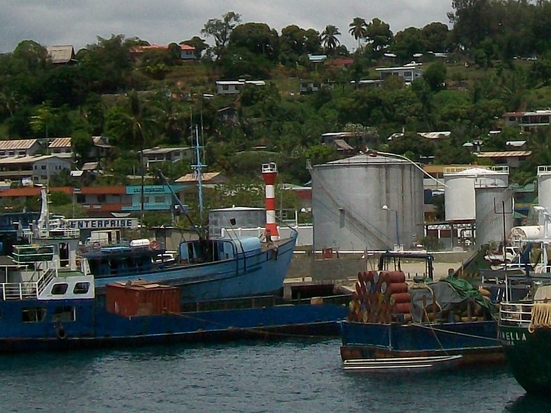
| Honiara Anchorage Range Front Lighthouse | Image | n/a | Honiara 9°25′53.2″S159°57′34.0″E / 9.431444°S 159.959444°E | Fl R 5s. | 13 metres (43 ft) | 10636 | K4934 | 4 |
| Honiara Anchorage Range Rear Lighthouse | n/a | Honiara 9°26′04.7″S159°57′18.9″E / 9.434639°S 159.955250°E | Fl G 5s. | n/a | 10640 | K4934.1 | 4 | |
| Kunda Kunda Reef Lighthouse | n/a | Munda 8°23′00.0″S157°13′36.0″E / 8.383333°S 157.226667°E (NGA) | Fl W 10s. | 10 metres (33 ft) | 10732 | K4896 | 10 | |
| Munda Range Front Lighthouse | n/a | Munda 8°22′12.0″S157°13′48.0″E / 8.370000°S 157.230000°E (NGA) | Fl W 5s. | 9 metres (30 ft) | 10736 | K4896.4 | 5 | |
| Munda Range Rear Lighthouse | n/a | Munda 8°19′49.9″S157°14′05.5″E / 8.330528°S 157.234861°E | Fl (3) W 15s. | 11 metres (36 ft) | 10740 | K4896.41 | 5 | |
| Papara Voghoe Point Lighthouse | n/a | Choiseul Island 4°10′12.0″S156°52′00.0″E / 4.170000°S 156.866667°E | Fl WRG 10s. | 51 metres (167 ft) | 10772 | K4892 | white: 8 red:5 green: 5 | |
| Rere Point Lighthouse | n/a | Mbulo Island 9°34′42.0″S160°36′48.0″E / 9.578333°S 160.613333°E (NGA) | Fl W 5s. | 10 metres (33 ft) | 10608 | K4946 | 5 | |
| Russell Islands Lighthouse | n/a | Russell Islands 8°58′54.5″S159°14′32.6″E / 8.981806°S 159.242389°E | Fl W 10s. | 11 metres (36 ft) | 10724 | K4920 | 10 | |
| Soghonangola Lighthouse | n/a | Tulagi 9°07′25.3″S160°09′22.4″E / 9.123694°S 160.156222°E | Fl (2) R 10s. | 10 metres (33 ft) | 10665 | K4909 | 3 | |
| South Island Lighthouse | n/a | New Georgia 8°48′53.7″S157°45′31.3″E / 8.814917°S 157.758694°E | Fl W 10s. | 11 metres (36 ft) | 10728 | K4898 | 10 | |
| Square Island Lighthouse | n/a | Guadalcanal Province 9°49′23.6″S160°54′14.1″E / 9.823222°S 160.903917°E | Fl W 10s. | 10 metres (33 ft) | 10584 | K4947 | 10 | |
| Taivu Point Lighthouse | n/a | Guadalcanal Province 9°24′42.0″S160°21′00.0″E / 9.411667°S 160.350000°E (NGA) | L Fl (2) W 20s. | 10 metres (33 ft) | 10616 | K4944 | 5 | |
| Tulagi Harbour Range Front Lighthouse | n/a | Tulagi 9°06′08.3″S160°10′07.2″E / 9.102306°S 160.168667°E | Fl W 5s. | 8 metres (26 ft) | 10660 | K4908 | 5 | |
| Tulagi Harbour Range Rear Lighthouse | n/a | Tulagi 9°05′32.4″S160°10′13.1″E / 9.092333°S 160.170306°E | Fl (2) W 10s. | 10 metres (33 ft) | 10664 | K4908.1 | 5 | |
| Wangalaha Point Lighthouse | n/a | Makira 10°18′06.8″S161°35′01.3″E / 10.301889°S 161.583694°E | Fl W 5s. | 30 metres (98 ft) | 10576 | K4947.6 | 8 | |
| Types |
| | ||||
|---|---|---|---|---|---|---|
| Fixtures | ||||||
| Maintenance | ||||||
| Locations | ||||||
| Categories | ||||||
| Global organizations | ||||||