Lighthouses
| Name | Image | Year built | Location & coordinates | Class of Light [2] | Focal height [2] | NGA number [2] | Admiralty number [2] | Range nml [2] |
|---|---|---|---|---|---|---|---|---|
| Betio Lighthouse | n/a | Betio 1°21′15.3″N172°55′14.8″E / 1.354250°N 172.920778°E | Fl W 8s. | 32 metres (105 ft) | 11080 | M8512 | 18 | |
| Enderbury Island Lighthouse |  | 1938 | Enderbury Island 3°08′29.0″S171°05′28.0″W / 3.141389°S 171.091111°W | inactive | 9 metres (30 ft) (tower) | n/a | n/a | n/a |
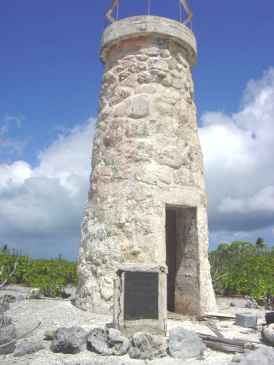
| Canton Island Lighthouse | Image | 1838 | Canton Island 2°48′55.1″S171°42′44.4″W / 2.815306°S 171.712333°W | inactive | 8 metres (26 ft) (tower) | n/a | n/a | n/a |
| Tabuaeran Lighthouse |  | 1957 | Tabuaeran 3°51′31.6″N159°21′43.1″W / 3.858778°N 159.361972°W | F W | 9 metres (30 ft) | 11108 | M8528 | 12 |
| Tarawa Lighthouse | n/a | Tarawa 1°38′09.3″N172°57′23.1″E / 1.635917°N 172.956417°E | L Fl W 20s. | 21 metres (69 ft) | 11076 | M8508 | n/a | |
