
Hornby Lighthouse, also known as South Head Lower Light or South Head Signal Station, is a heritage-listed active lighthouse located on the tip of South Head, New South Wales, Australia, a headland to the north of the suburb Watsons Bay. It marks the southern entrance to Port Jackson and Sydney Harbour, as well as lighting the South Reef, a ledge of submerged rocks. It is the third oldest lighthouse in New South Wales. Designed by Mortimer Lewis and listed on the Register of the National Estate and on the New South Wales State Heritage Register since 2 April 1999, with the following statement of significance:
A dominant Sydney landmark which appears to have been in continuous use since the 1840s as a controlling point for shipping entering and leaving Port Jackson. The building complex, designed by the Colonial Architect Mortimer Lewis in the early 1840s, is an architectural important example of an early Victorian public work associated with port activities.

Bedok Lighthouse is an active lighthouse facility located at the southeastern coast of Singapore. The lighthouse is located on top of a 26-storey condominium at Lagoon View Block 5000K Singapore 449292, Marine Parade Road.

Richmond River Light, also known as Ballina Head Light and Ballina Light, is an active lighthouse located at Ballina Head, a headland in Ballina, New South Wales, Australia. The headland is at the northern side of the entrance to the Richmond River. It used to serve to guide ships into the river port and is used also serves as a leading light into the river, together with a steamer's masthead lantern with a 200 mm lens which is raised on a wooden structure 30 metres (98 ft) from it.

Warden Head Light, also known as Ulladulla Lighthouse, is an active lighthouse on Warden Head, a headland south of Ulladulla, New South Wales, Australia, guarding the entrance to the Port of Ulladulla. It is one of only two wrought iron lighthouses in New South Wales, the other being its sibling, Wollongong Breakwater Lighthouse. It is also notable for two relocations: the tower was constructed in 1873 on the Ulladulla Breakwater, and relocated in 1889 to its current location. Its keeper's house was relocated to a different location in the 1920s.

Bay Rock Light is an inactive lighthouse which used to be located on Bay Rock, a rocky islet northwest of Magnetic Island, about 20 kilometres (12 mi) north of Townsville, Queensland, Australia. First lit in 1886, it was automated in 1920 and deactivated in the 1980s. It was relocated in 1992 to the Townsville Maritime Museum, where it is now displayed.
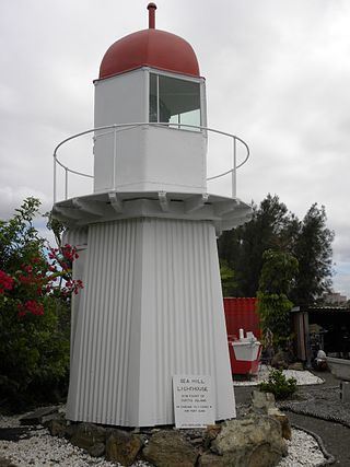
Sea Hill Lighthouse, also known as Sea Hill Point Light or Little Sea Hill Light, is a lighthouse on the northwest point of Curtis Island, Gladstone Region, Queensland, Australia. Its purpose was to mark the east side of the entrance to Keppel Bay, on passage to Fitzroy River and Port Alma. The first lighthouse at the locations was constructed in 1873 or 1876, moved in the 1920s, and is now on display at the Gladstone Maritime Museum. A second lighthouse was constructed in 1895 and its state is unclear.

Goods Island Light is an active lighthouse located on the highest point of Goods Island (Palilag), an island in the Torres Strait, belonging to Queensland, Australia. It serves as the rear light of the Goods Island Range, pointing out the entrance to Normanby Sound.

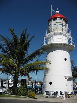
Cape Capricorn Light is an active heritage-listed lighthouse located on Cape Capricorn, a coastal headland on the northeast point of Curtis Island, in Gladstone Region, Central Queensland, Australia. The lighthouse, constructed in 1964, is the third at this site, following a timber frame lighthouse constructed in 1875 and a concrete lighthouse constructed around 1937. It was added to the Queensland Heritage Register on 31 August 2001.

Point Danger Light, also known as the Captain Cook Memorial Light, is an active lighthouse located on Point Danger, a headland between Coolangatta and Tweed Heads, marking the border between Queensland and New South Wales, Australia. It lays claim to be the first lighthouse in the world to experiment with laser as a light source.

Point Cartwright Light is an active lighthouse located on Point Cartwright, a point near the mouth of the Mooloolah River, in Mooloolaba, Queensland, Australia. It marks the entrance to the North West Channel, a deep water channel into Moreton Bay and the Port of Brisbane, and provides guidance into the Mooloolaba Harbour.
Pine Islet Light, also known as Percy Isles Light, is an active lighthouse located at Pine Islet, a small islet belonging to the Percy Isles group of the Northumberland Islands, about 130 kilometres (81 mi) southeast of Mackay, Queensland, Australia. The original lighthouse, established 1885, was active for a hundred years, until it was deactivated in 1985, by then the last kerosene powered lighthouse in Australia. It was relocated to the Mackay Marina in 1985 and restored to full working condition, making it the last fully functional kerosene operated lighthouse in the world. At the original location now stands a modern fiberglass tower.

Low Isles Light, also known as Low Islets Light or Low Island Light, is an active lighthouse located on Low Island, a coral cay which together with Woody Island forms the Low Isles group, about 13 kilometres (8.1 mi) northeast of Port Douglas, Queensland, Australia. The island is situated on the western edge of the main shipping channel into the harbour of Port Douglas, and it marks the entrance to the channel. Built in 1878, it was the first lighthouse in Far North Queensland and more specifically the first to light the Inner Passage of the Great Barrier Reef. Its construction is typical to Queensland lighthouses of the time, timber frame clad with galvanized iron, and it is the fourth lighthouse of this type constructed in Queensland, though it is the first of them to use portholes.
The Gibraltar South Mole Lighthouse is one of several lighthouses in Gibraltar, a British Overseas Territory at the south end of the Iberian Peninsula. Also known as the Gibraltar "A" Head Lighthouse, it has a cast-iron, skeletal tower which is painted black and features two galleries. The lighthouse remains operational and is positioned west of the Rock of Gibraltar, on the South Mole at Gibraltar Harbour. It is operated by the Gibraltar Port Authority.
The Gibraltar North Mole Elbow Lighthouse is one of several lighthouses in Gibraltar, a British Overseas Territory at the south end of the peninsula of Iberia. Also known as the Gibraltar "E" Head Lighthouse, its tower is painted grey. The active lighthouse is west of the Rock of Gibraltar and positioned at the elbow of the North Mole at Gibraltar Harbour. The lighthouse is operated by the Gibraltar Port Authority.

The Dog Island Lighthouse on Dog Island in Foveaux Strait is New Zealand's tallest lighthouse, and one of its oldest. It is notable for its masonry construction, and is a work example by an engineer who was prominent at the time. The lighthouse employed the first revolving beam in New Zealand, and the unique original light apparatus was in use for 60 years. Dog Island Lighthouse is one of the most distinct lighthouses in New Zealand, with only two others having stripes painted on them for better visibility at daytime. The lighthouse is registered by Heritage New Zealand as a Category I structure, and the adjacent lighthouse keepers cottage has a Category II registration. Originally operated by three lighthouse keepers, the structure has since 1989 been remote controlled from Maritime New Zealand's Wellington office, with Dog Island since having been uninhabited. Dog Island Lighthouse has twice featured on New Zealand stamps.
James Melville Balfour was a Scottish-born New Zealand marine engineer. He is best remembered for the network of lighthouses that he designed. Balfour was a highly energetic man, who despite drowning after only six years in the country, has left an impressive list of projects either designed or constructed by him. He was initially employed by the Otago Provincial Council before his appointment by the Government of New Zealand as the colonial marine engineer.

Bean Rock Lighthouse is a lighthouse situated at the end of a reef in the Waitematā Harbour in Auckland, New Zealand. It is the only remaining example in New Zealand of a wooden cottage-style lighthouse, and it is one of only a few remaining worldwide. It is also the oldest wooden lighthouse and only wave-washed tower in New Zealand. It is owned, operated and maintained by Ports of Auckland.

The Farewell Spit Lighthouse is located at the end of New Zealand's longest sand spit in Golden Bay / Mohua, near the northern tip of the South Island. It guides vessels entering Cook Strait from the west and south. The LED rotating beacon flashes white or red, once every 15 seconds. It has a range of 19 nautical miles. Red is shown to warn approaching vessels of extensive shoaling. Standing 27 metres (89 ft) tall, the tower needs to be taller than the support structures of most lighthouses built on cliffs or headlands, because the sand foundations it is built upon are almost at sea level. The tower is constructed of an open steel lattice to withstand abrasive sand and salt-laden winds.


