Nugget Point Lighthouse

Last updated

Nugget Point lighthouse at Sunrise in March of 2019. Nuggetpoint landscape.jpg
Nugget Point lighthouse at Sunrise in March of 2019.
Nugget Point Lighthouse
Nugget Point lighthouse cropped.jpg
Nugget Point lighthouse. Rocky islets (The Nuggets) can be seen beyond the point.
Nugget Point Lighthouse
Location Nugget Point, South Island, New Zealand
Coordinates 46°26′53″S169°49′01″E / 46.44814°S 169.8169°E / -46.44814; 169.8169 Coordinates: 46°26′53″S169°49′01″E / 46.44814°S 169.8169°E / -46.44814; 169.8169
Tower
Constructed1870
Constructionstone tower
Automated1989
Height9 metres (30 ft)
Shapecylindrical tower with balcony and lantern attached to one-story building
Markingswhite tower
Power sourcemains electricity  OOjs UI icon edit-ltr-progressive.svg
Light
First lit1870
Focal height76 metres (249 ft)
Range10 nautical miles (19 km; 12 mi) [1]
Characteristic LFL(2) W 12s.

Nugget Point Lighthouse is a lighthouse at Nugget Point in the Otago region of the South Island of New Zealand. [2] [3] It is owned and operated by Maritime New Zealand.

Contents

History

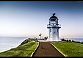
The lighthouse was built from 1869 to 1870 and first lit on 4 July 1870. [1] The tower was constructed from locally quarried stone. The lighting apparatus that was installed had come to New Zealand on the same ship as the lighthouse designer James Balfour in 1863 and was originally intended for the lighthouse at Cape Saunders. With the project on Otago Peninsula experiencing many delays, the lighting apparatus was used at Nugget Point instead. [4] [5]

In 1901 Walter Hutton Champion was the lighthouse keeper along with his wife Alice.

Originally, the lighthouse was powered by an oil burner. In 1949 the oil lamp was replaced with an electric 1000 W lamp powered by a local diesel generator. The generator was replaced in the 1960s by a connection to the mains grid although the original lens for the light remained in place and continued to be used. [1]

The light was fully automated in 1989 and is now monitored and managed from a Maritime New Zealand control room in Wellington. In 2006, the original light was replaced with an LED beacon, powered by mains and backed up by battery. The lighthouse was solarized in May 2020 and now has no mains power. [6]

An easy 20-minute return walking track leads from the car park at the end of The Nuggets Road to a viewing platform right next to the lighthouse overlooking "The Nuggets". The lighthouse itself is fenced off.

See also

Related Research Articles

<span class="mw-page-title-main">Lighthouse</span> Structure designed to emit light to aid navigation

A lighthouse is a tower, building, or other type of physical structure designed to emit light from a system of lamps and lenses and to serve as a beacon for navigational aid, for maritime pilots at sea or on inland waterways.

<span class="mw-page-title-main">Souter Lighthouse</span> Lighthouse in England

Souter Lighthouse is a lighthouse located in the village of Whitburn, Tyne and Wear, England.. Souter Point was the first lighthouse in the world to be actually designed and built specifically to use alternating electric current, the most advanced lighthouse technology of its day. The light was generated by a carbon arc lamp: first lit on 11 January 1871, it was described at the time as 'without doubt one of the most powerful lights in the world'.

<span class="mw-page-title-main">Lizard Lighthouse</span> Lighthouse on the south coast of Cornwall, England

The Lizard Lighthouse is a lighthouse at Lizard Point, Cornwall, England, built to guide vessels passing through the English Channel. It was often the welcoming beacon to persons returning to England, where on a clear night, the reflected light could be seen 100 mi (160 km) away.

<span class="mw-page-title-main">Nugget Point</span> Steep landform in Otago, New Zealand

Nugget Point is one of the most iconic landforms on the Otago coast. Located at the northern end of the Catlins coast, along the road from Kaka Point, this steep headland has a lighthouse at its tip, surrounded by rocky islets. The point is home to many seabirds, including penguins, gannets and royal spoonbills, and a large breeding colony of fur seals. Roaring Bay, on the south coast of the tip of Nugget Point, is home to a small colony of yellow-eyed penguins.

<span class="mw-page-title-main">Cape Reinga Lighthouse</span> Lighthouse in New Zealand

Cape Reinga Lighthouse is a lighthouse at Cape Reinga in the Northland Region of the North Island of New Zealand. It is owned and operated by Maritime New Zealand. The lighthouse is a common New Zealand icon and a popular tourist destination although the lighthouse itself is not open to the public.

<span class="mw-page-title-main">Kātiki Point Lighthouse</span> Lighthouse in New Zealand

The Katiki Point Lighthouse, also known as Moeraki Lighthouse, shone for the first time in 1878, following several accidents on the dangerous reefs around the area, to make the area safer for ships that sailed past on their way to Port Chalmers, Dunedin. The lighthouse was built between the settlements of Moeraki and Katiki, on the tip of the Moeraki Peninsula, which is known as Katiki Point or Moeraki Point.

<span class="mw-page-title-main">Baring Head Lighthouse</span> Lighthouse in New Zealand

Baring Head Lighthouse is a concrete lighthouse at Baring Head in the Wellington Region of the North Island of New Zealand, with an LED beacon powered by mains electricity. It is owned and operated by Maritime New Zealand, and can be accessed via walking tracks in the southern area of the East Harbour Regional Park, south of Wainuiomata.

<span class="mw-page-title-main">Cape Palliser Lighthouse</span> Lighthouse in New Zealand

Cape Palliser Lighthouse is a lighthouse at Cape Palliser in the Wellington region of the North Island of New Zealand. It is owned and operated by Maritime New Zealand.

<span class="mw-page-title-main">Castle Point Lighthouse</span> Lighthouse in New Zealand

Castle Point Lighthouse, located near the village of Castlepoint in the Wellington Region of the North Island of New Zealand, is the North Island's tallest lighthouse standing 52 metres above sea level and is one of only two left in New Zealand with a rotating beam. It is owned and operated by Maritime New Zealand.

<span class="mw-page-title-main">Cape Campbell Lighthouse</span> Lighthouse in New Zealand

Cape Campbell Lighthouse is a lighthouse at Cape Campbell in the Marlborough region of the South Island of New Zealand. It is owned and operated by Maritime New Zealand. The original lighthouse at this site was first lit on 1 August 1870. However, this lighthouse was constructed of timber, and in 1898 these timbers were found to be decaying. This led to the construction of the current cast iron tower, which began operating in October 1905.

<span class="mw-page-title-main">Cape Bonavista Light</span> Lighthouse

Cape Bonavista Light is a lighthouse located on Cape Bonavista, Newfoundland. The lighthouse, which operated from 1843 until 1962, is now a provincial museum, containing an exhibition about life in a lighthouse during the 1870s.

<span class="mw-page-title-main">Point Stephens Light</span> Lighthouse in New South Wales, Australia

The Point Stephens Light is a heritage-listed active lighthouse located on Point Stephens, a point on an unnamed headland at the east of Fingal Bay, 4.25 km (2.64 mi) south of the entrance of Port Stephens, New South Wales, Australia. The light serves to assist vessels entering Port Stephens. It is considered an endangered lighthouse due to remote location and old age.

<span class="mw-page-title-main">Sandy Cape Light</span> Lighthouse

Sandy Cape Light is a heritage-listed active lighthouse located on Sandy Cape, the most northern point on K'gari, Queensland, Australia. It stands about 6 kilometres (3.7 mi) southwest of the northeastern tip of the island. It is the tallest lighthouse in Queensland. Built in 1870, it is the second major lighthouse to be built in Queensland after its formation in 1859. It is one of the first lighthouses in Australia to be constructed using bolted prefabricated segments of cast iron, and one of only two such lighthouses in Queensland, the other being its sibling, Bustard Head Light.

<span class="mw-page-title-main">Cape Moreton Light</span> Lighthouse in Queensland, Australia

Cape Moreton Light, also listed as North Point Range Rear Light, is a heritage-listed active lighthouse located on Cape Moreton, a rocky headland located at the north eastern tip of Moreton Island, a large sand island on the eastern side of Moreton Bay, on the coast of South East Queensland, Australia. It marks the northern entrance to Moreton Bay and Brisbane and also serves as the rear light for the North Point Range. With its two distinctive red bands, it also serves as a daymark. It is the oldest lighthouse in Queensland, and the only one to be built by the New South Wales Government before the separation of Queensland, which took place in 1859. It is also the only lighthouse in Queensland to be built of stone.

<span class="mw-page-title-main">Dent Island Light</span> Lighthouse

Dent Island Light is an active lighthouse on Dent Island, a small island off the coast of Queensland, Australia, part of the Whitsunday Group of the Whitsunday Islands. Located on the southwest tip of the island, the light guides ships navigating the Whitsunday Passage, between Whitsunday Island and the islands to the west, and marks the Dent Island Passage.

<span class="mw-page-title-main">Pine Islet Light</span> Lighthouse

Pine Islet Light, also known as Percy Isles Light, is an active lighthouse located at Pine Islet, a small islet belonging to the Percy Isles group of the Northumberland Islands, about 130 kilometres (81 mi) southeast of Mackay, Queensland, Australia. The original lighthouse, established 1885, was active for a hundred years, until it was deactivated in 1985, by then the last kerosene powered lighthouse in Australia. It was relocated to the Mackay Marina in 1985 and restored to full working condition, making it the last fully functional kerosene operated lighthouse in the world. At the original location now stands a modern fiberglass tower.

<span class="mw-page-title-main">Dog Island Lighthouse</span> Lighthouse at Foveaux Strait, New Zealand

The Dog Island Lighthouse on Dog Island in Foveaux Strait is New Zealand's tallest lighthouse, and one of its oldest. It is notable for its masonry construction, and is a work example by an engineer who was prominent at the time. The lighthouse employed the first revolving beam in New Zealand, and the unique original light apparatus was in use for 60 years. Dog Island Lighthouse is one of the most distinct lighthouses in New Zealand, with only two others having stripes painted on them for better visibility at daytime. The lighthouse is registered by Heritage New Zealand as a Category I structure, and the adjacent lighthouse keepers cottage has a Category II registration. Originally operated by three lighthouse keepers, the structure has since 1989 been remote controlled from Maritime New Zealand's Wellington office, with Dog Island since having been uninhabited. Dog Island Lighthouse has twice featured on New Zealand stamps.

James Melville Balfour was a Scottish-born New Zealand marine engineer. He is best remembered for the network of lighthouses that he designed. Balfour was a highly energetic man, who despite drowning after only six years in the country, has left an impressive list of projects either designed or constructed by him. He was initially employed by the Otago Provincial Council before his appointment by the Government of New Zealand as the colonial marine engineer.

<span class="mw-page-title-main">Cape Espichel Lighthouse</span> Lighthouse in Portugal

Cape Espichel Lighthouse is situated on the western coast of the civil parish of Castelo, municipality of Sesimbra, in the Setúbal district of Portugal. The lighthouse was built in 1790.

<span class="mw-page-title-main">Farewell Spit Lighthouse</span> Lighthouse in New Zealand

The Farewell Spit Lighthouse is located at the end of New Zealand's longest sand spit in Golden Bay / Mohua, near the northern tip of the South Island. It guides vessels entering Cook Strait from the west and south. The LED rotating beacon flashes white or red, once every 15 seconds. It has a range of 19 nautical miles. Red is shown to warn approaching vessels of extensive shoaling. Standing 27 metres (89 ft) tall, the tower needs to be taller than the support structures of most lighthouses built on cliffs or headlands, because the sand foundations it is built upon are almost at sea level. The tower is constructed of an open steel lattice to withstand abrasive sand and salt-laden winds.

References

  1. 1 2 3 Information panel at Nugget Point lighthouse
  2. Rowlett, Russ. "Lighthouses of New Zealand: South Island". The Lighthouse Directory. University of North Carolina at Chapel Hill . Retrieved 23 February 2016.
  3. Nugget Point Lighthouse Archived 14 October 2012 at the Wayback Machine , Maritime New Zealand. Retrieved 24 October 2012.
  4. Aspden, R J. "Balfour, James Melville". Institution of Professional Engineers New Zealand. Archived from the original on 1 December 2017. Retrieved 6 January 2015.
  5. Phillips, Mark. "Cape Saunders (1880)". newzealandlighthouses.com. Archived from the original on 15 January 2015. Retrieved 15 January 2015.
  6. "Nugget Point lighthouse - Maritime NZ". Archived from the original on 1 December 2017. Retrieved 28 July 2022.