Matiu / Somes Island Lighthouse

Last updated

Matiu / Somes Island Lighthouse
Matiu - Somes Island Lighthouse - Flickr - 111 Emergency.jpg
Matiu / Somes Island Lighthouse
Location Matiu / Somes Island, Wellington Region, New Zealand OOjs UI icon edit-ltr-progressive.svg
Coordinates 41°15′35″S174°51′49″E / 41.25967°S 174.86367°E / -41.25967; 174.86367
Tower
Constructed1900  OOjs UI icon edit-ltr-progressive.svg
Constructionbrick (tower)  OOjs UI icon edit-ltr-progressive.svg
Automated1924  OOjs UI icon edit-ltr-progressive.svg
Height9 m (30 ft)  OOjs UI icon edit-ltr-progressive.svg
Shaperound  OOjs UI icon edit-ltr-progressive.svg
Operator Greater Wellington Regional Council   OOjs UI icon edit-ltr-progressive.svg
Light
First lit21 February 1900  OOjs UI icon edit-ltr-progressive.svg
Focal height29 m (95 ft)  OOjs UI icon edit-ltr-progressive.svg
Lenssecond order Fresnel lens  OOjs UI icon edit-ltr-progressive.svg
Range7 nmi (13 km; 8.1 mi)  OOjs UI icon edit-ltr-progressive.svg
Characteristic LFl(3) WRG 10s  OOjs UI icon edit-ltr-progressive.svg
Original lighthouse OOjs UI icon edit-ltr-progressive.svg
Somes Island Lighthouse - old and new towers.jpg
Constructed1866  OOjs UI icon edit-ltr-progressive.svg
Constructioncast iron (tower), brick (foundation)  OOjs UI icon edit-ltr-progressive.svg
Height10 ft (3.0 m)  OOjs UI icon edit-ltr-progressive.svg
Shapeoctagon  OOjs UI icon edit-ltr-progressive.svg
Power sourcerapeseed oil, kerosene  OOjs UI icon edit-ltr-progressive.svg
First lit17 February 1866  OOjs UI icon edit-ltr-progressive.svg
Lensfourth order Fresnel lens  OOjs UI icon edit-ltr-progressive.svg

The Matiu / Somes Island lighthouse is a harbour navigation light located on Matiu / Somes Island in Wellington Harbour, New Zealand. It is a sector light, marking a safe approach through the harbour channel. The first lighthouse on the site was established in 1866. It was the first inner harbour lighthouse in New Zealand, and one of only eight lighthouses nationwide at that time. However, by 1895 there were multiple complaints that it was inadequate. A replacement lighthouse with a more powerful light was built on an adjacent site and commissioned on 21 February 1900. The light was automated on 1 April 1924 and converted to electricity after 1945. The lighthouse is currently operated and maintained by the Greater Wellington Regional Council.

Contents

The first lighthouse

A signal station was established on Somes Island around 1840, but it was not until 1866 that the first lighthouse on the site was erected to aid safe navigation in the harbour. [1] [2] The lighthouse was built upon an octagonal cast iron tower, 10 feet (3.0 m) high, bolted to a brick foundation. The lantern contained a fourth order Fresnel lens, and had a 270 degree illumination angle. The lighthouse served as a sector light, marking a safe approach through the harbour channel, and was fitted with ruby and green glass screens either side of a white beam directed down the channel. The light was first lit on 17 February 1866. [3] The lamp initially burned colza oil until it was converted to kerosene in 1878. [4]

When commissioned it was the first inner harbour lighthouse in New Zealand, and one of only eight lighthouses nationwide at that time. [4]

The lighthouse was originally the responsibility of the Wellington Provincial Council, but was transferred to the Marine Department in 1874, prior to the abolition of provincial government in 1876. [5] :93 By 1895 there were complaints to the Marine Department that the Somes Island light was inadequate. [6] [7] A decision was made to upgrade the Somes Island light from a fourth order to a second order, and a replacement lighthouse apparatus was ordered in 1898. [3]

The original lighthouse was dismantled in 1900 [8] and was later re-installed at Tuhawaiki (Jack's) Point Timaru. [3]

Replacement in 1900

Somes Island lighthouse - in 1915 Somes Island lighthouse circa 1915.jpg
Somes Island lighthouse - in 1915

The replacement lighthouse was built on a circular brick tower adjacent to the existing lighthouse. [4] The design made use of the lantern that had become available from the decommissioning in 1897 of the first Farewell Spit lighthouse. [9] The new Somes Island lighthouse was commissioned on 21 February 1900. [3]

The lighthouse was automated on 1 April 1924 with the installation of a flashing Dalén light supplied by the AGA company. The light used an acetylene burning lamp combined with a solar sensor which automatically operates the light only during darkness. [2] [10] It was converted to an electrical light after 1945. [3]

Lighthouse operations

The first lighthouse keepers were William Lyall (Principal keeper) and David Susan. [10]

In 1912, the management of the station was transferred from the Marine Department to the Wellington Harbour Board, although the Marine Department continued to maintain the light and charge costs to the Board. [11]

The responsibility for ownership and operation of the lighthouse was transferred to the Greater Wellington Regional Council in 1989. The original lighthouse reserve is now part of the Matiu / Somes scientific reserve. [5] :93 [12]

Related Research Articles

<span class="mw-page-title-main">Matiu / Somes Island</span> Island in New Zealand

Matiu / Somes Island is the largest of three islands in the northern half of Wellington Harbour, New Zealand. The island is 24.9 hectares in area, and lies 3 kilometres south of the suburb of Petone and the mouth of the Hutt River.

<span class="mw-page-title-main">Farewell Spit</span> Narrow sand spit in New Zealand

Farewell Spit is a narrow sand spit at the northern end of the Golden Bay, in the South Island of New Zealand. The spit includes around 25 kilometres (16 mi) of stable land and another 5 kilometres (3.1 mi) of mobile sand spit running eastwards from Cape Farewell, the northern-most point of the South Island. Farewell Spit is the longest sand spit in New Zealand, and is a legally protected Nature Reserve. The area is designated as a Ramsar wetland site and an East Asian–Australasian Flyway Shorebird Network site. Farewell Spit is administered by the New Zealand Department of Conservation as a seabird and wildlife reserve. Apart from a small area at the base of the spit, it is closed to the public except through organised tours.

<span class="mw-page-title-main">Cape Foulwind</span>

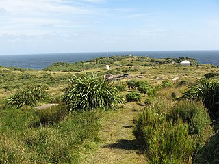
Cape Foulwind is a headland on the West Coast of the South Island of New Zealand, overlooking the Tasman Sea. It is located 11 kilometres (6.8 mi) west of the town of Westport. There is a lighthouse located on a prominent site on the headland. A walkway beginning at the lighthouse carpark traverses the rocky headland to Tauranga Bay and passes close by a colony of New Zealand fur seals. There is limestone quarry in the area, and a cement works operated nearby from 1958 to 2016.

<span class="mw-page-title-main">Puysegur Point</span>

Puysegur Point is a headland located in the far southwest of the South Island of New Zealand. It lies within Fiordland National Park on the southern head of Preservation Inlet and is 145 kilometres (90 mi) west-northwest of Invercargill.

<span class="mw-page-title-main">Old St Paul's, Wellington</span> Historic Anglican church in Wellington, New Zealand

Old St Paul's is a historic site, a city landmark and a wedding and event venue in the heart of Wellington, the capital city of New Zealand. The building served a dual role as the parish church of Thorndon and the pro-cathedral of the Diocese of Wellington of the Anglican Church between 1866 and 1964. It exemplifies 19th-century Gothic Revival architecture adapted to colonial conditions and materials, and stands at 34 Mulgrave Street, Pipitea, close to Parliament Buildings.

<span class="mw-page-title-main">Charles Luke (politician)</span>

Sir Charles Manley Luke was a New Zealand politician and company director. He served as mayor of Wellington in 1895. His brother, Sir John Luke, was later mayor of Wellington from 1913 to 1921.

<span class="mw-page-title-main">Navigational aid</span> Marker to assist in safe passage making

A navigational aid (NAVAID), also known as aid to navigation (ATON), is any sort of signal, markers or guidance equipment which aids the traveler in navigation, usually nautical or aviation travel. Common types of such aids include lighthouses, buoys, fog signals, and day beacons.

<span class="mw-page-title-main">Ferries in Wellington</span>

Ferries within Wellington's harbour carry commuters and tourists on Wellington Harbour and form a part of the Wellington public transport system. They operate between central Wellington, Days Bay, Seatoun, and Matiu/Somes Island. Until 2016, services also ran to Petone on weekends. Historically they also served Lowry Bay and Rona Bay—the ferries belonged to the Eastbourne Borough Council from 1913 to 1950—and briefly, until 1913, Miramar and Karaka Bay. The development of road connections around the harbour's edge, particularly once they were paved during the 1920s, reduced the importance of ferries to the city's transport network, but regular services still run.

<span class="mw-page-title-main">Hutt Valley Line</span>

The Hutt Valley Line is the electrified train service operated by Transdev Wellington on behalf of Metlink on the section of the Wairarapa Line railway between Wellington and Upper Hutt, New Zealand.

<span class="mw-page-title-main">Union Company</span>

Union Steam Ship Company of New Zealand Limited was once the biggest shipping line in the southern hemisphere and New Zealand's largest private-sector employer. It was incorporated by James Mills in Dunedin in 1875 with the backing of a Scottish shipbuilder, Peter Denny. Bought by shipping giant P&O around the time of World War I it was sold in 1972 to an Australasian consortium and closed at the end of the twentieth century.

<span class="mw-page-title-main">1924 Chatham Cup</span> Football tournament season

The 1924 Chatham Cup was the second annual nationwide knockout football competition in New Zealand.

<span class="mw-page-title-main">Steeple Rock</span>

Steeple Rock/Te Aroaro-o-Kupe is a large rock off Seatoun at the west of the entrance to Wellington Harbour, rising 7 metres (23 ft) above sea level. The rock plays a role in warning ships off the coast. It is the location of a marine light and an unbeaconed trig station.

<span class="mw-page-title-main">Evans Bay</span> Bay in Wellington, New Zealand

Evans Bay is a large bay at the southern end of Wellington Harbour, New Zealand. Located between the Miramar Peninsula and Hataitai, it was the site of New Zealand's first patent slip and served as Wellington's international flying-boat terminal from 1938 until 1956. It is named after George Samuel Evans, an early Wellington settler.

Bard Productions, based in Wellington, New Zealand, is a theatre company best known for offering site-specific and 'adventure theatre.' The company has been in operation since 2007.

<span class="mw-page-title-main">Roseneath, Wellington</span> Suburb in Wellington City, New Zealand

Roseneath is a suburb of Wellington, New Zealand, located east of Oriental Bay and north of Hataitai. The peninsula was named after Rosneath, a village on the Rosneath peninsula on Scotland's River Clyde, and has no association with roses.

<span class="mw-page-title-main">Puysegur Point Lighthouse</span> Lighthouse in New Zealand

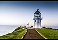
The Puysegur Point Lighthouse is located on a remote headland overlooking the Tasman Sea at the southwest corner of New Zealand's South Island. The Puysegur Point headland is near the entrance to Rakituma / Preservation Inlet in Fiordland National Park. The lighthouse marks the northwest point of the entrance to Foveaux Strait, separating Stewart Island from the South Island. Puysegur Point is one of the most isolated and inaccessible lighthouses in New Zealand.

<span class="mw-page-title-main">Jas J Niven & Co</span> New Zealand engineering business

Jas J Niven & Co Limited later Niven Engineering, was a New Zealand engineering business based in Wellington with operations throughout the country. The foundry that became Niven's business was established in Napier in 1866.

<span class="mw-page-title-main">Farewell Spit Lighthouse</span> Lighthouse in New Zealand

The Farewell Spit Lighthouse is located at the end of New Zealand's longest sand spit in Golden Bay / Mohua, near the northern tip of the South Island. It guides vessels entering Cook Strait from the west and south. The LED rotating beacon flashes white or red, once every 15 seconds. It has a range of 19 nautical miles. Red is shown to warn approaching vessels of extensive shoaling. Standing 27 metres (89 ft) tall, the tower needs to be taller than the support structures of most lighthouses built on cliffs or headlands, because the sand foundations it is built upon are almost at sea level. The tower is constructed of an open steel lattice to withstand abrasive sand and salt-laden winds.

<span class="mw-page-title-main">Evans Bay Patent Slip</span> New Zealand marine railway

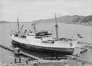
The Evans Bay Patent Slip is a heritage site of the former patent slip located in Evans Bay, in Wellington Harbour in the North Island of New Zealand. The first slipway on the site was commissioned in May 1863 to enable maintenance of the hulls of small vessels. The Wellington Provincial Council was keen to encourage shipping trade by improving facilities in Wellington Harbour and began planning later in 1863 for the construction of a larger patent slip. A concession was granted for the supply, construction and operation of a patent slip on the site. Equipment for the new slip was delivered in 1865 and 1866, but construction was delayed for several years because of a contractual dispute concerning the suitability of the design for the ground conditions. The original suppliers lost a court case and withdrew from the project. The Wellington Patent Slip Company was formed to take over the assets, and construction began in 1871. The Patent Slip was officially opened in March 1873.

<span class="mw-page-title-main">Waiwhetu Aquifer</span> Aquifer in Wellington, New Zealand

The Waiwhetu artesian aquifer, sometimes referred to as the Hutt aquifer, is a pressurized zone of water-retaining sand, gravel and boulders beneath the Hutt Valley and Wellington Harbour in New Zealand. The aquifer provides about 40% of the public fresh water supply for Lower Hutt and Wellington city. Water from the Hutt River begins to flow underground south from Taita Gorge, then becomes pressurized under a seal of clay. Water is extracted from the pressurized area for public use, but concerns about overuse and damage by earthquakes have lead to investigations of alternative sources of fresh water.

References

  1. "Report of the Crown Lands Commissioner - Appendix A". New Zealand Times . 1 May 1875 via Papers Past.
  2. 1 2 "Somes Island Light - Automatic beacon now in operation". Evening Post. 2 April 1924. Retrieved 15 June 2022 via Papers Past.
  3. 1 2 3 4 5 Nalder, Guinevere (December 2007). Southern Lights - The Scottish Contribution to New Zealand's Lighthouses. Dunbeath: Whittles Publishing Ltd. ISBN   978-1-84995-156-2. Wikidata   Q112554192.
  4. 1 2 3 Walton, Tony (March 2001). "Matiu / Somes Island Lighthouse" (PDF). Department of Conservation. Retrieved 14 June 2022.
  5. 1 2 Janet Hector (2011). A new cloak for Matiu: the restoration of an island ecology. Lower Hutt: Forest & Bird. ISBN   978-0-473-18388-2. OCLC   712647074. Wikidata   Q118304061.
  6. "The Shipmasters Association". Evening Post. 21 October 1895. Retrieved 15 June 2022 via Papers Past.
  7. Kennedy, A. (12 February 1897). "Harbour Lights". Evening Post. Retrieved 15 June 2022 via Papers Past.
  8. "Late Shipping". Evening Post. 24 August 1900. Retrieved 15 June 2022 via Papers Past.
  9. "Political News and Notes - Somes Island Lighthouse". Evening Post. 8 August 1898 via Papers Past.
  10. 1 2 "Somes Island Light - Sixty-six Years' Service". Evening Post. 9 July 1932. Retrieved 15 June 2022 via Papers Past.
  11. "Somes Island Light - Automatic Beacon". Evening Star. 5 April 1924. Retrieved 21 June 2022 via Papers Past.
  12. "Navigation aids". Greater Wellington Regional Council. Retrieved 28 March 2023.