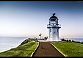
Castle Point Lighthouse

Last updated

Castle Point Lighthouse
Castlepoint Lighthouse.jpg
Castle Point Lighthouse
Location Castlepoint
North Island
New Zealand
Coordinates 40°54′01.5″S176°13′53.2″E / 40.900417°S 176.231444°E / -40.900417; 176.231444
Tower
Constructed1913
Foundationconcrete
Constructioncast iron tower
Automated1988
Height23 metres (75 ft)
Shapetapered cylindrical tower with balcony and lantern
Markingswhite tower, gray lantern dome
Power sourcemains electricity  OOjs UI icon edit-ltr-progressive.svg
Operator Maritime New Zealand [1]
Light
First lit1913
Focal height52 metres (171 ft)
Lenssecond order Fresnel lens  OOjs UI icon edit-ltr-progressive.svg
Range26 nautical miles (48 km; 30 mi)
Characteristic Fl (3) W 30s.

Castle Point Lighthouse, located near the village of Castlepoint in the Wellington Region of the North Island of New Zealand, [2] is the North Island's tallest lighthouse standing 52 metres above sea level and is one of only two left in New Zealand still lit by the original rotating fresnel lens. It is owned and operated by Maritime New Zealand.

Contents

History

The light was built in 1913 and was originally fueled by oil. It was officially lit for the first time on Sunday 12 January 1913, sending out a triple flash every 45 seconds that could be seen for 35 kilometres. [3] In 1954 the oil lamp was replaced with an electric incandescant lamp powered by a local diesel generator. This was subsequently replaced by a connection to the mains grid in 1961. The nearby Castlepoint beach is popular with holiday makers and the lighthouse itself became a popular tourist attraction, acquiring the nickname "The Holiday Light".

The light was fully automated in 1988 and is monitored 24/78 by Maritime NZ in Wellington.

See also

Related Research Articles

<span class="mw-page-title-main">Lighthouse</span> Structure designed to emit light to aid navigation

A lighthouse is a tower, building, or other type of physical structure designed to emit light from a system of lamps and lenses and to serve as a beacon for navigational aid, for maritime pilots at sea or on inland waterways.

<span class="mw-page-title-main">Eastbourne, New Zealand</span> Suburb of Lower Hutt, New Zealand

Eastbourne is a suburb of Lower Hutt, a part of Wellington, New Zealand. Lying beside the sea, it is a popular local tourist destination via car from Petone or from ferry crossings from central Wellington. An outer suburb, it lies on the eastern shore of Wellington Harbour, five kilometres south of the main Lower Hutt urban area and directly across the harbour from the Miramar Peninsula in Wellington city. A narrow exposed coastal road connects it with the rest of Lower Hutt via the Eastern Bays and the industrial suburb of Seaview. It is named for Eastbourne in England, another seaside town known as a destination for day-trips.

<span class="mw-page-title-main">The Brothers (New Zealand)</span>

The Brothers is a group of small islands in Cook Strait, New Zealand, off the east coast of Cape Koamaru, Arapaoa Island. The islands are a restricted-access wildlife sanctuary administered by the Department of Conservation.

<span class="mw-page-title-main">Pendeen Lighthouse</span> Lighthouse

Pendeen Lighthouse, also known as Pendeen Watch is an active aid to navigation located 2 kilometres (1.2 mi) to the north of Pendeen in west Cornwall, England. It is located within the Aire Point to Carrick Du SSSI, the Cornwall Area of Outstanding Natural Beauty and the Penwith Heritage Coast. The South West Coast Path passes to the south.

<span class="mw-page-title-main">Castlepoint</span> Beachside settlement in New Zealand

Castlepoint is a small beachside settlement on the Wairarapa coast of the Wellington Region of New Zealand. It is home to a lighthouse which stands near the top of the northern end of a reef. The reef is about one kilometre long. At the southern end of the reef, there is an island known locally as "seagull island", due to its large population of seagulls. The southern side of Castle Rock is known as Christmas Bay. Castlepoint is approximately one hour's drive from Masterton.

<span class="mw-page-title-main">Cape Reinga Lighthouse</span> Lighthouse in New Zealand

Cape Reinga Lighthouse is a lighthouse at Cape Reinga in the Northland Region of the North Island of New Zealand. It is owned and operated by Maritime New Zealand. The lighthouse is a common New Zealand icon and a popular tourist destination although the lighthouse itself is not open to the public.

<span class="mw-page-title-main">Kātiki Point Lighthouse</span> Lighthouse in New Zealand

The Kātiki Point Lighthouse, also known as Moeraki Lighthouse, shone for the first time in 1878, following several accidents on the dangerous reefs around the area, to make the area safer for ships that sailed past on their way to Port Chalmers, Dunedin. The lighthouse was built between the settlements of Moeraki and Kātiki, on the tip of the Moeraki Peninsula, which is known as Kātiki Point or Moeraki Point.

<span class="mw-page-title-main">Baring Head Lighthouse</span> Lighthouse in New Zealand

Baring Head Lighthouse is a concrete lighthouse at Baring Head in the Wellington Region of the North Island of New Zealand, with an LED beacon powered by mains electricity. It is owned and operated by Maritime New Zealand, and can be accessed via walking tracks in the southern area of the East Harbour Regional Park, south of Wainuiomata.

<span class="mw-page-title-main">Pencarrow Head Lighthouse</span> Lighthouse in New Zealand

Pencarrow Head Lighthouse is a decommissioned lighthouse at Pencarrow Head in the Wellington region of the North Island of New Zealand.

<span class="mw-page-title-main">Cape Palliser Lighthouse</span> Lighthouse in New Zealand

Cape Palliser Lighthouse is a lighthouse at Cape Palliser in the Wellington region of the North Island of New Zealand. It is owned and operated by Maritime New Zealand.

<span class="mw-page-title-main">Nugget Point Lighthouse</span> Lighthouse in New Zealand

Nugget Point Lighthouse is a lighthouse at Nugget Point in the Otago region of the South Island of New Zealand. It is owned and operated by Maritime New Zealand.

<span class="mw-page-title-main">Mokohinau Islands Lighthouse</span> Lighthouse in New Zealand

Mokohinau Islands Lighthouse is a lighthouse on Burgess Island, one of the Mokohinau Islands, which lie off the northeast coast of the North Island of New Zealand. It is owned and operated by Maritime New Zealand. The lighthouse sits at the entrance to the Hauraki Gulf as the landfall light for vessels approaching Auckland from the north and northeast.

<span class="mw-page-title-main">Cape Campbell Lighthouse</span> Lighthouse in New Zealand

Cape Campbell Lighthouse is a lighthouse at Cape Campbell in the Marlborough region of the South Island of New Zealand. It is owned and operated by Maritime New Zealand. The original lighthouse at this site was first lit on 1 August 1870. However, this lighthouse was constructed of timber, and in 1898 these timbers were found to be decaying. This led to the construction of the current cast iron tower, which began operating in October 1905.

<span class="mw-page-title-main">Kiama Light</span> Lighthouse in New South Wales, Australia

Kiama Light, also known as Kiama Harbour Light, is an active lighthouse in Kiama, New South Wales, Australia. The lighthouse is located close to the Kiama Blowhole on Blowhole Point, south of Kiama Harbour.

<span class="mw-page-title-main">Cape Moreton Light</span> Lighthouse in Queensland, Australia

Cape Moreton Light, also listed as North Point Range Rear Light, is a heritage-listed active lighthouse located on Cape Moreton, a rocky headland located at the north eastern tip of Moreton Island, a large sand island on the eastern side of Moreton Bay, on the coast of South East Queensland, Australia. It marks the northern entrance to Moreton Bay and Brisbane and also serves as the rear light for the North Point Range. With its two distinctive red bands, it also serves as a daymark. It is the oldest lighthouse in Queensland, and the only one to be built by the New South Wales Government before the separation of Queensland, which took place in 1859. It is also the only lighthouse in Queensland to be built of stone.

<span class="mw-page-title-main">Dog Island Lighthouse</span> Lighthouse at Foveaux Strait, New Zealand

The Dog Island Lighthouse on Dog Island in Foveaux Strait is New Zealand's tallest lighthouse, and one of its oldest. It is notable for its masonry construction, and is a work example by an engineer who was prominent at the time. The lighthouse employed the first revolving beam in New Zealand, and the unique original light apparatus was in use for 60 years. Dog Island Lighthouse is one of the most distinct lighthouses in New Zealand, with only two others having stripes painted on them for better visibility at daytime. The lighthouse is registered by Heritage New Zealand as a Category I structure, and the adjacent lighthouse keepers cottage has a Category II registration. Originally operated by three lighthouse keepers, the structure has since 1989 been remote controlled from Maritime New Zealand's Wellington office, with Dog Island since having been uninhabited. Dog Island Lighthouse has twice featured on New Zealand stamps.

<span class="mw-page-title-main">Stephens Island Lighthouse</span> Lighthouse

The Stephens Island / Takapourewa lighthouse is one of New Zealand most powerful lights with a range of 18 nautical miles. Perched 183 metres (600 ft) up, on top of Stephens Island, it guards Cook Strait and Tasman Bay / Te Tai-o-Aorere, at the top of the South Island / Te Wai Pounamu.The light flashes white once every six seconds from a white cast iron tower.

<span class="mw-page-title-main">Bean Rock Lighthouse</span> Lighthouse in New Zealand

Bean Rock Lighthouse is a lighthouse situated at the end of a reef in the Waitematā Harbour in Auckland, New Zealand. It is the only remaining example in New Zealand of a wooden cottage-style lighthouse, and it is one of only a few remaining worldwide. It is also the oldest wooden lighthouse and only wave-washed tower in New Zealand. It is owned, operated and maintained by Ports of Auckland.

<span class="mw-page-title-main">Cape Foulwind Lighthouse</span> Lighthouse on New Zealands South Island

The Cape Foulwind Lighthouse is a lighthouse that is located at Cape Foulwind, 11 km (7 mi) west of the town of Westport on the West Coast of New Zealand's South Island. Perched 70 metres (230 ft) above the Tasman Sea, the light guides vessels along the Buller coast, and is one of the most accessible lighthouses in the country. The LED light flashes white once every 12 seconds and has a range 10 nautical miles. It is a Category 2 heritage listed structure.

<span class="mw-page-title-main">Farewell Spit Lighthouse</span> Lighthouse in New Zealand

The Farewell Spit Lighthouse is located at the end of New Zealand's longest sand spit in Golden Bay / Mohua, near the northern tip of the South Island. It guides vessels entering Cook Strait from the west and south. The LED rotating beacon flashes white or red, once every 15 seconds. It has a range of 19 nautical miles. Red is shown to warn approaching vessels of extensive shoaling. Standing 27 metres (89 ft) tall, the tower needs to be taller than the support structures of most lighthouses built on cliffs or headlands, because the sand foundations it is built upon are almost at sea level. The tower is constructed of an open steel lattice to withstand abrasive sand and salt-laden winds.

References

  1. Rowlett, Russ. "Lighthouses of New Zealand: North Island". The Lighthouse Directory. University of North Carolina at Chapel Hill . Retrieved 13 November 2015.
  2. Castle Point Lighthouse profile Archived 21 November 2018 at the Wayback Machine (from the Maritime New Zealand website)
  3. "castlepointlighthouse.com". Archived from the original on 15 December 2017. Retrieved 15 December 2017.