Cape Brett Lighthouse

Last updated

Cape Brett Lighthouse
Cape Brett Lighthouse.jpg
Cape Brett Lighthouse
Location Cape Brett
North Island
New Zealand
Coordinates 35°10′31.1″S174°19′57.3″E / 35.175306°S 174.332583°E / -35.175306; 174.332583
Tower
Constructed1910 (first)
Constructioncast iron tower (first)
fibreglass tower (current)
Automated1978  OOjs UI icon edit-ltr-progressive.svg
Heightapprox. 15 metres (49 ft) (first)
4 metres (13 ft) (current)
Shapecylindrical tower with lantern
Markingswhite tower
Operator Department of Conservation [1]
HeritageHeritage New Zealand Category 1 historic place listing  OOjs UI icon edit-ltr-progressive.svg
Light
First lit1978 (current)
Deactivated1978 (first)
Focal height146 metres (479 ft)
Range17 nmi (31 km; 20 mi)  OOjs UI icon edit-ltr-progressive.svg
Characteristic Fl W 15s. (current)
Designated26 June 2009
Reference no. 7799

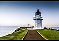
Cape Brett Lighthouse is a lighthouse at Cape Brett in the Northland Region of the North Island of New Zealand. The site was surveyed and chosen in 1908 by Captain John Bollons of NZGSS Hinemoa. [2]

Contents

The lighthouse was deactivated and keepers were withdrawn in 1978 and replaced by an automated beacon on the same site.

Cape Brett Lighthouse and its associated structures are on the Heritage New Zealand list as a Category 1 Historic Place List No: 7799. It was registered on 26 June 2009. [3]

See also

Related Research Articles

<span class="mw-page-title-main">Sentinel Island Light</span> Lighthouse in southeastern Alaska, US

The Sentinel Island Light is a lighthouse in Alaska adjacent to Lynn Canal.

<span class="mw-page-title-main">Cape Reinga Lighthouse</span> Lighthouse in New Zealand

Cape Reinga Lighthouse is a lighthouse at Cape Reinga in the Northland Region of the North Island of New Zealand. It is owned and operated by Maritime New Zealand. The lighthouse is a common New Zealand icon and a popular tourist destination although the lighthouse itself is not open to the public.

<span class="mw-page-title-main">Cape Egmont Lighthouse</span> Lighthouse in New Zealand

Cape Egmont Lighthouse is a lighthouse at Cape Egmont in the Taranaki Region of the North Island of New Zealand. It is owned and operated by Maritime New Zealand. The light was manufactured by Simpson & Co., Pimlico, London, in 1864 and erected on Mana Island to the north west of Porirua in 1865, but it was sometimes confused with the Pencarrow Head light at the entrance to Wellington Harbour and in 1877 the light was dismantled and moved to Cape Egmont.

<span class="mw-page-title-main">East Cape Lighthouse</span> Lighthouse in New Zealand

Access to Otiki Hill passes through private property, and since November 2021 has been restricted - owing to Covid-19 concerns. The current advice is not to travel to the cape until further notice.

<span class="mw-page-title-main">Pencarrow Head Lighthouse</span> Lighthouse in New Zealand

Pencarrow Head Lighthouse is a decommissioned lighthouse at Pencarrow Head in the Wellington region of the North Island of New Zealand.

<span class="mw-page-title-main">Cape Hotham Light</span> Lighthouse in Northern Territory, Australia

Cape Hotham Light is an active lighthouse in the Northern Territory of Australia located on Cape Hotham on the coastline of the Van Diemen Gulf about 80 kilometres (50 mi) northeast of the territory capital of Darwin, The lighthouse marks the entrance to Clarence Strait, the eastern approach to Darwin.

<span class="mw-page-title-main">Archer Point Light</span> Lighthouse in Queensland, Australia

Archer Point Light is an active lighthouse on Archer Point, a conical, 60-metre-high (200 ft) grassy headland about 29km southeast of Cooktown, Queensland, Australia. Originally an 1883 timber frame lighthouse covered with galvanised iron, it was replaced in 1975 with a modern square concrete equipment room topped with a lantern.

<span class="mw-page-title-main">Booby Island Light</span> Lighthouse

Booby Island Light is an active heritage-listed lighthouse located on Booby Island in the Shire of Torres, near the tip of Cape York Peninsula, west of Prince of Wales Island, within the Endeavour Strait, Queensland, Australia. It marks the western entrance to the navigation channel through the Torres Strait. It was the last of the major lights to be constructed along the Queensland coast.

The New Burnett Heads Light, also known as South Head Light, is an active lighthouse standing on the south side of the Burnett River entrance, in Burnett Heads, Queensland, Australia. In 1971 it replaced the Old Burnett Heads Light, which was relocated inland.

<span class="mw-page-title-main">Bustard Head Light</span> Lighthouse

Bustard Head Light is an active lighthouse located on the southeast tip of Bustard Head, a headland, about 20 kilometres (12 mi) northwest of Seventeen Seventy, in the Australian state of Queensland, within the Eurimbula National Park and locality of Eurimbula. Built in 1868, it is the second-oldest lightstation in the state, following Cape Moreton Light, and the first to be built in Queensland after its formation in 1859. It is also one of the first in Australia to be constructed using bolted prefabricated segments of cast iron, and one of only two such lighthouses in Queensland, the other being its sibling, Sandy Cape Light. It serves as the central relay for Dent Island Light, Pine Islet Light and Lady Elliot Island Light and as the radio check post for Cape Capricorn Light, Sandy Cape Light and Double Island Point Light.

<span class="mw-page-title-main">Sandy Cape Light</span> Lighthouse

Sandy Cape Light is a heritage-listed active lighthouse located on Sandy Cape, the most northern point on K'gari, Queensland, Australia. It stands about 6 kilometres (3.7 mi) southwest of the northeastern tip of the island. It is the tallest lighthouse in Queensland. Built in 1870, it is the second major lighthouse to be built in Queensland after its formation in 1859. It is one of the first lighthouses in Australia to be constructed using bolted prefabricated segments of cast iron, and one of only two such lighthouses in Queensland, the other being its sibling, Bustard Head Light.

<span class="mw-page-title-main">Cape Capricorn Light</span> Lighthouse in Queensland, Australia

Cape Capricorn Light is an active heritage-listed lighthouse located on Cape Capricorn, a coastal headland on the northeast point of Curtis Island, in Gladstone Region, Central Queensland, Australia. The lighthouse, constructed in 1964, is the third at this site, following a timber frame lighthouse constructed in 1875 and a concrete lighthouse constructed around 1937. It was added to the Queensland Heritage Register on 31 August 2001.

<span class="mw-page-title-main">Point Cartwright Light</span> Lighthouse

Point Cartwright Light is an active lighthouse located on Point Cartwright, a point near the mouth of the Mooloolah River, in Mooloolaba, Queensland, Australia. It marks the entrance to the North West Channel, a deep water channel into Moreton Bay and the Port of Brisbane, and provides guidance into the Mooloolaba Harbour.

<span class="mw-page-title-main">Cape Bowling Green Light</span> Lighthouse in Queensland, Australia

Cape Bowling Green Light is an active lighthouse on Cape Bowling Green, a long headland ending in a long low sandspit, about 30 kilometres (19 mi) from Ayr, Queensland, Australia. The lighthouse is at the end of the headland, near the base of the sandspit. The first lighthouse at the location, established in 1874, was moved multiple times. It was prefabricated in Brisbane, shipped to the location, moved twice due to coastal erosion and finally transferred for display at the Australian National Maritime Museum at Darling Harbour in Sydney.

<span class="mw-page-title-main">Lady Elliot Island Light</span> Lighthouse

Lady Elliot Island Light is an active lighthouse located on Lady Elliot Island, the southernmost coral cay of the Great Barrier Reef, 46 nautical miles north-east of Bundaberg, Queensland, Australia. The lighthouse is located on the western side of the island. It was the third lighthouse erected in Queensland after its formation in 1859 and the first in Australia to be constructed of a timber frame clad with iron plates. The original lighthouse was deactivated in 1995 and the light was replaced by a modern skeletal tower standing close to the original lighthouse.

<span class="mw-page-title-main">Cape Cleveland Light</span> Lighthouse in Queensland, Australia

Cape Cleveland Light is an active heritage-listed lighthouse located on the northern tip of Cape Cleveland, a promontory projecting into the Coral Sea west of Cleveland Bay in the locality of Cape Cleveland about 40 kilometres (25 mi) east of Townsville, Queensland, Australia. The lighthouse marks the northern point of the Cape, and the entrance to Cleveland Bay.

<span class="mw-page-title-main">Dent Island Light</span> Lighthouse

Dent Island Light is an active lighthouse on Dent Island, a small island off the coast of Queensland, Australia, part of the Whitsunday Group of the Whitsunday Islands. Located on the southwest tip of the island, the light guides ships navigating the Whitsunday Passage, between Whitsunday Island and the islands to the west, and marks the Dent Island Passage.

<span class="mw-page-title-main">Low Isles Light</span> Lighthouse

Low Isles Light, also known as Low Islets Light or Low Island Light, is an active lighthouse located on Low Island, a coral cay which together with Woody Island forms the Low Isles group, about 13 kilometres (8.1 mi) northeast of Port Douglas, Queensland, Australia. The island is situated on the western edge of the main shipping channel into the harbour of Port Douglas, and it marks the entrance to the channel. Built in 1878, it was the first lighthouse in Far North Queensland and more specifically the first to light the Inner Passage of the Great Barrier Reef. Its construction is typical to Queensland lighthouses of the time, timber frame clad with galvanized iron, and it is the fourth lighthouse of this type constructed in Queensland, though it is the first of them to use portholes.

<span class="mw-page-title-main">Dog Island Lighthouse</span> Lighthouse at Foveaux Strait, New Zealand

The Dog Island Lighthouse on Dog Island in Foveaux Strait is New Zealand's tallest lighthouse, and one of its oldest. It is notable for its masonry construction, and is a work example by an engineer who was prominent at the time. The lighthouse employed the first revolving beam in New Zealand, and the unique original light apparatus was in use for 60 years. Dog Island Lighthouse is one of the most distinct lighthouses in New Zealand, with only two others having stripes painted on them for better visibility at daytime. The lighthouse is registered by Heritage New Zealand as a Category I structure, and the adjacent lighthouse keepers cottage has a Category II registration. Originally operated by three lighthouse keepers, the structure has since 1989 been remote controlled from Maritime New Zealand's Wellington office, with Dog Island since having been uninhabited. Dog Island Lighthouse has twice featured on New Zealand stamps.

References

  1. Rowlett, Russ. "Lighthouses of New Zealand: North Island". The Lighthouse Directory. University of North Carolina at Chapel Hill . Retrieved 13 November 2015.
  2. "Cape Brett Lighthouse". Archived from the original on 14 October 2008. Retrieved 24 April 2009.
  3. "Cape Brett Lighthouse Station". Heritage New Zealand Pouhere Taonga. Archived from the original on 23 January 2019. Retrieved 19 November 2018.